| |||||||||||||||||||||||||||||||||||||||||||||||||||||||||||||||||||||
| |||||||||||||||||||||||||||||||||||||||||||||||||||||||||||||||||||||
| |||||||||||||||||||||||||||||||||||||||||||||||||||||||||||||||||||||
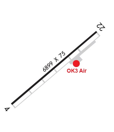
| Rwy | Rwy | |||||||
| 6898x75 | 6898' | 6898x75 | 6898' | |||||
| Runway ID | Single Wheel | Double Wheel | Double Tandem Wheel | Dual Double Wheel |
| 04/22 | 30,000 | N/A | N/A | N/A |
| These numbers are Advisory and are not limits. The Airport Manager should have more accurate Weight Limits | ||||
 Airport Diagram might not be current. | |
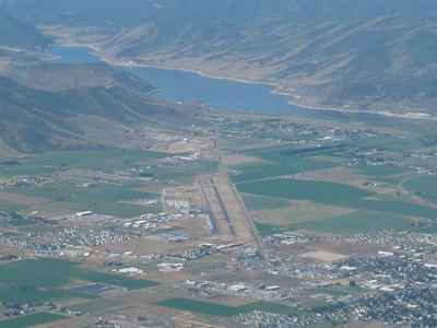
| Facility Name: | HEBER VALLEY |
| City Name: | HEBER |
| County: | WASATCH |
| State abbrev: | UT |
| State Name: | UTAH |
| Ownership: | PUBLICLY OWNED |
| Use: | OPEN TO THE PUBLIC |
| Owner's Name: | HEBER CITY |
| Address: | 75 N. MAIN STREET |
| HEBER, UT 84032 | |
| Owner's Phone: | 435-654-0757 |
| Manager's Name: | TRAVIS BIGGS |
| Address: | 630 W AIRPORT RD., BOX 2 |
| HEBER, UT 84032 | |
| Phone: | 435-657-7949 |
| FAA Region: | NORTHWEST MOUNTAIN |
| FAA Field Office: | DEN |
| Date | Sunrise | Sunset |
|---|---|---|
| 04/26/24 Friday | 6:30 | 20:17 |
| 04/27/24 Saturday | 6:29 | 20:18 |
| 04/28/24 Sunday | 6:28 | 20:19 |
| 04/29/24 Monday | 6:26 | 20:20 |
| 04/30/24 Tuesday | 6:25 | 20:21 |
| 05/01/24 Wednesday | 6:24 | 20:22 |
| 05/02/24 Thursday | 6:22 | 20:23 |
| 05/03/24 Friday | 6:21 | 20:24 |
| 05/04/24 Saturday | 6:20 | 20:25 |
| 05/05/24 Sunday | 6:19 | 20:26 |
| 05/06/24 Monday | 6:18 | 20:27 |
| 05/07/24 Tuesday | 6:17 | 20:28 |
| 05/08/24 Wednesday | 6:15 | 20:29 |
| 05/09/24 Thursday | 6:14 | 20:30 |
| Airport Attendance Schedule | MAY-OCT 7 Days A Week 0800-1830, NOV-APR 7 Days A Week 0800-1700 |
| Airport Status | OPERATIONAL (This Status can change at any time - please check NOTAMS) |
| Airport Lighting Schedule | ACTVT PAPI RWY 22; MIRL RWY 4/22 - CTAF. |
| Airport Storage Available | Tie Downs, Hanger |
| Extra Services Available | Glider, Flight Instruction, Aircraft Rental, Aircraft Sales, Glider Towing |
| Wind Indicator | YES - (lighted) |
| Control Tower | NO |
| CTAF Frequency | 122.800 |
| Unicom Frequency | 122.800 |
| Rotating Beacon Color | WG |
| Segmented Circle | YES |
| Landing Fee | YES; LNDG FEES: TSNT ACFT > 8,000 LBS MTOW, $4.00 PER 1,000 LBS; TSNT ACFT < 8,000 LBS MTOW, $4.00. |
| Airport Inspected | STATE - performed by PRIVATE CONTRACT PERSONNEL |
| Inspection Date | 09/18/2023 |
| Type of Fuel Available | Grade 100LL, JET A (freeze point -40C)J |
| Airframe Repair Service | MAJOR |
| Power Plant Repair Service | MAJOR |
| Latitude | N4028.9 |
| Longitude | W11125.7 (ESTIMATED) |
| Arpt Elevation | 5636ft (SURVEYED) |
| Magnetic Variation | 11E |
| 1 miles S | of HEBER |
| Traffic Pattern Altitude | |
| Sectional Chart | SALT LAKE CITY |
| Operations (Reported) | Yearly | Avg. Daily |
|---|---|---|
| General Aviation Transient | 7500 | 21 |
| General Aviation Local | 4620 | 13 |
| Air Taxi | 1056 | 3 |
| Commerical | 0 | 0 |
| Commuter | 0 | 0 |
| Military | 24 | 0 |
| Aircraft based on Field | |
|---|---|
| General Aviation Singles | 111 |
| General Aviation Multi | 11 |
| Jet Aircraft | 16 |
| General Aviation Helicopters | 5 |
| Military Aircraft | 0 |
| Gliders | 17 |
| Ultralights | 1 |
| FSS on field | NO |
| FSS tie-in | CEDAR CITY |
| FSS Phone | 1-800-WX-BRIEF |
| Who issues Notams | CDC |
| Notam D service at airport | YES |
| ARTCC Name | SALT LAKE CITY |
| Airport Certification | |
| Aircraft Rescue & Firefighting Index | None |
| Airport of Entry | No |
| Custom Landing Rights | No |
| Joint Civil/Military | No |
| Military Landing rights | YES |
| NATIONAL PLAN OF INTEGRATED AIRPORT SYSTEMS (NPIAS) |
| GRANT AGREEMENTS UNDER FAAP/ADAP/AIP |
| ASSURANCES PURSUANT TO TITLE VI, CIVIL RIGHTS ACT OF 1964 |
| ACFT DEPARTING SOUTH-SOUTHWESTBOUND BE AWARE OF HIGH TFC VOLUME DESCENDING TO 16,000 FT OVER SPANE INTERSECTION. |
| GLIDER ACTIVITY ON AND INVOF ARPT. |
| BALLOON ACTIVITY ON AND INVOF ARPT. |
| SNOW REMOVAL NOV-APR. |
| FOR CD CTC SALT LAKE ARTCC AT 801-320-2568. |
| PREFERRED CALM WIND RWY 22. |
| COLD TEMP ARPT. ALT COR RQRD AT OR BELOW -17C. |
| BIRDS ON & INVOF ARPT. |
Airport Communications & Frequencies:
| |||||||||
| Runway: 04 | Runway: 22 | ||
| Mag heading: | 39° | Mag heading: | 219° |
| Rwy Slope: | .78% Up | Rwy Slope: | -.78% Down |
| Approach: | Approach: | ||
| Pattern: | Left Traffic | Pattern: | Left Traffic |
| Markings: | NONPRECISION INSTRUMENT | Markings: | NONPRECISION INSTRUMENT |
| Marking Condition: | GOOD | Marking Condition: | GOOD |
| Arresting Dev: | Arresting Dev: | ||
| Lat & Long: | N4028.5 W11126.3 | Lat. & Long.: | N4029.3 W11125.2 |
| Elev: | 5583.0 ft. MSL | Elev: | 5636.8 ft. MSL |
| TCH: | TCH: | 42 ft. AGL | |
| Visual Glide Path: | Visual Glide Path: | 4.00 degrees | |
| Displaced Threshold: | No | Displaced Threshold: | No |
| Touchdown Zone: | YES | Touchdown Zone: | YES |
| Touchdown Elev.: | 5608.4 feet | Touchdown Elev.: | 5636.8 feet |
| Visual Glide Slope: | Visual Glide Slope: | 4-Light PAPI on LEFT side of Runway; PAPI UNUSBL BYD 3.5 NM FM THLD AND BYD 6 DEGS LEFT AND RIGHT OF CNTRLN. | |
| RVR Equipment: | RVR Equipment: | ||
| RVV Equipment: | NO | RVV Equipment: | NO |
| Approach Lights: | Approach Lights: | ||
| REIL: | NO | REIL: | NO |
| Centerline Lights: | NO | Centerline Lights: | NO |
| Touchdown lights: | NO | Touchdown lights: | NO |
| Runway Category: | Runway with a Non-precision Approach having visibility minimums greater than 3/4 mile | Runway Category: | Runway with a Non-precision Approach having visibility minimums greater than 3/4 mile |
| Declared Distances: | Declared Distances: | ||
| Obstructions: | Obstructions: | ROAD | |
| Marked: | Marked: | NOT Marked/Lighted | |
| Clearance slope: | 34:1 | Clearance slope: | 23:1 |
| Obstruction height: | Obstruction height: | 12 feet AGL | |
| Dist. from runway: | Dist. from runway: | 486 feet | |
| Centerline offset: | Centerline offset: | 395 feet right of centerline | |
| Comments: | Comments: |