
| ||||||||||||||||||||||||||||||||||||||||||||
| ||||||||||||||||||||||||||||||||||||||||||||
| ||||||||||||||||||||||||||||||||||||||||||||
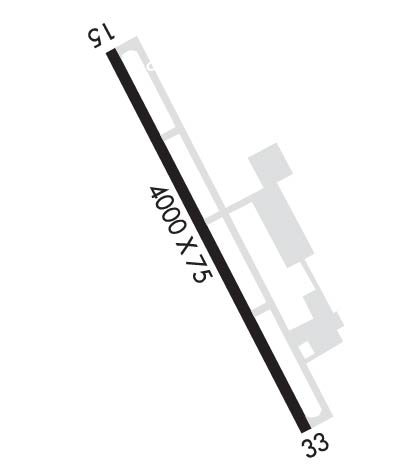
| Rwy | Rwy | |||||||
| 4000x75 | 4000' | 4000x75 | 4000' | |||||
| Runway ID | Single Wheel | Double Wheel | Double Tandem Wheel | Dual Double Wheel |
| 15/33 | N/A | N/A | N/A | N/A |
| These numbers are Advisory and are not limits. The Airport Manager should have more accurate Weight Limits | ||||
 Airport Diagram might not be current. | |
| Facility Name: | HUTCHINSON MUNI/BUTLER FLD |
| City Name: | HUTCHINSON |
| County: | MC LEOD |
| State abbrev: | MN |
| State Name: | MINNESOTA |
| Ownership: | PUBLICLY OWNED |
| Use: | OPEN TO THE PUBLIC |
| Owner's Name: | CITY OF HUTCHINSON |
| Address: | 111 HASSAN ST SE |
| HUTCHINSON, MN 55350-2522 | |
| Owner's Phone: | 320-587-5151 |
| Manager's Name: | JOHN OLSON |
| Address: | 1400 ADAMS ST SE |
| HUTCHINSON, MN 55350-7010 | |
| Phone: | 320-234-4473 |
| FAA Region: | GREAT LAKES |
| FAA Field Office: | DMA |

| Date | Sunrise | Sunset |
|---|---|---|
| 04/18/24 Thursday | 6:27 | 20:08 |
| 04/19/24 Friday | 6:25 | 20:09 |
| 04/20/24 Saturday | 6:23 | 20:10 |
| 04/21/24 Sunday | 6:22 | 20:11 |
| 04/22/24 Monday | 6:20 | 20:13 |
| 04/23/24 Tuesday | 6:18 | 20:14 |
| 04/24/24 Wednesday | 6:17 | 20:15 |
| 04/25/24 Thursday | 6:15 | 20:16 |
| 04/26/24 Friday | 6:14 | 20:18 |
| 04/27/24 Saturday | 6:12 | 20:19 |
| 04/28/24 Sunday | 6:10 | 20:20 |
| 04/29/24 Monday | 6:09 | 20:21 |
| 04/30/24 Tuesday | 6:07 | 20:23 |
| 05/01/24 Wednesday | 6:06 | 20:24 |
| Airport Attendance Schedule | MON-FRI 0800-1700 |
| Airport Status | OPERATIONAL (This Status can change at any time - please check NOTAMS) |
| Airport Lighting Schedule | ACTVT OR INCR INTST REIL RWY 15 & 33; PAPI RWY 15 & 33; MIRL RWY 15/33 - CTAF. MIRL RWY 15/33 PRESET LOW INTST. |
| Airport Storage Available | Tie Downs, Hanger |
| Extra Services Available | Crop Dusting, Aircraft Rental, Aircraft Sales |
| Wind Indicator | YES - (lighted) |
| Control Tower | NO |
| CTAF Frequency | 122.800 |
| Unicom Frequency | 122.800 |
| Rotating Beacon Color | WG |
| Segmented Circle | YES |
| Landing Fee | NO |
| Airport Inspected | STATE - performed by STATE AERONAUTICAL PERSONNEL |
| Inspection Date | 06/22/2021 |
| Type of Fuel Available | Grade 100LL, JET A (freeze point -40C); -10AVBL H24 VIA CREDIT CARD.; -A AVBL H24 VIA CREDIT CARD. |
| Airframe Repair Service | MAJOR |
| Power Plant Repair Service | MAJOR |
| Latitude | N4451.6 |
| Longitude | W09423.0 (ESTIMATED) |
| Arpt Elevation | 1062ft (SURVEYED) |
| Magnetic Variation | 04E |
| 2 miles S | of HUTCHINSON |
| Traffic Pattern Altitude | |
| Sectional Chart | TWIN CITIES |
| Operations (Reported) | Yearly | Avg. Daily |
|---|---|---|
| General Aviation Transient | 5400 | 15 |
| General Aviation Local | 6750 | 18 |
| Air Taxi | 200 | 1 |
| Commerical | 0 | 0 |
| Commuter | 0 | 0 |
| Military | 45 | 0 |
| Aircraft based on Field | |
|---|---|
| General Aviation Singles | 45 |
| General Aviation Multi | 2 |
| Jet Aircraft | 0 |
| General Aviation Helicopters | 0 |
| Military Aircraft | 0 |
| Gliders | 0 |
| Ultralights | 0 |
| FSS on field | NO |
| FSS tie-in | PRINCETON |
| FSS Phone | 1-800-WX-BRIEF |
| Who issues Notams | HCD |
| Notam D service at airport | YES |
| ARTCC Name | MINNEAPOLIS |
| Airport Certification | |
| Aircraft Rescue & Firefighting Index | None |
| Airport of Entry | No |
| Custom Landing Rights | No |
| Joint Civil/Military | No |
| Military Landing rights | YES |
| NATIONAL PLAN OF INTEGRATED AIRPORT SYSTEMS (NPIAS) |
| ASSURANCES PURSUANT TO TITLE VI, CIVIL RIGHTS ACT OF 1964 |
| GRANT AGREEMENT HAS EXPIRED; HOWEVER, AGREEMENT REMAINS IN EFFECT FOR THIS FACILITY AS LONG AS IT IS PUBLIC USE. |
| GCO AVBL ON FREQ 121.725 THRU MINNEAPOLIS ARTCC & FLT SVCS. |
| FOR CD IF UNA VIA GCO CTC MINNEAPOLIS ARTCC AT 651-463-5588. |
Airport Communications & Frequencies:
| |||||||||
| Runway: 15 | Runway: 33 | ||
| Mag heading: | 148° | Mag heading: | 328° |
| Rwy Slope: | .19% Up | Rwy Slope: | -.19% Down |
| Approach: | Approach: | ||
| Pattern: | Left Traffic | Pattern: | Left Traffic |
| Markings: | NONPRECISION INSTRUMENT | Markings: | NONPRECISION INSTRUMENT |
| Marking Condition: | GOOD | Marking Condition: | GOOD |
| Arresting Dev: | Arresting Dev: | ||
| Lat & Long: | N4451.9 W09423.2 | Lat. & Long.: | N4451.3 W09422.7 |
| Elev: | 1054.7 ft. MSL | Elev: | 1062.3 ft. MSL |
| TCH: | 40 ft. AGL | TCH: | 40 ft. AGL |
| Visual Glide Path: | 3.00 degrees | Visual Glide Path: | 3.00 degrees |
| Displaced Threshold: | No | Displaced Threshold: | No |
| Touchdown Zone: | YES | Touchdown Zone: | YES |
| Touchdown Elev.: | 1060.7 feet | Touchdown Elev.: | 1062.3 feet |
| Visual Glide Slope: | 4-Light PAPI on LEFT side of Runway | Visual Glide Slope: | 4-Light PAPI on LEFT side of Runway |
| RVR Equipment: | RVR Equipment: | ||
| RVV Equipment: | NO | RVV Equipment: | NO |
| Approach Lights: | Approach Lights: | ||
| REIL: | YES | REIL: | YES |
| Centerline Lights: | NO | Centerline Lights: | NO |
| Touchdown lights: | NO | Touchdown lights: | NO |
| Runway Category: | Runway with a Non-precision Approach having visibility minimums greater than 3/4 mile | Runway Category: | Runway with a Non-precision Approach having visibility minimums greater than 3/4 mile |
| Declared Distances: | Declared Distances: |