| ||||||||||||||||||||||||||||||||||||||||||||||||||||||||||||||||||||
| ||||||||||||||||||||||||||||||||||||||||||||||||||||||||||||||||||||
| ||||||||||||||||||||||||||||||||||||||||||||||||||||||||||||||||||||
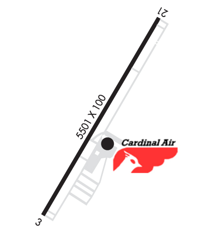
| Rwy | Rwy | |||||||
| 5501x100 | 5501' | 5501x100 | 5501' | |||||
| Runway ID | Single Wheel | Double Wheel | Double Tandem Wheel | Dual Double Wheel |
| 03/21 | 30,000 | 60,000 | N/A | N/A |
| These numbers are Advisory and are not limits. The Airport Manager should have more accurate Weight Limits | ||||
 Airport Diagram might not be current. | |
| Facility Name: | ASHEBORO RGNL |
| City Name: | ASHEBORO |
| County: | RANDOLPH |
| State abbrev: | NC |
| State Name: | NORTH CAROLINA |
| Ownership: | PUBLICLY OWNED |
| Use: | OPEN TO THE PUBLIC |
| Owner's Name: | CITY OF ASHEBORO |
| Address: | P. O. BOX 1106 |
| ASHEBORO, NC 27204-1106 | |
| Owner's Phone: | 336-626-1201 |
| Manager's Name: | RICHARD MCCRAW |
| Address: | 2222 PILOTS VIEW RD |
| ASHEBORO, NC 27205-1106 | |
| Phone: | 336-625-6120; FOR SVC AFTER HOURS CALL 919-357-7254. |
| FAA Region: | SOUTHERN |
| FAA Field Office: | MEM |
| Date | Sunrise | Sunset |
|---|---|---|
| 04/19/24 Friday | 6:41 | 19:57 |
| 04/20/24 Saturday | 6:40 | 19:58 |
| 04/21/24 Sunday | 6:38 | 19:58 |
| 04/22/24 Monday | 6:37 | 19:59 |
| 04/23/24 Tuesday | 6:36 | 20:00 |
| 04/24/24 Wednesday | 6:35 | 20:01 |
| 04/25/24 Thursday | 6:34 | 20:02 |
| 04/26/24 Friday | 6:32 | 20:03 |
| 04/27/24 Saturday | 6:31 | 20:03 |
| 04/28/24 Sunday | 6:30 | 20:04 |
| 04/29/24 Monday | 6:29 | 20:05 |
| 04/30/24 Tuesday | 6:28 | 20:06 |
| 05/01/24 Wednesday | 6:27 | 20:07 |
| 05/02/24 Thursday | 6:26 | 20:08 |
| Airport Attendance Schedule | OCT-MAY 7 Days A Week 0800-DUSK, JUNE-SEPT 7 Days A Week 0800-2000 |
| Airport Status | OPERATIONAL (This Status can change at any time - please check NOTAMS) |
| Airport Lighting Schedule | DUSK-2300; ACTVT REIL RWY 03 & 21; PAPI RWY 03 & 21; AND AFTER 2300, MIRL RWY 03/21 - CTAF. |
| Airport Storage Available | Tie Downs, Hanger |
| Extra Services Available | Flight Instruction, Aircraft Rental |
| Wind Indicator | YES - (lighted) |
| Control Tower | NO |
| CTAF Frequency | 122.800 |
| Unicom Frequency | 122.800 |
| Rotating Beacon Color | WG |
| Segmented Circle | YES |
| Landing Fee | NO |
| Airport Inspected | STATE - performed by STATE AERONAUTICAL PERSONNEL |
| Inspection Date | 04/02/2021 |
| Type of Fuel Available | Grade 100LL, JET A-1 (icing inhibitor, freeze point -50C); -10100LL 24 HR SELF SVC AVBL WITH CREDIT CARD. |
| Airframe Repair Service | MAJOR |
| Power Plant Repair Service | MAJOR |
| Latitude | N3539.3 |
| Longitude | W07953.7 (ESTIMATED) |
| Arpt Elevation | 670ft (SURVEYED) |
| Magnetic Variation | 08W |
| 6 miles SW | of ASHEBORO |
| Traffic Pattern Altitude | |
| Sectional Chart | CHARLOTTE |
| Operations (Reported) | Yearly | Avg. Daily |
|---|---|---|
| General Aviation Transient | 7000 | 19 |
| General Aviation Local | 8000 | 22 |
| Air Taxi | 0 | 0 |
| Commerical | 0 | 0 |
| Commuter | 0 | 0 |
| Military | 500 | 1 |
| Aircraft based on Field | |
|---|---|
| General Aviation Singles | 38 |
| General Aviation Multi | 4 |
| Jet Aircraft | 0 |
| General Aviation Helicopters | 0 |
| Military Aircraft | 0 |
| Gliders | 0 |
| Ultralights | 0 |
| FSS on field | NO |
| FSS tie-in | RALEIGH |
| FSS Phone | 1-800-WX-BRIEF |
| Who issues Notams | HBI |
| Notam D service at airport | YES |
| ARTCC Name | ATLANTA |
| Airport Certification | |
| Aircraft Rescue & Firefighting Index | None |
| Airport of Entry | No |
| Custom Landing Rights | No |
| Joint Civil/Military | No |
| Military Landing rights | YES |
| NATIONAL PLAN OF INTEGRATED AIRPORT SYSTEMS (NPIAS) |
| ASSURANCES PURSUANT TO TITLE VI, CIVIL RIGHTS ACT OF 1964 |
| GRANT AGREEMENT HAS EXPIRED; HOWEVER, AGREEMENT REMAINS IN EFFECT FOR THIS FACILITY AS LONG AS IT IS PUBLIC USE. |
| TERRAIN RISING SOUTH OF THE ARPT. |
| RWY 03 HAS 40 FT DROP-OFF 400 FT FM THR; 0B. |
| NORTH CAROLINA AVIATION MUSEUM HALL OF FAME LCTD ON FLD. |
| FOR CD CTC GREENSBORO APCH AT 743-222-6129. |
Airport Communications & Frequencies:
| ||||||||||||||
| Runway: 03 | Runway: 21 | ||
| Mag heading: | 30° | Mag heading: | 210° |
| Rwy Slope: | -.05% Down | Rwy Slope: | .05% Up |
| Approach: | Approach: | ||
| Pattern: | Left Traffic | Pattern: | Left Traffic |
| Markings: | NONPRECISION INSTRUMENT | Markings: | NONPRECISION INSTRUMENT |
| Marking Condition: | GOOD | Marking Condition: | GOOD |
| Arresting Dev: | Arresting Dev: | ||
| Lat & Long: | N3538.8 W07953.9 | Lat. & Long.: | N3539.7 W07953.5 |
| Elev: | 670.8 ft. MSL | Elev: | 668.1 ft. MSL |
| TCH: | 48 ft. AGL | TCH: | 40 ft. AGL |
| Visual Glide Path: | 3.50 degrees | Visual Glide Path: | 3.00 degrees |
| Displaced Threshold: | No | Displaced Threshold: | No |
| Touchdown Zone: | YES | Touchdown Zone: | YES |
| Touchdown Elev.: | 670.8 feet | Touchdown Elev.: | 668.1 feet |
| Visual Glide Slope: | 2-Light PAPI on LEFT side of Runway | Visual Glide Slope: | 2-Light PAPI on LEFT side of Runway |
| RVR Equipment: | RVR Equipment: | ||
| RVV Equipment: | NO | RVV Equipment: | NO |
| Approach Lights: | Approach Lights: | ||
| REIL: | YES | REIL: | YES |
| Centerline Lights: | NO | Centerline Lights: | NO |
| Touchdown lights: | NO | Touchdown lights: | NO |
| Runway Category: | Runway with a Non-precision Approach having visibility minimums greater than 3/4 mile | Runway Category: | Runway with a Non-precision Approach having visibility minimums greater than 3/4 mile |
| Declared Distances: | Declared Distances: | ||
| Obstructions: | TREES | Obstructions: | TREES |
| Marked: | NOT Marked/Lighted | Marked: | NOT Marked/Lighted |
| Clearance slope: | 22:1 | Clearance slope: | 36:1 |
| Obstruction height: | 398 feet AGL | Obstruction height: | 40 feet AGL |
| Dist. from runway: | 8976 feet | Dist. from runway: | 1674 feet |
| Centerline offset: | 533 right of centerline | Centerline offset: | 292 feet right of centerline |
| Comments: | Comments: | HAS 11 FT GND 0-200 FT FM THR 241 FT RIGHT OF CNTRLN. |