KHAO

BUTLER CO RGNL
HAMILTON
OH
Time Zone: Eastern
Lat: N 3921.8
Long: W 08431.3
Elev: 632
Var: +05
Longest Runway: 5500
Clr Del: 126.25
AWOS: 121.42
CTAF: 123.05

FBO & Flight Services info for KHAO

FBOs: Update your Fuel Prices

CINCINNATI JET CTPh: 513-867-9500 Fax: 513-867-0149 Freq: 123.05
Service
Jet
100LL
SAF
MoGas
Fuel Avail: JET A w/PRIST ADD $0.05/gal. VOLUME DISCOUNTS AVAILABLE
Full6.357.38    Last Update: 04/23/2024 09:43
PRICES GUARANTEED by FBO.
Self        
 Address: 2820 BOBMEYER ROAD,   HAMILTON OH 45015
ASOSPh: 513-863-6137
-
Freq: 121.42  
If you are an FBO, call 1-203-262-1700 to update your info or email: FltPlan.Advertising@garmin.com
Advertise your FBO on FltPlan.com

Runway & Approach Info for KHAO
Rwy
Length
Land Dist**
Approach*
  Rwy
Length
Land Dist**
Approach*
11
5500x100  5500'          
 
  
29
  5500x100  5500'          
ILS/DME
 109.75 - 295°  
 * only ILS, LOC, LDA, and SDF approaches to a specific runway are shown
** For any Declared Landing Distance Available, please see A/FD or Approach plates
Runway Weight Capability (lbs.) Help
Runway IDSingle WheelDouble WheelDouble Tandem WheelDual Double Wheel
11/2960,00075,00039,000N/A
These numbers are Advisory and are not limits.   The Airport Manager should have more accurate Weight Limits
Approach Charts
Approaches    
Current Weather/Notams
Customs Information Send updates to Support@FltPlan.com
Customs Not Available
Database effective 05/16/2024
Airport Diagram of KHAO
Airport Diagram might not be current.

Facility Name: BUTLER COUNTY RGNL/HOGAN FLD
City Name: HAMILTON
County: BUTLER
State abbrev: OH
State Name: OHIO
   
Ownership: PUBLICLY OWNED
Use: OPEN TO THE PUBLIC
Owner's Name: BUTLER COUNTY BD OF COMMISSIONERS
Address: 2820 AIRPORT ROAD EAST
 HAMILTON, OH 45015-1499
Owner's Phone: 513-887-3412
  
Manager's Name: JOSH CLAYTON
Address: 2820 AIRPORT ROAD EAST
 HAMILTON, OH 45015-1499
Phone: 513-785-5444; CELL 513-309-0562.
   
FAA Region: GREAT LAKES
FAA Field Office: DET


Sunrise / Sunset times for BUTLER COUNTY RGNL/HOGAN FLD

DateSunriseSunset
04/23/24 Tuesday6:4920:24
04/24/24 Wednesday6:4720:25
04/25/24 Thursday6:4620:26
04/26/24 Friday6:4520:27
04/27/24 Saturday6:4320:28
04/28/24 Sunday6:4220:29
04/29/24 Monday6:4120:30
04/30/24 Tuesday6:4020:31
05/01/24 Wednesday6:3820:32
05/02/24 Thursday6:3720:33
05/03/24 Friday6:3620:34
05/04/24 Saturday6:3520:35
05/05/24 Sunday6:3420:36
05/06/24 Monday6:3320:37

Airport Facilities

Airport Attendance ScheduleNOV-MAR 7 Days A Week 0700-2100, APR-OCT 7 Days A Week 0700-2200
Airport Status OPERATIONAL (This Status can change at any time - please check NOTAMS)
Airport Lighting ScheduleACTVT MALS RWY 29; REIL RWY 11 & 29; PAPI RWY 11 & 29; MIRL RWY 11/29 - CTAF.
Airport Storage AvailableTie Downs, Hanger
Extra Services AvailableAir Ambulance, Charter, Flight Instruction, Aircraft Rental
Wind IndicatorYES - (lighted)
Control TowerNO
CTAF Frequency123.050
Unicom Frequency123.050
Rotating Beacon ColorWG
Segmented CircleNO
Landing FeeNO

Airport Inspection Data

Airport InspectedSTATE - performed by STATE AERONAUTICAL PERSONNEL
Inspection Date09/22/2022

Airport Services

Type of Fuel AvailableGrade 100LL, JET A (freeze point -40C), JET A; -A+JET A+ AVBL ON REQ AT DLVY.
Airframe Repair ServiceMAJOR
Power Plant Repair ServiceMAJOR

Geographic Data

LatitudeN3921.8
LongitudeW08431.3 (ESTIMATED)
Arpt Elevation631ft (SURVEYED)
Magnetic Variation05W
3 miles SEof HAMILTON
Traffic Pattern Altitude
Sectional ChartCINCINNATI

Aircraft Data

Operations (Reported)YearlyAvg. Daily
General Aviation Transient 2929680
General Aviation Local 1488241
Air Taxi 1135031
Commerical 00
Commuter 00
Military 00
Aircraft based on Field
General Aviation Singles 118
General Aviation Multi 16
Jet Aircraft 5
General Aviation Helicopters 2
Military Aircraft 0
Gliders 1
Ultralights 0

FAA Services

FSS on field NO
FSS tie-in DAYTON
FSS Phone 1-800-WX-BRIEF
Who issues Notams HAO
Notam D service at airport YES
ARTCC Name INDIANAPOLIS

Federal Status

Airport Certification
Aircraft Rescue & Firefighting IndexNone
Airport of EntryNo
Custom Landing RightsNo
Joint Civil/MilitaryNo
Military Landing rightsYES

Federal Agreements

NATIONAL PLAN OF INTEGRATED AIRPORT SYSTEMS (NPIAS)
GRANT AGREEMENTS UNDER FAAP/ADAP/AIP
ASSURANCES PURSUANT TO TITLE VI, CIVIL RIGHTS ACT OF 1964

Remarks

THIS AIRPORT HAS BEEN SURVEYED BY THE NATIONAL GEODETIC SURVEY.
FOR CD CTC CINCINNATI APCH AT 859-372-6440.
RWY 11/2 9 750 FT STWY WEST END.
Airport Communications & Frequencies:
Clearance Delivery Frequencies:
126.25
CTAF Frequency:
123.050
Unicom Frequency:
123.050
CINCINNATI Primary Approach Frequencies:  
121.0
254.25
CINCINNATI Primary Departure Frequencies:  
121.0
254.25
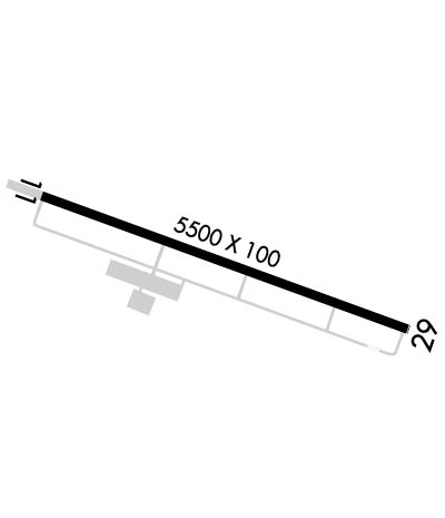
Runway Identifications
Runway Identification: 11/29
Length: 5500 ft
Width: 100 ft
Surface: ASPHALT-GOOD CONDITION
Edge lights: Medium Intensity

Treatment: NONE

 Runway: 11   Runway: 29
Mag heading: 115°Mag heading: 295°
Rwy Slope: -.23% DownRwy Slope: .23% Up
Approach: Approach: ILS/DME
Pattern: Left TrafficPattern: Left Traffic
Markings: NONPRECISION INSTRUMENTMarkings: PRECISION INSTRUMENT
Marking Condition: POOR; FADED.Marking Condition: POOR; FADED.
Arresting Dev: Arresting Dev:
Lat & Long: N3922.0  W08431.9Lat. & Long.: N3921.7  W08430.8
Elev: 631.8 ft. MSLElev: 618.9 ft. MSL
TCH: 27 ft. AGLTCH: 47 ft. AGL
Visual Glide Path: 3.50 degreesVisual Glide Path: 3.00 degrees
Displaced Threshold: NoDisplaced Threshold: No
Touchdown Zone: YESTouchdown Zone: YES
Touchdown Elev.: 631.8 feetTouchdown Elev.: 618.9 feet
Visual Glide Slope: 4-Light PAPI on LEFT side of RunwayVisual Glide Slope: 4-Light PAPI on LEFT side of Runway
RVR Equipment: RVR Equipment:
RVV Equipment: NORVV Equipment: NO
Approach Lights: Approach Lights: MALS - 1,400 foot medium intensity approach lighting system
REIL: YESREIL: YES
Centerline Lights: NOCenterline Lights: NO
Touchdown lights: NOTouchdown lights: NO
Runway Category: Runway with a Non-precision Approach having visibility minimums greater than 3/4 mileRunway Category: Precision Instrument Runway
Declared Distances: Declared Distances:
Obstructions: TREESObstructions: TREES
Marked: LIGHTEDMarked: NOT Marked/Lighted
Clearance slope: 20:1Clearance slope: 25:1
Obstruction height: 60 feet AGLObstruction height: 130 feet AGL
Dist. from runway: 1450 feetDist. from runway: 3450 feet
Centerline offset: 360 right of centerlineCenterline offset: 100 feet left of centerline
Comments: Comments:
C:34/P: