Click here for more info on on SMS!

KH70

STRATFORD FIELD
STRATFORD
TX
Time Zone: Central
Lat: N 3620.7
Long: W 10203.0
Elev: 3668
Var: -09
Longest Runway: 3023
CTAF: 122.9

FBO & Flight Services info for KH70

FBOs: Update your Fuel Prices

JAMES CRAWFORDPh: 806-396-2127
-
Freq: 122.9
Service
Jet
100LL
SAF
MoGas
Fuel Avail: NO FUEL AVAILABLE
Full        Last Update: 05/01/2024 05:53:15

Self        
If you are an FBO, call 1-203-262-1700 to update your info or email: FltPlan.Advertising@garmin.com
Advertise your FBO on FltPlan.com

Runway & Approach Info for KH70
Rwy
Length
Land Dist**
Approach*
  Rwy
Length
Land Dist**
Approach*
04
3023x32  3023'          
 
  
22
  3023x32  3023'          
 
 * only ILS, LOC, LDA, and SDF approaches to a specific runway are shown
** For any Declared Landing Distance Available, please see A/FD or Approach plates
Runway Weight Capability (lbs.) Help
Runway IDSingle WheelDouble WheelDouble Tandem WheelDual Double Wheel
04/229,000N/AN/AN/A
These numbers are Advisory and are not limits.   The Airport Manager should have more accurate Weight Limits
Approach Charts
FltPlan does not have IFR approach charts available for KH70.
Current Weather/Notams
Customs Information Send updates to Support@FltPlan.com
Customs Not Available
Database effective 05/16/2024
Airport Diagram of KH70
Airport Diagram might not be current.

Facility Name: STRATFORD FLD
City Name: STRATFORD
County: SHERMAN
State abbrev: TX
State Name: TEXAS
   
Ownership: PRIVATELY OWNED
Use: OPEN TO THE PUBLIC
Owner's Name: SKYRANCHERS INC.
Address: PO BOX 223
 STRATFORD, TX 79084
Owner's Phone: (806) 753-7866
  
Manager's Name: ROGER WELLS
Address: BOX 223
 STRATFORD, TX 79084
Phone: (806) 753-7866
   
FAA Region: SOUTHWEST
FAA Field Office: TEX


Sunrise / Sunset times for STRATFORD FLD

DateSunriseSunset
04/30/24 Tuesday6:5520:36
05/01/24 Wednesday6:5420:37
05/02/24 Thursday6:5320:38
05/03/24 Friday6:5220:38
05/04/24 Saturday6:5120:39
05/05/24 Sunday6:5020:40
05/06/24 Monday6:4920:41
05/07/24 Tuesday6:4820:42
05/08/24 Wednesday6:4720:43
05/09/24 Thursday6:4620:44
05/10/24 Friday6:4520:44
05/11/24 Saturday6:4420:45
05/12/24 Sunday6:4320:46
05/13/24 Monday6:4320:47

Airport Facilities

Airport Attendance ScheduleUNATTENDED
Airport Status OPERATIONAL (This Status can change at any time - please check NOTAMS)
Airport Lighting ScheduleACTVT LIRL RWY 04/22 5X - CTAF.
Airport Storage AvailableTie Downs, Hanger
Extra Services AvailableCrop Dusting
Wind IndicatorYES - (lighted)
Control TowerNO
CTAF Frequency122.900
Unicom Frequency
Rotating Beacon Color
Segmented CircleNO
Landing FeeNO

Airport Inspection Data

Airport InspectedSTATE - performed by PRIVATE CONTRACT PERSONNEL
Inspection Date04/07/2024

Airport Services

Type of Fuel AvailableNone
Airframe Repair ServiceNONE
Power Plant Repair ServiceNONE

Geographic Data

LatitudeN3620.7
LongitudeW10203.0 (ESTIMATED)
Arpt Elevation3668ft (SURVEYED)
Magnetic Variation09E
1 miles NEof STRATFORD
Traffic Pattern Altitude
Sectional ChartWICHITA

Aircraft Data

Operations (Reported)YearlyAvg. Daily
General Aviation Transient 1000
General Aviation Local 1600
Air Taxi 00
Commerical 00
Commuter 00
Military 00
Aircraft based on Field
General Aviation Singles 6
General Aviation Multi 0
Jet Aircraft 0
General Aviation Helicopters 0
Military Aircraft 0
Gliders 0
Ultralights 0

FAA Services

FSS on field NO
FSS tie-in FORT WORTH
FSS Phone 1-800-WX-BRIEF
Who issues Notams FTW
Notam D service at airport YES
ARTCC Name ALBUQUERQUE

Federal Status

Airport Certification
Aircraft Rescue & Firefighting IndexNone
Airport of EntryNo
Custom Landing RightsNo
Joint Civil/MilitaryNo
Military Landing rightsNo

Remarks

THIS AIRPORT HAS BEEN SURVEYED BY THE NATIONAL GEODETIC SURVEY.
SEWAGE TREATMENT PLANT LCTD SOUTH OF RWY.
(A70) EMERGENCY FUEL 100LL ONLY.
FOR CD CTC ALBUQUERQUE ARTCC AT 505-856-4861.
RWY 04/2 2 RWY 04 END, BROKEN ASPH & LOOSE STONES.
RWY 04/2 2 LIRL LCTD 33 FT FM EDGE OF PAVEMENT. NONSTD SOLAR THR LGTS.
Airport Communications & Frequencies:
CTAF Frequency:
122.900
Remarks
  • COMMUNICATIONS PRVDD BY FORT WORTH RADIO ON FREQS 122.2 (DALHART RCO).
  • Runway Identifications
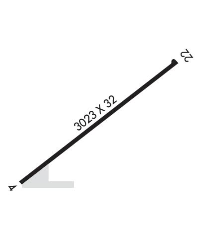
    Runway Identification: 04/22
    Length: 3023 ft
    Width: 32 ft
    Surface: ASPHALT-FAIR CONDITION
    Edge lights: Non-Standard Lighting System

    Treatment: NONE

     Runway: 04   Runway: 22
    Mag heading: 45°Mag heading: 225°
    Rwy Slope: -.53% DownRwy Slope: .53% Up
    Approach: Approach:
    Pattern: Left TrafficPattern: Left Traffic
    Markings: Markings:
    Marking Condition: RWY NOT MKD.Marking Condition: RWY NOT MKD.
    Arresting Dev: Arresting Dev:
    Lat & Long: N3620.6  W10203.2Lat. & Long.: N3620.9  W10202.7
    Elev: 3668.2 ft. MSLElev: 3652.3 ft. MSL
    TCH: TCH:
    Visual Glide Path: Visual Glide Path:
    Displaced Threshold: NoDisplaced Threshold: No
    Touchdown Zone: YESTouchdown Zone: YES
    Touchdown Elev.: 3668.2 feetTouchdown Elev.: 3668.1 feet
    Visual Glide Slope: Visual Glide Slope:
    RVR Equipment: RVR Equipment:
    RVV Equipment: NORVV Equipment: NO
    Approach Lights: Approach Lights:
    REIL: NOREIL: NO
    Centerline Lights: NOCenterline Lights: NO
    Touchdown lights: NOTouchdown lights: NO
    Runway Category: Runway with a Visual ApproachRunway Category: Runway with a Visual Approach
    Declared Distances: Declared Distances:
    Obstructions: ROAD; ALSO 35 FT. UNMKD, UNLIGHTED POLE, 325 FT DSTC, 120 FT L, APCH SLOPE 3:1.Obstructions: ROAD
    Marked: NOT Marked/LightedMarked: NOT Marked/Lighted
    Clearance slope: Clearance slope:
    Obstruction height: 15 feet AGLObstruction height: 15 feet AGL
    Dist. from runway: 200 feetDist. from runway: 200 feet
    Centerline offset: 50 right of centerlineCenterline offset: 35 feet right of centerline
    Comments: +20 FT HNGR AT THR 80 FT RIGHT CNTRLN.Comments: 15 FT ROAD 166 FT FM THR, O BOTH SIDES.
    C:/P: