Click here for more info on on SMS!

KH35

CLARKSVILLE MUNI
CLARKSVILLE
AR
Time Zone: Central
Lat: N 3528.2
Long: W 09325.6
Elev: 481
Var: -04
Longest Runway: 4504
CTAF: 122.8

FBO & Flight Services info for KH35

FBOs: Update your Fuel Prices

CLARKSVILLE MUNIPh: 479-264-8408
-
Freq: 122.8
Service
Jet
100LL
SAF
MoGas
Fuel Avail: PRIST PREMIXED. 24/7
Full        Caution: Fuel prices have not been updated in 33 days.
Last Update: 03/17/2024 14:37

Self6.895.65    
 Address: HWY 64 EAST MAIN ST   CLARKSVILLE, AR 72830
If you are an FBO, call 1-203-262-1700 to update your info or email: FltPlan.Advertising@garmin.com
Advertise your FBO on FltPlan.com

Runway & Approach Info for KH35
Rwy
Length
Land Dist**
Approach*
  Rwy
Length
Land Dist**
Approach*
09
4504x75  4504'          
 
  
27
  4504x75  4504'          
 
 * only ILS, LOC, LDA, and SDF approaches to a specific runway are shown
** For any Declared Landing Distance Available, please see A/FD or Approach plates
Runway Weight Capability (lbs.) Help
Runway IDSingle WheelDouble WheelDouble Tandem WheelDual Double Wheel
09/2719,000N/AN/AN/A
These numbers are Advisory and are not limits.   The Airport Manager should have more accurate Weight Limits
Approach Charts
Approaches    
Current Weather/Notams
Customs Information Send updates to Support@FltPlan.com
Customs Not Available
Database effective 04/18/2024
Airport Diagram of KH35
Airport Diagram might not be current.

Facility Name: CLARKSVILLE MUNI
City Name: CLARKSVILLE
County: JOHNSON
State abbrev: AR
State Name: ARKANSAS
   
Ownership: PUBLICLY OWNED
Use: OPEN TO THE PUBLIC
Owner's Name: CITY OF CLARKSVILLE
Address: 205 WALNUT
 CLARKSVILLE, AR 72830
Owner's Phone: 479-264-8408
  
Manager's Name: JIM LOONEY
Address: 205 WALNUT
 CLARKSVILLE, AR 72830
Phone: 479-264-8408; OR 479-243-6604 FOR MAINT.
   
FAA Region: SOUTHWEST
FAA Field Office: AOK


Sunrise / Sunset times for CLARKSVILLE MUNI

DateSunriseSunset
04/18/24 Thursday6:3619:50
04/19/24 Friday6:3519:51
04/20/24 Saturday6:3419:52
04/21/24 Sunday6:3319:52
04/22/24 Monday6:3119:53
04/23/24 Tuesday6:3019:54
04/24/24 Wednesday6:2919:55
04/25/24 Thursday6:2819:56
04/26/24 Friday6:2719:57
04/27/24 Saturday6:2619:57
04/28/24 Sunday6:2419:58
04/29/24 Monday6:2319:59
04/30/24 Tuesday6:2220:00
05/01/24 Wednesday6:2120:01

Airport Facilities

Airport Attendance Schedule7 Days A Week DALGT
Airport Status OPERATIONAL (This Status can change at any time - please check NOTAMS)
Airport Lighting SchedulePAPI RWY 9 & 27 OPR CONSLY; MIRL RWY 09/27 ON SS-SR.
Airport Storage AvailableTie Downs
Extra Services AvailableFlight Instruction, Parachute Jumping, Aircraft Rental
Wind IndicatorYES - (lighted)
Control TowerNO
CTAF Frequency122.800
Unicom Frequency122.800
Rotating Beacon ColorWG
Segmented CircleYES
Landing FeeNO

Airport Inspection Data

Airport InspectedSTATE - performed by STATE AERONAUTICAL PERSONNEL
Inspection Date07/27/2023

Airport Services

Type of Fuel AvailableGrade 100LL, JET A (freeze point -40C); -10SELF SRV FUEL AVBL 24 HRS WITH CREDIT CARD (100LL & JET A).
Airframe Repair ServiceMAJOR
Power Plant Repair ServiceMAJOR

Geographic Data

LatitudeN3528.2
LongitudeW09325.6 (ESTIMATED)
Arpt Elevation480ft (SURVEYED)
Magnetic Variation04E
3 miles Eof CLARKSVILLE
Traffic Pattern Altitude967
Sectional ChartMEMPHIS

Aircraft Data

Operations (Reported)YearlyAvg. Daily
General Aviation Transient 550015
General Aviation Local 700019
Air Taxi 00
Commerical 00
Commuter 00
Military 500
Aircraft based on Field
General Aviation Singles 20
General Aviation Multi 1
Jet Aircraft 0
General Aviation Helicopters 1
Military Aircraft 0
Gliders 0
Ultralights 0

FAA Services

FSS on field NO
FSS tie-in JONESBORO
FSS Phone 1-800-WX-BRIEF
Who issues Notams JBR
Notam D service at airport YES
ARTCC Name MEMPHIS

Federal Status

Airport Certification
Aircraft Rescue & Firefighting IndexNone
Airport of EntryNo
Custom Landing RightsNo
Joint Civil/MilitaryNo
Military Landing rightsYES

Federal Agreements

NATIONAL PLAN OF INTEGRATED AIRPORT SYSTEMS (NPIAS)
GRANT AGREEMENTS UNDER FAAP/ADAP/AIP
ASSURANCES PURSUANT TO TITLE VI, CIVIL RIGHTS ACT OF 1964

Remarks

WILDLIFE ON & INVOF ARPT.
FOR CD CTC MEMPHIS ARTCC AT 901-368-8453/8449.
Airport Communications & Frequencies:
CTAF Frequency:
122.800
Unicom Frequency:
122.800
Remarks
  • APCH/DEP SVC PRVDD BY MEMPHIS ARTCC ON FREQS 128.475/377.15 (RUSSELLVILLE RCAG).
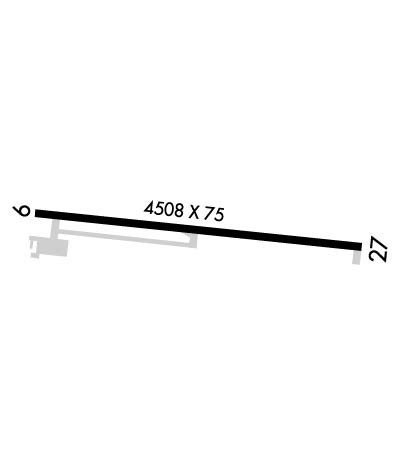
  • Runway Identifications
    Runway Identification: 09/27
    Length: 4504 ft
    Width: 75 ft
    Surface: ASPHALT
    Edge lights: Medium Intensity

    Treatment: NONE

     Runway: 09   Runway: 27
    Mag heading: 91°Mag heading: 271°
    Rwy Slope: .72% UpRwy Slope: -.72% Down
    Approach: Approach:
    Pattern: Left TrafficPattern: Left Traffic
    Markings: NONPRECISION INSTRUMENTMarkings: NONPRECISION INSTRUMENT
    Marking Condition: GOODMarking Condition: GOOD
    Arresting Dev: Arresting Dev:
    Lat & Long: N3528.3  W09326.1Lat. & Long.: N3528.2  W09325.2
    Elev: 448.4 ft. MSLElev: 480.8 ft. MSL
    TCH: 86 ft. AGLTCH: 37 ft. AGL
    Visual Glide Path: 4.00 degreesVisual Glide Path: 4.00 degrees
    Displaced Threshold: NoDisplaced Threshold: No
    Touchdown Zone: YESTouchdown Zone: YES
    Touchdown Elev.: 451.2 feetTouchdown Elev.: 480.8 feet
    Visual Glide Slope: 2-Light PAPI on LEFT side of RunwayVisual Glide Slope: 2-Light PAPI on LEFT side of Runway; PAPI UNUSBL BYD 8 DEGS RIGHT OF CNTRLN.
    RVR Equipment: RVR Equipment:
    RVV Equipment: NORVV Equipment: NO
    Approach Lights: Approach Lights:
    REIL: NOREIL: NO
    Centerline Lights: NOCenterline Lights: NO
    Touchdown lights: NOTouchdown lights: NO
    Runway Category: Runway with a Non-precision Approach having visibility minimums greater than 3/4 mileRunway Category: Runway with a Non-precision Approach having visibility minimums greater than 3/4 mile
    Declared Distances: Declared Distances:
    Obstructions: TREESObstructions: TREE
    Marked: NOT Marked/LightedMarked: NOT Marked/Lighted
    Clearance slope: 10:1Clearance slope: 11:1
    Obstruction height: 70 feet AGLObstruction height: 60 feet AGL
    Dist. from runway: 900 feetDist. from runway: 900 feet
    Centerline offset: 280 left of centerlineCenterline offset: 275 feet right of centerline
    Comments: Comments:
    C:1/P: