Current Weather/Notams (Metars, TAFs, Notams, NWS Forecast, PIREPS, and nearby weather)
Customs Information Send updates to Support@FltPlan.com
Customs Not Available
Database effective 05/16/2024
Airport Diagram might not be current.
|
| Facility Name: | ABERNATHY FLD |
| City Name: | PULASKI |
| County: | GILES |
| State abbrev: | TN |
| State Name: | TENNESSEE |
| | |
| Ownership: | PUBLICLY OWNED |
| Use: | OPEN TO THE PUBLIC |
| Owner's Name: | CITY OF PULASKI & GILES COUNTY |
| Address: | SOUTH FIRST ST PO BOX 633 |
| | PULASKI, TN 38478 |
| Owner's Phone: | 931-363-2516 |
| | |
| Manager's Name: | RANDY JONES |
| Address: | 1736 BETHEL RD |
| | PULASKI, TN 38478 |
| Phone: | 931-363-6827 |
| | |
| FAA Region: | SOUTHERN |
| FAA Field Office: | MEM |
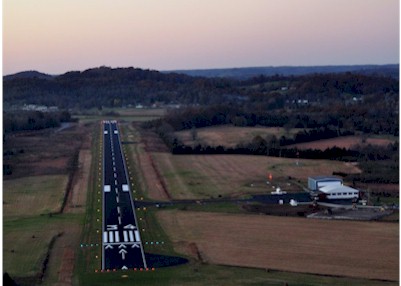
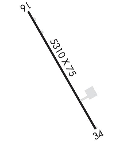
Runway Identifications
Runway Identification: 16/34Length: 5310 ft
Width: 75 ft
Surface: ASPHALT-GOOD CONDITION
Edge lights: Medium IntensityTreatment: NONE
Weight: PCN 15 /F/C/X/T
| | Runway: 16 | | Runway: 34 |
| Mag heading: | 155° | Mag heading: | 335° |
| Rwy Slope: | -.82% Down | Rwy Slope: | .82% Up |
| Approach: | | Approach: | |
| Pattern: | Left Traffic | Pattern: | Left Traffic |
| Markings: | NONPRECISION INSTRUMENT | Markings: | NONPRECISION INSTRUMENT |
| Marking Condition: | GOOD | Marking Condition: | GOOD |
| Arresting Dev: | | Arresting Dev: | |
| Lat & Long: | N3509.6 W08703.7 | Lat. & Long.: | N3508.9 W08703.2 |
| Elev: | 688.8 ft. MSL | Elev: | 645.1 ft. MSL |
| TCH: | 23 ft. AGL | TCH: | 28 ft. AGL |
| Visual Glide Path: | 3.80 degrees | Visual Glide Path: | 3.00 degrees |
| Displaced Threshold: | No | Displaced Threshold: | 300 feet |
| Touchdown Zone: | YES | Touchdown Zone: | YES |
| Touchdown Elev.: | 688.8 feet | Touchdown Elev.: | 664.9 feet |
| Visual Glide Slope: | 2-Light PAPI on LEFT side of Runway | Visual Glide Slope: | 2-Light PAPI on LEFT side of Runway |
| RVR Equipment: | | RVR Equipment: | |
| RVV Equipment: | NO | RVV Equipment: | NO |
| Approach Lights: | | Approach Lights: | |
| REIL: | YES | REIL: | YES |
| Centerline Lights: | NO | Centerline Lights: | NO |
| Touchdown lights: | NO | Touchdown lights: | NO |
| Runway Category: | Runway with a Non-precision Approach having visibility minimums greater than 3/4 mile | Runway Category: | Runway with a Non-precision Approach having visibility minimums greater than 3/4 mile |
| Declared Distances: | | Declared Distances: | |
| Obstructions: | | Obstructions: | TOWER; ROCK QUARRY TWR. |
| Marked: | | Marked: | LIGHTED |
| Clearance slope: | 34:1 | Clearance slope: | 21:1; APCH SLOPE 51:1 TO DTHR. |
| Obstruction height: | | Obstruction height: | 74 feet AGL |
| Dist. from runway: | | Dist. from runway: | 1768 feet |
| Centerline offset: | | Centerline offset: | 458 feet left of centerline |
| Comments: | | Comments: | |