Click here for more info on on SMS!

KGZH

MIDDLETON FIELD
EVERGREEN
AL
Time Zone: Central
Lat: N 3124.9
Long: W 08702.6
Elev: 259
Var: +03
Longest Runway: 5005
AWOS: 133.42
CTAF: 122.7

FBO & Flight Services info for KGZH

FBOs: Update your Fuel Prices
Middleton Field is Evergreen's very own Regional Airport. It's biggest attraction is the Southeast Regional Fly-In (SERFI). With other events and attractions, this regional airport is a must see for residents and visitors alike!
Ph: 251-578-1274 Fax: 251-578-1381 Freq: 122.7Website-
Service
Jet
100LL
SAF
MoGas
Fuel Avail: PRIST PREMIXED.. 8A-5P, 7 Days 24/7SSERV. call-out after hours
Full5.15      Last Update: 04/12/2024 14:13

Self4.655.90    
Misc. Info: Address: 355 EAST FRONT STREET,   EVERGREEN, AL 36401

AWOSPh: 251-578-1438
-
Freq: 133.42  
If you are an FBO, call 1-203-262-1700 to update your info or email: FltPlan.Advertising@garmin.com
Advertise your FBO on FltPlan.com

Runway & Approach Info for KGZH
Rwy
Length
Land Dist**
Approach*
  Rwy
Length
Land Dist**
Approach*
01
5005x150  5005'          
 
  
19
  5005x150  5005'          
 
10
5004x150  5004'          
 
  
28
  5004x150  5004'          
 
 * only ILS, LOC, LDA, and SDF approaches to a specific runway are shown
** For any Declared Landing Distance Available, please see A/FD or Approach plates
Runway Weight Capability (lbs.) Help
Runway IDSingle WheelDouble WheelDouble Tandem WheelDual Double Wheel
01/19N/AN/AN/AN/A
10/2830,00050,000N/AN/A
These numbers are Advisory and are not limits.   The Airport Manager should have more accurate Weight Limits
Approach Charts
Approaches    
Current Weather/Notams
Customs Information Send updates to Support@FltPlan.com
Customs Not Available
Database effective 05/16/2024
Airport Diagram of KGZH
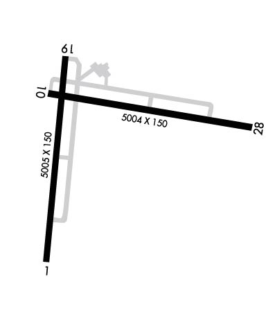
Airport Diagram might not be current.

Facility Name: EVERGREEN RGNL/MIDDLETON FLD
City Name: EVERGREEN
County: CONECUH
State abbrev: AL
State Name: ALABAMA
   
Ownership: PUBLICLY OWNED
Use: OPEN TO THE PUBLIC
Owner's Name: CITY OF EVERGREEN
Address: 355 EAST FRONT ST PO BOX 229
 EVERGREEN, AL 36401
Owner's Phone: 251-578-1574
  
Manager's Name: ANDREW ASHBURN
Address: 14134 US HWY 84 WEST
 EVERGREEN, AL 36401
Phone: 251-369-2091
   
FAA Region: SOUTHERN
FAA Field Office: JAN


Sunrise / Sunset times for EVERGREEN RGNL/MIDDLETON FLD

DateSunriseSunset
04/22/24 Monday6:1119:22
04/23/24 Tuesday6:1019:23
04/24/24 Wednesday6:0919:24
04/25/24 Thursday6:0819:24
04/26/24 Friday6:0719:25
04/27/24 Saturday6:0619:26
04/28/24 Sunday6:0519:26
04/29/24 Monday6:0419:27
04/30/24 Tuesday6:0319:28
05/01/24 Wednesday6:0219:28
05/02/24 Thursday6:0219:29
05/03/24 Friday6:0119:30
05/04/24 Saturday6:0019:30
05/05/24 Sunday5:5919:31

Airport Facilities

Airport Attendance ScheduleMON-FRI 0800-1700
Airport Status OPERATIONAL (This Status can change at any time - please check NOTAMS)
Airport Lighting ScheduleACTVT PAPI RWY 10; MIRL RWYS 01/19 & 10/28 - CTAF.
Airport Storage AvailableTie Downs, Hanger
Extra Services AvailableNONE
Wind IndicatorYES - (unlit)
Control TowerNO
CTAF Frequency122.700
Unicom Frequency122.700
Rotating Beacon ColorWG
Segmented CircleNO
Landing FeeYES

Airport Inspection Data

Airport InspectedSTATE - performed by STATE AERONAUTICAL PERSONNEL
Inspection Date08/05/2021

Airport Services

Type of Fuel AvailableGrade 100LL, JET A
Airframe Repair ServiceNone
Power Plant Repair ServiceNone

Geographic Data

LatitudeN3124.9
LongitudeW08702.6 (ESTIMATED)
Arpt Elevation259ft (SURVEYED)
Magnetic Variation03W
5 miles Wof EVERGREEN
Traffic Pattern Altitude
Sectional ChartNEW ORLEANS

Aircraft Data

Operations (Reported)YearlyAvg. Daily
General Aviation Transient 367510
General Aviation Local 23336
Air Taxi 00
Commerical 00
Commuter 00
Military 127997351
Aircraft based on Field
General Aviation Singles 10
General Aviation Multi 0
Jet Aircraft 0
General Aviation Helicopters 0
Military Aircraft 0
Gliders 0
Ultralights 0

FAA Services

FSS on field NO
FSS tie-in ANNISTON
FSS Phone 1-800-WX-BRIEF
Who issues Notams GZH
Notam D service at airport YES
ARTCC Name JACKSONVILLE

Federal Status

Airport Certification
Aircraft Rescue & Firefighting IndexNone
Airport of EntryNo
Custom Landing RightsNo
Joint Civil/MilitaryNo
Military Landing rightsYES

Federal Agreements

NATIONAL PLAN OF INTEGRATED AIRPORT SYSTEMS (NPIAS)
AGREEMENT UNDER DLAND OR DCLA HAS EXPIRED.

Remarks

INTENSIVE NAVY PROP TRNG MON-FRI SR-SS.
DIST MKRS ON BOTH SIDES OF RWYS 10/28 & 01/19 ARE US NAVY EQUIP.
TRAILER MANNED BY USN RWY DUTY OFFICER WHEN A110-01 ACTIVE. PERM USN CRASH CREW.
FOR CD CTC JACKSONVILLE ARTCC AT 904-845-1592.
FOR AFT HRS SVC CALL 251-369-2091.
Airport Communications & Frequencies:
CTAF Frequency:
122.700
Unicom Frequency:
122.700
Remarks
  • APCH/DEP SVC PRVDD BY JACKSONVILLE ARTCC ON FREQS 134.15/338.3 (CRESTVIEW RCAG).
  • Runway Identifications
    Runway Identification: 01/19
    Length: 5005 ft
    Width: 150 ft
    Surface: ASPHALT-FAIR CONDITION
    Edge lights: Medium Intensity

    Treatment: NONE

     Runway: 01   Runway: 19
    Mag heading: Mag heading: 188°
    Rwy Slope: .12% UpRwy Slope: -.12% Down
    Approach: Approach:
    Pattern: Left TrafficPattern: Left Traffic
    Markings: NONPRECISION INSTRUMENTMarkings: NONPRECISION INSTRUMENT
    Marking Condition: FAIR; MARKINGS FADED.Marking Condition: FAIR; MARKINGS FADED.
    Arresting Dev: Arresting Dev:
    Lat & Long: N3124.4  W08702.9Lat. & Long.: N3125.2  W08702.8
    Elev: 251.7 ft. MSLElev: 257.8 ft. MSL
    TCH: TCH:
    Visual Glide Path: Visual Glide Path:
    Displaced Threshold: NoDisplaced Threshold: No
    Touchdown Zone: YESTouchdown Zone: YES
    Touchdown Elev.: 253.2 feetTouchdown Elev.: 258.8 feet
    Visual Glide Slope: Visual Glide Slope:
    RVR Equipment: RVR Equipment:
    RVV Equipment: NORVV Equipment: NO
    Approach Lights: Approach Lights:
    REIL: NOREIL: NO
    Centerline Lights: NOCenterline Lights: NO
    Touchdown lights: NOTouchdown lights: NO
    Runway Category: Runway with a Non-precision Approach having visibility minimums greater than 3/4 mileRunway Category: Runway with a Non-precision Approach having visibility minimums greater than 3/4 mile
    Declared Distances: Declared Distances:
    Obstructions: Obstructions: TREE
    Marked: Marked: NOT Marked/Lighted
    Clearance slope: 34:1Clearance slope: 14:1
    Obstruction height: Obstruction height: 85 feet AGL
    Dist. from runway: Dist. from runway: 1461 feet
    Centerline offset: Centerline offset: 227 feet right of centerline
    Comments: Comments:
    Runway Identification: 10/28
    Length: 5004 ft
    Width: 150 ft
    Surface: ASPHALT-GOOD CONDITION
    Edge lights: Medium Intensity

    Treatment: NONE

     Runway: 10   Runway: 28
    Mag heading: 103°Mag heading: 283°
    Rwy Slope: -.20% DownRwy Slope: .20% Up
    Approach: Approach:
    Pattern: Left TrafficPattern: Left Traffic
    Markings: NONPRECISION INSTRUMENTMarkings: NONPRECISION INSTRUMENT
    Marking Condition: FAIR; MARKINGS FADED.Marking Condition: FAIR; MARKINGS FADED.
    Arresting Dev: Arresting Dev:
    Lat & Long: N3125.1  W08702.9Lat. & Long.: N3124.9  W08701.9
    Elev: 258.9 ft. MSLElev: 248.8 ft. MSL
    TCH: 51 ft. AGLTCH:
    Visual Glide Path: 3.00 degreesVisual Glide Path:
    Displaced Threshold: NoDisplaced Threshold: No
    Touchdown Zone: YESTouchdown Zone: YES
    Touchdown Elev.: 259.0 feetTouchdown Elev.: 248.9 feet
    Visual Glide Slope: 4-Light PAPI on LEFT side of RunwayVisual Glide Slope:
    RVR Equipment: RVR Equipment:
    RVV Equipment: NORVV Equipment: NO
    Approach Lights: Approach Lights:
    REIL: NOREIL: NO
    Centerline Lights: NOCenterline Lights: NO
    Touchdown lights: NOTouchdown lights: NO
    Runway Category: Runway with a Non-precision Approach having visibility minimums greater than 3/4 mileRunway Category: Runway with a Non-precision Approach having visibility minimums greater than 3/4 mile
    Declared Distances: Declared Distances:
    Obstructions: TREEObstructions: TREE
    Marked: NOT Marked/LightedMarked: NOT Marked/Lighted
    Clearance slope: 16:1Clearance slope: 20:1
    Obstruction height: 64 feet AGLObstruction height: 61 feet AGL
    Dist. from runway: 1233 feetDist. from runway: 1426 feet
    Centerline offset: 29 left of centerlineCenterline offset: 173 feet left of centerline
    Comments: Comments:
    C:1/P: