
| ||||||||||||||||||||||||||||||||||||||||||||
| ||||||||||||||||||||||||||||||||||||||||||||
| Rwy | Rwy | |||||||
| 8500x150 | 8500' | 8500x150 | 8500' | |||||
| Runway ID | Single Wheel | Double Wheel | Double Tandem Wheel | Dual Double Wheel |
| 03/21 | 115,000 | 225,000 | 505,000 | 985,000 |
| H1 | N/A | N/A | N/A | N/A |
| These numbers are Advisory and are not limits. The Airport Manager should have more accurate Weight Limits | ||||
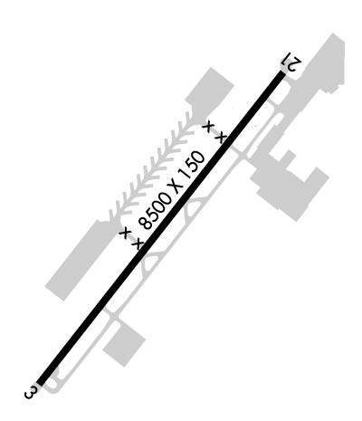 Airport Diagram might not be current. | |
| Facility Name: | PHOENIX GOODYEAR |
| City Name: | GOODYEAR |
| County: | MARICOPA |
| State abbrev: | AZ |
| State Name: | ARIZONA |
| Ownership: | PUBLICLY OWNED |
| Use: | OPEN TO THE PUBLIC |
| Owner's Name: | CITY OF PHOENIX |
| Address: | 3400 SKY HARBOR BLVD |
| PHOENIX, AZ 85034 | |
| Owner's Phone: | 602-273-3300 |
| Manager's Name: | BRADLEY HAGEN |
| Address: | 1658 SO LITCHFIELD RD, EXECUTIVE TERMINAL |
| GOODYEAR, AZ 85338 | |
| Phone: | 623-932-4550 |
| FAA Region: | WESTERN-PACIFIC |
| FAA Field Office: | PHX |

| Date | Sunrise | Sunset |
|---|---|---|
| 04/18/24 Thursday | 5:55 | 19:03 |
| 04/19/24 Friday | 5:53 | 19:04 |
| 04/20/24 Saturday | 5:52 | 19:05 |
| 04/21/24 Sunday | 5:51 | 19:05 |
| 04/22/24 Monday | 5:50 | 19:06 |
| 04/23/24 Tuesday | 5:49 | 19:07 |
| 04/24/24 Wednesday | 5:48 | 19:08 |
| 04/25/24 Thursday | 5:47 | 19:08 |
| 04/26/24 Friday | 5:46 | 19:09 |
| 04/27/24 Saturday | 5:45 | 19:10 |
| 04/28/24 Sunday | 5:43 | 19:11 |
| 04/29/24 Monday | 5:42 | 19:11 |
| 04/30/24 Tuesday | 5:41 | 19:12 |
| 05/01/24 Wednesday | 5:40 | 19:13 |
| Airport Attendance Schedule | CONTINUOUS |
| Airport Status | OPERATIONAL (This Status can change at any time - please check NOTAMS) |
| Airport Lighting Schedule | FOR MIRL RWY 03/21 OR REIL RWY 03 & 21 DURG DAYLIGHT HRS CTC ATCT OR ARPT ON 623-932-4550. AFTER SS MIRL RWY 03/21 ARE ON. PAPI RWY 03 & 21, REIL RWY 03 & 21 OPERATE CONTINUOUSLY. |
| Airport Storage Available | Tie Downs |
| Extra Services Available | Flight Instruction, Aircraft Rental |
| Wind Indicator | YES - (lighted) |
| Control Tower | YES |
| CTAF Frequency | 120.100 |
| Unicom Frequency | 122.950 |
| Rotating Beacon Color | WG |
| Segmented Circle | YES |
| Landing Fee | NO |
| Airport Inspected | STATE - performed by PRIVATE CONTRACT PERSONNEL |
| Inspection Date | 04/12/2021 |
| Type of Fuel Available | Grade 100LL, JET A (freeze point -40C) |
| Airframe Repair Service | MAJOR |
| Power Plant Repair Service | MAJOR |
| Latitude | N3325.4 |
| Longitude | W11222.5 (ESTIMATED) |
| Arpt Elevation | 969ft (SURVEYED) |
| Magnetic Variation | 10E |
| 1 miles SW | of GOODYEAR |
| Traffic Pattern Altitude | 1968(1000) LIGHT ACFT & NON-TURBO JETS; 2468(1500) HEAVY ACFT & TURBO JETS; HELICOPTERS 1468(500). |
| Sectional Chart | PHOENIX |
| Operations (Reported) | Yearly | Avg. Daily |
|---|---|---|
| General Aviation Transient | 29727 | 81 |
| General Aviation Local | 45189 | 124 |
| Air Taxi | 3324 | 9 |
| Commerical | 184 | 1 |
| Commuter | 0 | 0 |
| Military | 1175 | 3 |
| Aircraft based on Field | |
|---|---|
| General Aviation Singles | 205 |
| General Aviation Multi | 21 |
| Jet Aircraft | 16 |
| General Aviation Helicopters | 3 |
| Military Aircraft | 6 |
| Gliders | 0 |
| Ultralights | 0 |
| FSS on field | NO |
| FSS tie-in | PRESCOTT |
| FSS Phone | 1-800-WX-BRIEF |
| Who issues Notams | GYR |
| Notam D service at airport | YES |
| ARTCC Name | ALBUQUERQUE |
| Airport Certification | |
| Aircraft Rescue & Firefighting Index | None |
| Airport of Entry | No |
| Custom Landing Rights | No |
| Joint Civil/Military | No |
| Military Landing rights | YES |
| NATIONAL PLAN OF INTEGRATED AIRPORT SYSTEMS (NPIAS) |
| GRANT AGREEMENTS UNDER FAAP/ADAP/AIP |
| SURPLUS PROPERTY AGREEMENT UNDER PUBLIC LAW 289 |
| ASSURANCES PURSUANT TO TITLE VI, CIVIL RIGHTS ACT OF 1964 |
| ACFT DEP RWY 03 ASSIGNED RIGHT CROSSWIND CLIMB STRAIGHT AHEAD TO LITCHFIELD RD OR PASSING 1032 FT AGL BEFORE STARTING RIGHT TURN. |
| NMRS LARGE ACFT PARKED APRXLY 500 FT W OF RWY 03/21. |
| BIRDS INVOF ARPT. COYOTES & OTHER WILDLIFE OCNL CROSSING RWYS/TWYS. |
| WHEN TWR CLSD, TWY A BTW INT TWY A3 AND TWY A10, RSTD TO ACFT WITH WINGSPAN 118 FT OR LESS. |
| FOR CD WHEN ATCT CLSD, CTC PHOENIX APCH AT 602-306-2565. |
| NOISE SENSITIVE NEIGHBORHOOD 1-3 MILES NNE-NE OF ARPT. |
| MILITARY JET TRAFFIC 5 MILES WEST OF ARPT. |
| MOUNTAINS SE AT 6 MILES TO 4500 MSL. |
| CONTRACT TRAINING OF PILOTS FOR AIRLINES. |
| E-W PWR LINES 100 FT AGL 1/2 MILE S AER 03 UNMKD & UNLGTD SOME NSTD MARKING. |
Airport Communications & Frequencies:
| |||||||||||||||||||||||||||||||||
| Runway: 03 | Runway: 21 | ||
| Mag heading: | 28° | Mag heading: | 208° |
| Rwy Slope: | .31% Up | Rwy Slope: | -.31% Down |
| Approach: | Approach: | ||
| Pattern: | Left Traffic | Pattern: | Right Traffic |
| Markings: | PRECISION INSTRUMENT | Markings: | PRECISION INSTRUMENT |
| Marking Condition: | GOOD | Marking Condition: | GOOD |
| Arresting Dev: | Arresting Dev: | ||
| Lat & Long: | N3324.8 W11223.0 | Lat. & Long.: | N3325.9 W11222.0 |
| Elev: | 942.8 ft. MSL | Elev: | 969.1 ft. MSL |
| TCH: | 53 ft. AGL | TCH: | 53 ft. AGL |
| Visual Glide Path: | 3.00 degrees | Visual Glide Path: | 3.00 degrees |
| Displaced Threshold: | No | Displaced Threshold: | No |
| Touchdown Zone: | YES | Touchdown Zone: | YES |
| Touchdown Elev.: | 954.7 feet | Touchdown Elev.: | 969.1 feet |
| Visual Glide Slope: | 4-Light PAPI on LEFT side of Runway | Visual Glide Slope: | 4-Light PAPI on LEFT side of Runway |
| RVR Equipment: | RVR Equipment: | ||
| RVV Equipment: | NO | RVV Equipment: | NO |
| Approach Lights: | Approach Lights: | ||
| REIL: | YES | REIL: | YES |
| Centerline Lights: | NO | Centerline Lights: | NO |
| Touchdown lights: | NO | Touchdown lights: | NO |
| Runway Category: | Runway with a Non-precision Approach having visibility minimums greater than 3/4 mile | Runway Category: | Runway with a Visual Approach |
| Declared Distances: | Declared Distances: |