Current Weather/Notams (Metars, TAFs, Notams, NWS Forecast, PIREPS, and nearby weather)
Customs Information Send updates to Support@FltPlan.com
Customs Not Available
Database effective 05/16/2024
Airport Diagram might not be current. Facility Name: NORTH TEXAS RGNL/PERRIN FLD City Name: SHERMAN/DENISON County: GRAYSON State abbrev: TX State Name: TEXAS Ownership: PUBLICLY OWNED Use: OPEN TO THE PUBLIC Owner's Name: GRAYSON COUNTY Address: COUNTY COURTHOUSE SHERMAN, TX 75090 Owner's Phone: 903-813-4228 Manager's Name: BILL MAGERS Address: 4700 AIRPORT DR DENISON, TX 75020 Phone: 903-786-2904 FAA Region: SOUTHWEST FAA Field Office: TEX
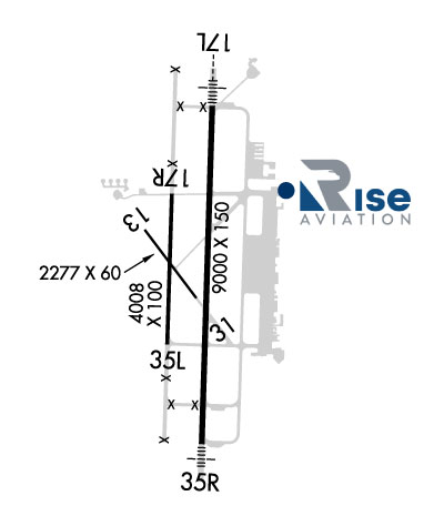
Runway Identifications Help
Runway Identification: 18L/36R Length: 9000 ftWidth: 150 ftSurface: CONCRETE ASPHALT-GOOD CONDITIONEdge lights: Medium Intensity Treatment: NONEWeight: PCN 54 /R/B/W/T Runway: 18L Runway: 36R Mag heading: 179° Mag heading: 359° Rwy Slope: .09% Up Rwy Slope: -.09% Down Approach: ILS Approach: Pattern: Left Traffic Pattern: Left Traffic Markings: PRECISION INSTRUMENT Markings: PRECISION INSTRUMENT Marking Condition: GOOD Marking Condition: GOOD Arresting Dev: Arresting Dev: Lat & Long: N3343.6 W09640.4 Lat. & Long.: N3342.1 W09640.4 Elev: 741.1 ft. MSL Elev: 748.9 ft. MSL TCH: 48 ft. AGL TCH: 51 ft. AGL Visual Glide Path: 3.00 degrees Visual Glide Path: 3.00 degrees Displaced Threshold: No Displaced Threshold: No Touchdown Zone: YES Touchdown Zone: YES Touchdown Elev.: 741.4 feet Touchdown Elev.: 749.3 feet Visual Glide Slope: 4-BOX VASI ON LEFT SIDE OF RUNWAY Visual Glide Slope: 4-BOX VASI ON LEFT SIDE OF RUNWAY RVR Equipment: RVR Equipment: RVV Equipment: NO RVV Equipment: NO Approach Lights: MALSR - 1,400 foot medium intensity approach lighting system with runway alignment indicator lights Approach Lights: MALS - 1,400 foot medium intensity approach lighting system REIL: NO REIL: NO Centerline Lights: NO Centerline Lights: NO Touchdown lights: NO Touchdown lights: NO Runway Category: Precision Instrument Runway Runway Category: D Declared Distances: Declared Distances:
Runway Identification: 18R/36L Length: 4008 ftWidth: 100 ftSurface: CONCRETE ASPHALT-FAIR CONDITIONEdge lights: Treatment: NONE Runway: 18R Runway: 36L Mag heading: 179° Mag heading: 359° Rwy Slope: .20% Up Rwy Slope: -.20% Down Approach: Approach: Pattern: Left Traffic Pattern: Left Traffic Markings: BASIC Markings: BASIC Marking Condition: FAIR Marking Condition: FAIR Arresting Dev: Arresting Dev: Lat & Long: N3343.2 W09640.6 Lat. & Long.: N3342.5 W09640.6 Elev: 738.0 ft. MSL Elev: 746.0 ft. MSL TCH: TCH: Visual Glide Path: Visual Glide Path: Displaced Threshold: No Displaced Threshold: No Touchdown Zone: YES Touchdown Zone: YES Touchdown Elev.: 738.0 feet Touchdown Elev.: 746.0 feet Visual Glide Slope: Visual Glide Slope: RVR Equipment: RVR Equipment: RVV Equipment: NO RVV Equipment: NO Approach Lights: Approach Lights: REIL: NO REIL: NO Centerline Lights: NO Centerline Lights: NO Touchdown lights: NO Touchdown lights: NO Runway Category: Runway with a Visual Approach Runway Category: Runway with a Visual Approach Declared Distances: Declared Distances: