
| ||||||||||||||||||||||||||||||||||||||||||||
| ||||||||||||||||||||||||||||||||||||||||||||
| ||||||||||||||||||||||||||||||||||||||||||||
| ||||||||||||||||||||||||||||||||||||||||||||
| ||||||||||||||||||||||||||||||||||||||||||||
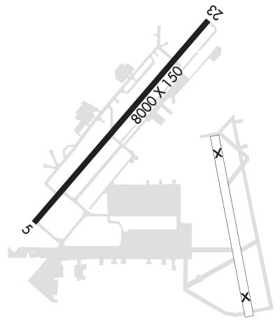
| Rwy | Rwy | |||||||
| 8000x150 | 8000' | 108.30 - 046° | 8000x150 | 8000' | ||||
| Runway ID | Single Wheel | Double Wheel | Double Tandem Wheel | Dual Double Wheel |
| 05/23 | 94,000 | 121,000 | 199,000 | N/A |
| These numbers are Advisory and are not limits. The Airport Manager should have more accurate Weight Limits | ||||
 Airport Diagram might not be current. | |
| Facility Name: | DONALDSON FLD |
| City Name: | GREENVILLE |
| County: | GREENVILLE |
| State abbrev: | SC |
| State Name: | SOUTH CAROLINA |
| Ownership: | PUBLICLY OWNED |
| Use: | OPEN TO THE PUBLIC |
| Owner's Name: | GREENVILLE CITY/COUNTY |
| Address: | 2 EXCHANGE ST |
| GREENVILLE, SC 29605 | |
| Owner's Phone: | (864) 918-8835 |
| Manager's Name: | DANNY MOYD |
| Address: | 2 EXCHANGE ST |
| GREENVILLE, SC 29605 | |
| Phone: | 864-277-3152 |
| FAA Region: | SOUTHERN |
| FAA Field Office: | ATL |
| Date | Sunrise | Sunset |
|---|---|---|
| 04/22/24 Monday | 6:48 | 20:08 |
| 04/23/24 Tuesday | 6:47 | 20:09 |
| 04/24/24 Wednesday | 6:46 | 20:10 |
| 04/25/24 Thursday | 6:45 | 20:10 |
| 04/26/24 Friday | 6:44 | 20:11 |
| 04/27/24 Saturday | 6:43 | 20:12 |
| 04/28/24 Sunday | 6:41 | 20:13 |
| 04/29/24 Monday | 6:40 | 20:14 |
| 04/30/24 Tuesday | 6:39 | 20:14 |
| 05/01/24 Wednesday | 6:38 | 20:15 |
| 05/02/24 Thursday | 6:37 | 20:16 |
| 05/03/24 Friday | 6:36 | 20:17 |
| 05/04/24 Saturday | 6:35 | 20:18 |
| 05/05/24 Sunday | 6:34 | 20:18 |
| Airport Attendance Schedule | 7 Days A Week 0600-1900 |
| Airport Status | OPERATIONAL (This Status can change at any time - please check NOTAMS) |
| Airport Lighting Schedule | ACTVT MALSR RWY 05; HIRL RWY 05/23 - CTAF. |
| Airport Storage Available | Tie Downs, Hanger |
| Extra Services Available | Cargo Handling, Charter |
| Wind Indicator | YES - (lighted) |
| Control Tower | YES |
| CTAF Frequency | 133.325 |
| Unicom Frequency | 122.700 |
| Rotating Beacon Color | WG |
| Segmented Circle | YES |
| Landing Fee | NO |
| Airport Inspected | FEDERAL - performed by FAA AIRPORTS FIELD PERSONNEL |
| Inspection Date | 01/13/2023 |
| Type of Fuel Available | Grade 100LL, JET A (freeze point -40C) |
| Airframe Repair Service | MAJOR |
| Power Plant Repair Service | MAJOR |
| Latitude | N3445.5 |
| Longitude | W08222.6 (ESTIMATED) |
| Arpt Elevation | 955ft (SURVEYED) |
| Magnetic Variation | 07W |
| 6 miles S | of GREENVILLE |
| Traffic Pattern Altitude | 1800 |
| Sectional Chart | ATLANTA |
| Operations (Reported) | Yearly | Avg. Daily |
|---|---|---|
| General Aviation Transient | 17130 | 47 |
| General Aviation Local | 22093 | 61 |
| Air Taxi | 11368 | 31 |
| Commerical | 0 | 0 |
| Commuter | 0 | 0 |
| Military | 4052 | 11 |
| Aircraft based on Field | |
|---|---|
| General Aviation Singles | 30 |
| General Aviation Multi | 7 |
| Jet Aircraft | 3 |
| General Aviation Helicopters | 1 |
| Military Aircraft | 12 |
| Gliders | 0 |
| Ultralights | 1 |
| FSS on field | NO |
| FSS tie-in | ANDERSON |
| FSS Phone | 1-800-WX-BRIEF |
| Who issues Notams | GYH |
| Notam D service at airport | YES |
| ARTCC Name | ATLANTA |
| Airport Certification | CLSD TO ACR OPNS WITH MORE THAN 30 PSGR SEATS EXCP 24 HR PPR CALL AMGR 864-277-3152. |
| Aircraft Rescue & Firefighting Index | AIRPORT HAS A CERTIFICATE UNDER CFR PART 139 |
| Airport of Entry | No |
| Custom Landing Rights | No |
| Joint Civil/Military | No |
| Military Landing rights | YES |
| NATIONAL PLAN OF INTEGRATED AIRPORT SYSTEMS (NPIAS) |
| GRANT AGREEMENTS UNDER FAAP/ADAP/AIP |
| ASSURANCES PURSUANT TO TITLE VI, CIVIL RIGHTS ACT OF 1964 |
| LTD PRK, RAMP CLSD TO ALL TFC EXC MIL R/W ACFT WITH 24HR PPR. CTC ARNG OPS C803-299-5214. OPR 1230-2200Z++ MON-FRI, EXC HOL. LTD TRAN MAINT FOR CH47 AND UH72 ACFT ONLY. |
| ARNG OPS PTD - 41.3 308.7 REMARKS: ARNG OPS C803-299-5214 (GREENVILLE OPS). |
| TWY A CLSD TO WINGSPANS GTR THAN 79 FT WO PRIOR CDN WITH ARPT MGMT. |
| SFC CONDS NOT RPRTD DAILY 9PM TO 7AM LOCAL. |
Airport Communications & Frequencies:
| |||||||||||||||||||||||||
| Runway: 05 | Runway: 23 | ||
| Mag heading: | 47° | Mag heading: | 227° |
| Rwy Slope: | -.46% Down | Rwy Slope: | .46% Up |
| Approach: | ILS/DME | Approach: | |
| Pattern: | Right Traffic | Pattern: | Left Traffic |
| Markings: | PRECISION INSTRUMENT | Markings: | PRECISION INSTRUMENT |
| Marking Condition: | GOOD | Marking Condition: | GOOD |
| Arresting Dev: | BAK-14; BAK-14 (1502 FT). | Arresting Dev: | BAK-14; BAK-14 (1703 FT). |
| Lat & Long: | N3445.0 W08223.1 | Lat. & Long.: | N3446.0 W08222.1 |
| Elev: | 955.8 ft. MSL | Elev: | 918.9 ft. MSL |
| TCH: | 56 ft. AGL | TCH: | 95 ft. AGL |
| Visual Glide Path: | 3.22 degrees | Visual Glide Path: | 4.14 degrees |
| Displaced Threshold: | No | Displaced Threshold: | No |
| Touchdown Zone: | YES | Touchdown Zone: | YES |
| Touchdown Elev.: | 955.9 feet | Touchdown Elev.: | 938.0 feet |
| Visual Glide Slope: | 4-Light PAPI on LEFT side of Runway | Visual Glide Slope: | 4-Light PAPI on LEFT side of Runway |
| RVR Equipment: | RVR Equipment: | ||
| RVV Equipment: | NO | RVV Equipment: | NO |
| Approach Lights: | MALSR - 1,400 foot medium intensity approach lighting system with runway alignment indicator lights | Approach Lights: | |
| REIL: | NO | REIL: | NO |
| Centerline Lights: | NO | Centerline Lights: | NO |
| Touchdown lights: | NO | Touchdown lights: | NO |
| Runway Category: | Precision Instrument Runway | Runway Category: | Runway with a Non-precision Approach having visibility minimums greater than 3/4 mile |
| Declared Distances: | Declared Distances: | ||
| Obstructions: | Obstructions: | TREES | |
| Marked: | Marked: | NOT Marked/Lighted | |
| Clearance slope: | 50:1 | Clearance slope: | 33:1 |
| Obstruction height: | Obstruction height: | 42 feet AGL | |
| Dist. from runway: | Dist. from runway: | 1600 feet | |
| Centerline offset: | Centerline offset: | 650 feet left of centerline | |
| Comments: | Comments: |
