Click here for more info on on SMS!

KGYB

GIDDINGS-LEE COUNTY
GIDDINGS
TX
Time Zone: Central
Lat: N 3010.2
Long: W 09658.8
Elev: 484
Var: -06
Longest Runway: 4000
AWOS: 119.22
CTAF: 123.05

FBO & Flight Services info for KGYB

FBOs: Update your Fuel Prices

SILLS AVIATIONPh: 979-542-6081
-
-
Service
Jet
100LL
SAF
MoGas
Fuel Avail: Jet A w/prist is available upon request.
Full        Last Update: 04/19/2024 07:23

Self5.685.30    
 Address: 1234 COUNTY RD 206   GIDDINGS, TX 78942
AWOSPh: 979-542-0382
-
Freq: 119.22  
If you are an FBO, call 1-203-262-1700 to update your info or email: FltPlan.Advertising@garmin.com
Advertise your FBO on FltPlan.com

Runway & Approach Info for KGYB
Rwy
Length
Land Dist**
Approach*
  Rwy
Length
Land Dist**
Approach*
17
4000x75  4000'          
 
  
35
  4000x75  4000'          
 
 * only ILS, LOC, LDA, and SDF approaches to a specific runway are shown
** For any Declared Landing Distance Available, please see A/FD or Approach plates
Runway Weight Capability (lbs.) Help
Runway IDSingle WheelDouble WheelDouble Tandem WheelDual Double Wheel
17/3512,500N/AN/AN/A
These numbers are Advisory and are not limits.   The Airport Manager should have more accurate Weight Limits
Approach Charts
Approaches    
Current Weather/Notams
Customs Information Send updates to Support@FltPlan.com
Customs Not Available
Database effective 05/16/2024
Airport Diagram of KGYB
Airport Diagram might not be current.

Facility Name: GIDDINGS-LEE COUNTY
City Name: GIDDINGS
County: LEE
State abbrev: TX
State Name: TEXAS
   
Ownership: PUBLICLY OWNED
Use: OPEN TO THE PUBLIC
Owner's Name: CITY OF GIDDINGS & LEE CO
Address: 118 E RICHMOND
 GIDDINGS, TX 78942
Owner's Phone: 979-540-2710
  
Manager's Name: JOSEPH SILLS
Address: 1234 CR 206
 GIDDINGS, TX 78942
Phone: 979-542-6081; MGR CELL 512-470-1466.
   
FAA Region: SOUTHWEST
FAA Field Office: TEX


Sunrise / Sunset times for GIDDINGS-LEE COUNTY

DateSunriseSunset
04/24/24 Wednesday6:5120:02
04/25/24 Thursday6:5020:02
04/26/24 Friday6:4920:03
04/27/24 Saturday6:4820:04
04/28/24 Sunday6:4720:04
04/29/24 Monday6:4620:05
04/30/24 Tuesday6:4520:05
05/01/24 Wednesday6:4420:06
05/02/24 Thursday6:4320:07
05/03/24 Friday6:4220:07
05/04/24 Saturday6:4220:08
05/05/24 Sunday6:4120:09
05/06/24 Monday6:4020:09
05/07/24 Tuesday6:3920:10

Airport Facilities

Airport Attendance ScheduleMON-FRI 0900-1800
Airport Status OPERATIONAL (This Status can change at any time - please check NOTAMS)
Airport Lighting ScheduleSS-SR
Airport Storage AvailableTie Downs
Extra Services AvailableNONE
Wind IndicatorYES - (lighted)
Control TowerNO
CTAF Frequency123.050
Unicom Frequency123.050
Rotating Beacon ColorWG
Segmented CircleYES
Landing FeeNO

Airport Inspection Data

Airport InspectedSTATE - performed by PRIVATE CONTRACT PERSONNEL
Inspection Date05/22/2023

Airport Services

Type of Fuel AvailableGrade 100LL, JET A (freeze point -40C); -10100LL & JET A 24 HR SELF SERVE.
Airframe Repair ServiceMAJOR
Power Plant Repair ServiceMAJOR

Geographic Data

LatitudeN3010.2
LongitudeW09658.8 (ESTIMATED)
Arpt Elevation484ft (SURVEYED)
Magnetic Variation06E
3 miles Wof GIDDINGS
Traffic Pattern Altitude
Sectional ChartHOUSTON

Aircraft Data

Operations (Reported)YearlyAvg. Daily
General Aviation Transient 430012
General Aviation Local 870024
Air Taxi 00
Commerical 00
Commuter 00
Military 2001
Aircraft based on Field
General Aviation Singles 31
General Aviation Multi 2
Jet Aircraft 0
General Aviation Helicopters 0
Military Aircraft 0
Gliders 0
Ultralights 2

FAA Services

FSS on field NO
FSS tie-in MONTGOMERY COUNTY
FSS Phone 1-800-WX-BRIEF
Who issues Notams GYB
Notam D service at airport YES
ARTCC Name HOUSTON

Federal Status

Airport Certification
Aircraft Rescue & Firefighting IndexNone
Airport of EntryNo
Custom Landing RightsNo
Joint Civil/MilitaryNo
Military Landing rightsNo

Federal Agreements

NATIONAL PLAN OF INTEGRATED AIRPORT SYSTEMS (NPIAS)

Remarks

DEER ON & INVOF ARPT.
FOR CD CTC AUSTIN APCH AT 512-369-7865.
Airport Communications & Frequencies:
CTAF Frequency:
123.050
Unicom Frequency:
123.050
AUSTIN Primary Approach Frequencies:  
127.225
317.65
AUSTIN Primary Departure Frequencies:  
127.225
317.65
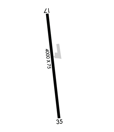
Runway Identifications
Runway Identification: 17/35
Length: 4000 ft
Width: 75 ft
Surface: ASPHALT-GOOD CONDITION
Edge lights: Medium Intensity

Treatment: NONE

 Runway: 17   Runway: 35
Mag heading: 168°Mag heading: 348°
Rwy Slope: -1.13% DownRwy Slope: 1.13% Up
Approach: Approach:
Pattern: Left TrafficPattern: Left Traffic
Markings: NONPRECISION INSTRUMENTMarkings: NONPRECISION INSTRUMENT
Marking Condition: GOODMarking Condition: GOOD
Arresting Dev: Arresting Dev:
Lat & Long: N3010.5  W09658.8Lat. & Long.: N3009.8  W09658.8
Elev: 484.1 ft. MSLElev: 439.1 ft. MSL
TCH: 34 ft. AGLTCH: 45 ft. AGL
Visual Glide Path: 3.75 degreesVisual Glide Path: 3.40 degrees
Displaced Threshold: NoDisplaced Threshold: No
Touchdown Zone: YESTouchdown Zone: YES
Touchdown Elev.: 484.1 feetTouchdown Elev.: 472.6 feet
Visual Glide Slope: 2-Light PAPI on LEFT side of RunwayVisual Glide Slope: 2-Light PAPI on LEFT side of Runway
RVR Equipment: RVR Equipment:
RVV Equipment: NORVV Equipment: NO
Approach Lights: Approach Lights:
REIL: NOREIL: NO
Centerline Lights: NOCenterline Lights: NO
Touchdown lights: NOTouchdown lights: NO
Runway Category: Runway with a Non-precision ApproachRunway Category: Runway with a Non-precision Approach
Declared Distances: Declared Distances:
Obstructions: TREESObstructions: TREES
Marked: NOT Marked/LightedMarked: NOT Marked/Lighted
Clearance slope: 7:1Clearance slope: 12:1
Obstruction height: 44 feet AGLObstruction height: 46 feet AGL
Dist. from runway: 520 feetDist. from runway: 760 feet
Centerline offset: 260 left of centerlineCenterline offset:
Comments: 5 FT FENCE, 0-77 FT DSTC, 222 FT L.Comments:
C:1/P: