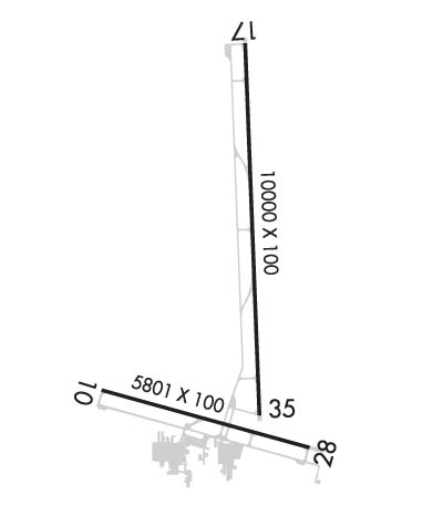
Click here for more info on on SMS!

KGXY

GREELEY-WELD COUNTY
GREELEY
CO
Time Zone: Mountain
Lat: N 4026.2
Long: W 10438.0
Elev: 4697
Var: -08
Longest Runway: 10000
Clr Del: 126.65
AWOS: 135.17
CTAF: 122.8

FBO & Flight Services info for KGXY

FBOs: Update your Fuel Prices

PEAK FLT SUPPORTPh: 970-336-3010 Fax: 970-336-3011 Freq: 122.85
Service
Jet
100LL
SAF
MoGas
Fuel Avail: PRIST PREMIXED. (Price changes every Thursday)
Full6.957.35    Last Update: 04/19/2024 15:00

Self  6.20    
 Address: 600 AIRPORT ROAD UNIT C, TERMINAL BLDG   GREELEY, CO 80631
AWOSPh: 970-352-3511
-
Freq: 135.17  
If you are an FBO, call 1-203-262-1700 to update your info or email: FltPlan.Advertising@garmin.com
Advertise your FBO on FltPlan.com

Runway & Approach Info for KGXY
Rwy
Length
Land Dist**
Approach*
  Rwy
Length
Land Dist**
Approach*
10
5801x100  5801'          
 
  
28
  5801x100  5801'          
 
17
10000x100  10000'          
 
  
35
  10000x100  8900'          
ILS/DME
 110.30 - 349°  
 * only ILS, LOC, LDA, and SDF approaches to a specific runway are shown
** For any Declared Landing Distance Available, please see A/FD or Approach plates
Runway Weight Capability (lbs.) Help
Runway IDSingle WheelDouble WheelDouble Tandem WheelDual Double Wheel
10/2818,00030,000N/AN/A
17/3530,00045,000N/AN/A
H1N/AN/AN/AN/A
H2N/AN/AN/AN/A
These numbers are Advisory and are not limits.   The Airport Manager should have more accurate Weight Limits
Approach Charts
Approaches    
Current Weather/Notams
Customs Information Send updates to Support@FltPlan.com
Customs Not Available
Database effective 05/16/2024
Airport Diagram of KGXY
Airport Diagram might not be current.

Facility Name: GREELEY-WELD COUNTY
City Name: GREELEY
County: WELD
State abbrev: CO
State Name: COLORADO
   
Ownership: PUBLICLY OWNED
Use: OPEN TO THE PUBLIC
Owner's Name: GREELEY-WELD CO ARPT AUTH
Address: PO BOX 727
 GREELEY, CO 80632
Owner's Phone: 970-336-3000
  
Manager's Name: COOPER ANDERSON
Address: PO BOX 727
 GREELEY, CO 80632
Phone: (970) 336-3001
   
FAA Region: NORTHWEST MOUNTAIN
FAA Field Office: DEN


Sunrise / Sunset times for GREELEY-WELD COUNTY

DateSunriseSunset
04/24/24 Wednesday6:0619:48
04/25/24 Thursday6:0519:49
04/26/24 Friday6:0319:50
04/27/24 Saturday6:0219:51
04/28/24 Sunday6:0119:52
04/29/24 Monday5:5919:53
04/30/24 Tuesday5:5819:54
05/01/24 Wednesday5:5719:55
05/02/24 Thursday5:5519:56
05/03/24 Friday5:5419:57
05/04/24 Saturday5:5319:58
05/05/24 Sunday5:5219:59
05/06/24 Monday5:5120:00
05/07/24 Tuesday5:5020:01

Airport Facilities

Airport Attendance Schedule7 Days A Week 0600-1900; PREARRANGE AFTER HOURS AIRPORT ACCESS WITH FBO'S. CALL 970-336-4866 OR 970-351-8957.
Airport Status OPERATIONAL (This Status can change at any time - please check NOTAMS)
Airport Lighting ScheduleACTVT MIRL RYS 10/28 & 17/35, & REIL RYS 10, 28, 17, & 35 - CTAF. PAPI RYS 10, 17, 35, & VASI RY 28 OPR 24 HRS.
Airport Storage AvailableTie Downs, Hanger
Extra Services AvailableCrop Dusting, Air Ambulance, Charter, Flight Instruction, Aircraft Rental
Wind IndicatorYES - (lighted)
Control TowerNO
CTAF Frequency122.800
Unicom Frequency122.800
Rotating Beacon ColorWG
Segmented CircleYES
Landing FeeNO

Airport Inspection Data

Airport InspectedSTATE - performed by STATE AERONAUTICAL PERSONNEL
Inspection Date05/19/2022

Airport Services

Type of Fuel AvailableGrade 100LL, JET A (freeze point -40C)
Airframe Repair ServiceMAJOR
Power Plant Repair ServiceMAJOR

Geographic Data

LatitudeN4026.2
LongitudeW10438.0 (ESTIMATED)
Arpt Elevation4696ft (SURVEYED)
Magnetic Variation08E
3 miles Eof GREELEY
Traffic Pattern Altitude800
Sectional ChartCHEYENNE

Aircraft Data

Operations (Reported)YearlyAvg. Daily
General Aviation Transient 44064121
General Aviation Local 66096181
Air Taxi 00
Commerical 00
Commuter 00
Military 5001
Aircraft based on Field
General Aviation Singles 125
General Aviation Multi 16
Jet Aircraft 6
General Aviation Helicopters 3
Military Aircraft 0
Gliders 0
Ultralights 0

FAA Services

FSS on field NO
FSS tie-in DENVER
FSS Phone 1-800-WX-BRIEF
Who issues Notams GXY
Notam D service at airport YES
ARTCC Name DENVER

Federal Status

Airport Certification
Aircraft Rescue & Firefighting IndexNone
Airport of EntryNo
Custom Landing RightsNo
Joint Civil/MilitaryNo
Military Landing rightsYES

Federal Agreements

NATIONAL PLAN OF INTEGRATED AIRPORT SYSTEMS (NPIAS)
GRANT AGREEMENTS UNDER FAAP/ADAP/AIP
ASSURANCES PURSUANT TO TITLE VI, CIVIL RIGHTS ACT OF 1964

Remarks

THIS AIRPORT HAS BEEN SURVEYED BY THE NATIONAL GEODETIC SURVEY.
RY 17/35 PREFERRED USE WHEN CROSS WIND COMPONENT EXCEEDS 12 KT ON RY 10/28.
RWY 35 PREFERRED USE WHEN WIND LESS THAN 5 KNOTS. RY 35 PREFERRED FOR TGL.
WILDLIFE AND BRIDS ON & INVOF APRT.
OIL DRILLING RIGS UP TO 120 FT AGL ON AND INVICINTY OF AIRPORT.
BE ALERT; INTENSIVE USAF STUDENT TRAINING IN VICINITY OF COLORADO SPRINGS & PUEBLO COLORADO.
ACFT DEPG RWY28 AVOID SB TURN PRIOR TO XNG RWY10 THLD.
Airport Communications & Frequencies:
Clearance Delivery Frequencies:
126.65
CTAF Frequency:
122.800
Unicom Frequency:
122.800
Remarks
  • COMMUNICATIONS PRVDD BY DENVER RADIO ON FREQ 122.5 (GILL RCO).
  • DENVER Primary Approach Frequencies:  
    134.85
    251.125
    DENVER Primary Departure Frequencies:  
    134.85
    251.125
    Runway Identifications
    Runway Identification: 10/28
    Length: 5801 ft
    Width: 100 ft
    Surface: ASPHALT-GOOD CONDITION
    Edge lights: Medium Intensity

    Treatment: NONE

     Runway: 10   Runway: 28
    Mag heading: 97°Mag heading: 277°
    Rwy Slope: -.28% DownRwy Slope: .28% Up
    Approach: Approach:
    Pattern: Left TrafficPattern: Right Traffic
    Markings: PRECISION INSTRUMENTMarkings: PRECISION INSTRUMENT
    Marking Condition: GOODMarking Condition: GOOD
    Arresting Dev: Arresting Dev:
    Lat & Long: N4025.8  W10438.8Lat. & Long.: N4025.6  W10437.6
    Elev: 4661.2 ft. MSLElev: 4644.8 ft. MSL
    TCH: 43 ft. AGLTCH: 27 ft. AGL
    Visual Glide Path: 3.00 degreesVisual Glide Path: 3.00 degrees
    Displaced Threshold: NoDisplaced Threshold: No
    Touchdown Zone: YESTouchdown Zone: YES
    Touchdown Elev.: 4661.2 feetTouchdown Elev.: 4649.8 feet
    Visual Glide Slope: 2-Light PAPI on LEFT side of RunwayVisual Glide Slope: 4-BOX VASI ON LEFT SIDE OF RUNWAY
    RVR Equipment: RVR Equipment:
    RVV Equipment: NORVV Equipment: NO
    Approach Lights: Approach Lights:
    REIL: YESREIL: YES
    Centerline Lights: NOCenterline Lights: NO
    Touchdown lights: NOTouchdown lights: NO
    Runway Category: Runway with a Non-precision Approach having visibility minimums greater than 3/4 mileRunway Category: Runway with a Non-precision Approach having visibility minimums greater than 3/4 mile
    Declared Distances: Declared Distances:
    Obstructions: Obstructions: POLE
    Marked: Marked: NOT Marked/Lighted
    Clearance slope: 34:1Clearance slope: 47:1
    Obstruction height: Obstruction height: 27 feet AGL
    Dist. from runway: Dist. from runway: 1485 feet
    Centerline offset: Centerline offset: 144 feet left of centerline
    Comments: +10 FT DIRT ACCESS ROAD AT THLD & PARALLEL TO EXTDD CNTRLN; +9 FT CROPS 140 FT FM THLD 90 FT L & R OF CNTRLN.Comments:
    Runway Identification: 17/35
    Length: 10000 ft
    Width: 100 ft
    Surface: ASPHALT-GOOD CONDITION
    Edge lights: Medium Intensity

    Treatment: NONE

     Runway: 17   Runway: 35
    Mag heading: 169°Mag heading: 349°
    Rwy Slope: -.48% DownRwy Slope: .48% Up
    Approach: Approach: ILS/DME
    Pattern: Left TrafficPattern: Left Traffic
    Markings: PRECISION INSTRUMENTMarkings: PRECISION INSTRUMENT
    Marking Condition: GOODMarking Condition: GOOD
    Arresting Dev: Arresting Dev:
    Lat & Long: N4027.4  W10437.9Lat. & Long.: N4025.7  W10437.9
    Elev: 4696.8 ft. MSLElev: 4648.5 ft. MSL
    TCH: 46 ft. AGLTCH: 51 ft. AGL
    Visual Glide Path: 3.00 degreesVisual Glide Path: 3.00 degrees
    Displaced Threshold: NoDisplaced Threshold: 1100 feet
    Touchdown Zone: YESTouchdown Zone: YES
    Touchdown Elev.: 4696.8 feetTouchdown Elev.: 4664.8 feet
    Visual Glide Slope: 2-Light PAPI on LEFT side of RunwayVisual Glide Slope: 2-Light PAPI on LEFT side of Runway
    RVR Equipment: RVR Equipment:
    RVV Equipment: NORVV Equipment: NO
    Approach Lights: Approach Lights:
    REIL: YESREIL: YES
    Centerline Lights: NOCenterline Lights: NO
    Touchdown lights: NOTouchdown lights: NO
    Runway Category: Runway with a Visual ApproachRunway Category: Precision Instrument Runway
    Declared Distances: Declared Distances:
    Obstructions: TREEObstructions:
    Marked: NOT Marked/LightedMarked:
    Clearance slope: 47:1Clearance slope: 50:1
    Obstruction height: 56 feet AGLObstruction height:
    Dist. from runway: 2834 feetDist. from runway:
    Centerline offset: 514 right of centerlineCenterline offset:
    Comments: Comments:
    Runway Identification: H1 HELIPAD
    Length: 20 ft
    Width: 20 ft
    Surface: CONCRETE-GOOD CONDITION
    Edge lights:

    Treatment: NONE

    Runway Identification: H2 HELIPAD
    Length: 20 ft
    Width: 20 ft
    Surface: CONCRETE-GOOD CONDITION
    Edge lights:

    Treatment: NONE

    C:27/P: