
| |||||||||||||||||||||||||||||||||||||||||||||||||||||||||||||
| |||||||||||||||||||||||||||||||||||||||||||||||||||||||||||||
| |||||||||||||||||||||||||||||||||||||||||||||||||||||||||||||
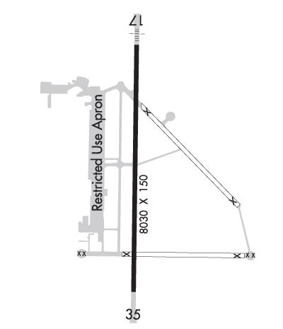
| Rwy | Rwy | |||||||
| 8030x150 | 8030' | 110.50 - 175° | 8030x150 | 8030' | ||||
| Runway ID | Single Wheel | Double Wheel | Double Tandem Wheel | Dual Double Wheel |
| 17/35 | 26,000 | N/A | N/A | N/A |
| These numbers are Advisory and are not limits. The Airport Manager should have more accurate Weight Limits | ||||
 Airport Diagram might not be current. | |
| Facility Name: | MAJORS |
| City Name: | GREENVILLE |
| County: | HUNT |
| State abbrev: | TX |
| State Name: | TEXAS |
| Ownership: | PUBLICLY OWNED |
| Use: | OPEN TO THE PUBLIC |
| Owner's Name: | CITY OF GREENVILLE |
| Address: | 2821 WASHINGTON STREET, P O BOX 1049 |
| GREENVILLE, TX 75403 | |
| Owner's Phone: | 903-457-3116 |
| Manager's Name: | TY HELTON |
| Address: | GREENVILLE MUNICIPAL AIRPORT, 101 MAJORS RD |
| GREENVILLE, TX 75401 | |
| Phone: | 903-457-3168; THELTON@CI.GREENVILLE.TX.US ALT PHONE 214-960-9294 |
| FAA Region: | SOUTHWEST |
| FAA Field Office: | TEX |
| Date | Sunrise | Sunset |
|---|---|---|
| 04/18/24 Thursday | 6:50 | 19:57 |
| 04/19/24 Friday | 6:49 | 19:58 |
| 04/20/24 Saturday | 6:48 | 19:59 |
| 04/21/24 Sunday | 6:46 | 20:00 |
| 04/22/24 Monday | 6:45 | 20:00 |
| 04/23/24 Tuesday | 6:44 | 20:01 |
| 04/24/24 Wednesday | 6:43 | 20:02 |
| 04/25/24 Thursday | 6:42 | 20:03 |
| 04/26/24 Friday | 6:41 | 20:03 |
| 04/27/24 Saturday | 6:40 | 20:04 |
| 04/28/24 Sunday | 6:39 | 20:05 |
| 04/29/24 Monday | 6:38 | 20:06 |
| 04/30/24 Tuesday | 6:37 | 20:06 |
| 05/01/24 Wednesday | 6:36 | 20:07 |
| Airport Attendance Schedule | FRI-SAT 0730-1800, SUN-THU 0730-1700 |
| Airport Status | OPERATIONAL (This Status can change at any time - please check NOTAMS) |
| Airport Lighting Schedule | ACTVT MALS RWY 17; REIL RWY 35; MIRL RWY 17/35 - CTAF. |
| Airport Storage Available | Tie Downs |
| Extra Services Available | Air Ambulance, Flight Instruction |
| Wind Indicator | YES - (lighted) |
| Control Tower | YES |
| CTAF Frequency | 118.650 |
| Unicom Frequency | 122.950 |
| Rotating Beacon Color | WG |
| Segmented Circle | YES |
| Landing Fee | NO |
| Airport Inspected | STATE - performed by PRIVATE CONTRACT PERSONNEL |
| Inspection Date | 11/03/2023 |
| Type of Fuel Available | Grade 100LL, JET A (freeze point -40C); -10100LL SELF SVC AVBL 24 HRS. |
| Airframe Repair Service | MINOR |
| Power Plant Repair Service | MINOR |
| Latitude | N3304.1 |
| Longitude | W09603.9 (ESTIMATED) |
| Arpt Elevation | 534ft (SURVEYED) |
| Magnetic Variation | 05E |
| 4 miles SE | of GREENVILLE |
| Traffic Pattern Altitude | |
| Sectional Chart | DALLAS-FT WORTH |
| Operations (Reported) | Yearly | Avg. Daily |
|---|---|---|
| General Aviation Transient | 8640 | 24 |
| General Aviation Local | 12960 | 36 |
| Air Taxi | 0 | 0 |
| Commerical | 0 | 0 |
| Commuter | 0 | 0 |
| Military | 400 | 1 |
| Aircraft based on Field | |
|---|---|
| General Aviation Singles | 34 |
| General Aviation Multi | 4 |
| Jet Aircraft | 3 |
| General Aviation Helicopters | 1 |
| Military Aircraft | 0; NMRS MIL ACFT ON FLD FOR MODIFICATION. |
| Gliders | 0 |
| Ultralights | 0 |
| FSS on field | NO |
| FSS tie-in | FORT WORTH |
| FSS Phone | 1-800-WX-BRIEF |
| Who issues Notams | GVT |
| Notam D service at airport | YES |
| ARTCC Name | FORT WORTH |
| Airport Certification | |
| Aircraft Rescue & Firefighting Index | None |
| Airport of Entry | No |
| Custom Landing Rights | No |
| Joint Civil/Military | No |
| Military Landing rights | YES |
| NATIONAL PLAN OF INTEGRATED AIRPORT SYSTEMS (NPIAS) |
| GRANT AGREEMENTS UNDER FAAP/ADAP/AIP |
| SURPLUS PROPERTY AGREEMENT UNDER PUBLIC LAW 289 |
| SURPLUS PROPERTY AGREEMENT UNDER REGULATION 16-WAA |
| ASSURANCES PURSUANT TO TITLE VI, CIVIL RIGHTS ACT OF 1964 |
| AGREEMENT UNDER DLAND OR DCLA HAS EXPIRED. |
| WHEN ATCT CLSD AND THERE IS AN EMERG OR INCIDENT ON ARPT, CTC 903-457-5333. |
| ACFT NOT VSB FM OPPOSITE END OF RWY. |
| MILITARY USE: JASU - 1(B-10) 1(B-10A) 1(MD-3) 1(MA-1) 1(MA-3). |
| 89 FT HIGH INTST RADIO FREQ ANT 3700 FT EAST OF RWY 35 AT END OF ABNDD PAVEMENT. |
| TWY E LGTS 47 FT FM PAVEMENT EDGE. |
| TWY A CLSD. |
| PPR FOR PAJA ONTO MAJORS FIELD. |
| WHEN ATCT CLSD, FOR CD CTC FORT WORTH ARTCC AT 817-858-7584. |
Airport Communications & Frequencies:
| |||||||||||||||||||||
| Runway: 17 | Runway: 35 | ||
| Mag heading: | 176° | Mag heading: | 356° |
| Rwy Slope: | .06% Up | Rwy Slope: | -.06% Down |
| Approach: | ILS/DME | Approach: | |
| Pattern: | Left Traffic | Pattern: | Left Traffic |
| Markings: | PRECISION INSTRUMENT | Markings: | NONPRECISION INSTRUMENT |
| Marking Condition: | GOOD | Marking Condition: | GOOD |
| Arresting Dev: | Arresting Dev: | ||
| Lat & Long: | N3304.7 W09603.9 | Lat. & Long.: | N3303.4 W09603.9 |
| Elev: | 519.6 ft. MSL | Elev: | 524.3 ft. MSL |
| TCH: | 74 ft. AGL | TCH: | 66 ft. AGL |
| Visual Glide Path: | 3.00 degrees | Visual Glide Path: | 3.00 degrees |
| Displaced Threshold: | No | Displaced Threshold: | No |
| Touchdown Zone: | YES | Touchdown Zone: | YES |
| Touchdown Elev.: | 533.7 feet | Touchdown Elev.: | 531.6 feet |
| Visual Glide Slope: | 4-Light PAPI on LEFT side of Runway | Visual Glide Slope: | 4-Light PAPI on LEFT side of Runway |
| RVR Equipment: | RVR Equipment: | ||
| RVV Equipment: | NO | RVV Equipment: | NO |
| Approach Lights: | MALS - 1,400 foot medium intensity approach lighting system | Approach Lights: | |
| REIL: | NO | REIL: | YES |
| Centerline Lights: | NO | Centerline Lights: | NO |
| Touchdown lights: | NO | Touchdown lights: | NO |
| Runway Category: | Precision Instrument Runway | Runway Category: | Runway with a Non-precision Approach having visibility minimums greater than 3/4 mile |
| Declared Distances: | Declared Distances: | ||
| Obstructions: | TREES | Obstructions: | TREES |
| Marked: | NOT Marked/Lighted | Marked: | NOT Marked/Lighted |
| Clearance slope: | 7:1 | Clearance slope: | 22:1 |
| Obstruction height: | 18 feet AGL | Obstruction height: | 34 feet AGL |
| Dist. from runway: | 337 feet | Dist. from runway: | 955 feet |
| Centerline offset: | 140 right of centerline | Centerline offset: | |
| Comments: | Comments: |

