Current Weather/Notams (Metars, TAFs, Notams, NWS Forecast, PIREPS, and nearby weather)
Customs Information Send updates to Support@FltPlan.com
Customs Not Available
Database effective 05/16/2024
Airport Diagram might not be current.
|
| Facility Name: | GORDONSVILLE MUNI |
| City Name: | GORDONSVILLE |
| County: | ORANGE |
| State abbrev: | VA |
| State Name: | VIRGINIA |
| | |
| Ownership: | PUBLICLY OWNED |
| Use: | OPEN TO THE PUBLIC |
| Owner's Name: | TOWN OF GORDONSVILLE |
| Address: | P.O. BOX 276 |
| | GORDONSVILLE, VA 22942 |
| Owner's Phone: | 540-832-2233 |
| | |
| Manager's Name: | DEBORAH S. KENDALL, TOWN MGR |
| Address: | PO BOX 276 |
| | GORDONSVILLE, VA 22942 |
| Phone: | (540) 832-2233 |
| | |
| FAA Region: | EASTERN |
| FAA Field Office: | DCA |
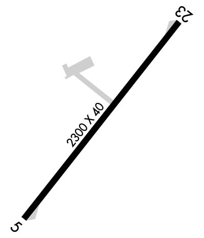
Runway Identifications
Runway Identification: 05/23Length: 2300 ft
Width: 40 ft
Surface: ASPHALT
Edge lights: Medium IntensityTreatment: NONE
| | Runway: 05 | | Runway: 23 |
| Mag heading: | 48° | Mag heading: | 228° |
| Rwy Slope: | -.48% Down | Rwy Slope: | .48% Up |
| Approach: | | Approach: | |
| Pattern: | Left Traffic | Pattern: | Left Traffic |
| Markings: | BASIC | Markings: | BASIC |
| Marking Condition: | GOOD | Marking Condition: | GOOD |
| Arresting Dev: | | Arresting Dev: | |
| Lat & Long: | N3809.2 W07810.1 | Lat. & Long.: | N3809.5 W07809.8 |
| Elev: | 453.0 ft. MSL | Elev: | 442.0 ft. MSL |
| TCH: | | TCH: | |
| Visual Glide Path: | | Visual Glide Path: | |
| Displaced Threshold: | No | Displaced Threshold: | 440 feet |
| Touchdown Zone: | YES | Touchdown Zone: | YES |
| Touchdown Elev.: | 453.0 feet | Touchdown Elev.: | 453.0 feet |
| Visual Glide Slope: | SYSTEM OF PANELS ON RIGHT SIDE OF RUNWAY (May NOT Be Lighted) | Visual Glide Slope: | SYSTEM OF PANELS ON RIGHT SIDE OF RUNWAY (May NOT Be Lighted) |
| RVR Equipment: | | RVR Equipment: | |
| RVV Equipment: | NO | RVV Equipment: | NO |
| Approach Lights: | | Approach Lights: | |
| REIL: | NO | REIL: | NO |
| Centerline Lights: | NO | Centerline Lights: | NO |
| Touchdown lights: | NO | Touchdown lights: | NO |
| Runway Category: | Runway with a Visual Approach | Runway Category: | Runway with a Visual Approach |
| Declared Distances: | | Declared Distances: | |
| Obstructions: | TREE | Obstructions: | TREE |
| Marked: | NOT Marked/Lighted | Marked: | NOT Marked/Lighted |
| Clearance slope: | 1:1 | Clearance slope: | 4:1 |
| Obstruction height: | 11 feet AGL | Obstruction height: | 77 feet AGL |
| Dist. from runway: | 217 feet | Dist. from runway: | 567 feet |
| Centerline offset: | 46 left of centerline | Centerline offset: | 130 feet right of centerline |
| Comments: | | Comments: | LINE OF TREES 120 FT S OF RWY CNTRLN. |

