Current Weather/Notams (Metars, TAFs, Notams, NWS Forecast, PIREPS, and nearby weather)
Customs Information Send updates to Support@FltPlan.com
Customs Not Available
Database effective 05/16/2024
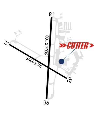
Airport Diagram might not be current. Facility Name: GEORGETOWN EXEC City Name: GEORGETOWN County: WILLIAMSON State abbrev: TX State Name: TEXAS Ownership: PUBLICLY OWNED Use: OPEN TO THE PUBLIC Owner's Name: CITY OF GEORGETOWN Address: PO BOX 409 GEORGETOWN, TX 78627 Owner's Phone: (512) 930-3666 Manager's Name: MATTHEW SOMMERFELD Address: 500 TERMINAL DRIVE GEORGETOWN, TX 78628 Phone: 512-930-8464; EMERG 512-930-8464. FAA Region: SOUTHWEST FAA Field Office: TEX
Runway Identifications Help
Runway Identification: 11/29 Length: 4099 ftWidth: 75 ftSurface: ASPHALT-FAIR CONDITIONEdge lights: Medium Intensity Treatment: NONE Runway: 11 Runway: 29 Mag heading: 115° Mag heading: 295° Rwy Slope: -.75% Down Rwy Slope: .75% Up Approach: Approach: Pattern: Left Traffic Pattern: Right Traffic Markings: NONPRECISION INSTRUMENT Markings: NONPRECISION INSTRUMENT Marking Condition: GOOD Marking Condition: GOOD Arresting Dev: Arresting Dev: Lat & Long: N3040.9 W09741.2 Lat. & Long.: N3040.5 W09740.5 Elev: 789.4 ft. MSL Elev: 758.7 ft. MSL TCH: TCH: Visual Glide Path: Visual Glide Path: Displaced Threshold: No Displaced Threshold: No Touchdown Zone: YES Touchdown Zone: YES Touchdown Elev.: 789.5 feet Touchdown Elev.: 777.3 feet Visual Glide Slope: Visual Glide Slope: RVR Equipment: RVR Equipment: RVV Equipment: NO RVV Equipment: NO Approach Lights: Approach Lights: REIL: NO REIL: NO Centerline Lights: NO Centerline Lights: NO Touchdown lights: NO Touchdown lights: NO Runway Category: Runway with a Non-precision Approach Runway Category: Runway with a Non-precision Approach Declared Distances: Declared Distances: Obstructions: TREE Obstructions: TREE Marked: NOT Marked/Lighted Marked: NOT Marked/Lighted Clearance slope: 29:1 Clearance slope: Obstruction height: 42 feet AGL Obstruction height: 30 feet AGL Dist. from runway: 1425 feet Dist. from runway: 210 feet Centerline offset: 212 left of centerline Centerline offset: 214 feet left of centerline Comments: Comments: 8 FT FENCE 199 FT DSTC, 246 FT L.
Runway Identification: 18/36 Length: 5004 ftWidth: 100 ftSurface: ASPHALT-GOOD CONDITIONEdge lights: Medium Intensity Treatment: GROOVED Runway: 18 Runway: 36 Mag heading: 178° Mag heading: 358° Rwy Slope: -.76% Down Rwy Slope: .76% Up Approach: Approach: Pattern: Left Traffic Pattern: Right Traffic Markings: NONPRECISION INSTRUMENT Markings: NONPRECISION INSTRUMENT Marking Condition: GOOD Marking Condition: GOOD Arresting Dev: Arresting Dev: Lat & Long: N3041.2 W09740.7 Lat. & Long.: N3040.3 W09740.7 Elev: 785.7 ft. MSL Elev: 747.5 ft. MSL TCH: 35 ft. AGL TCH: 50 ft. AGL Visual Glide Path: 3.00 degrees Visual Glide Path: 3.00 degrees Displaced Threshold: No Displaced Threshold: No Touchdown Zone: YES Touchdown Zone: YES Touchdown Elev.: 785.7 feet Touchdown Elev.: 764.5 feet Visual Glide Slope: 4-Light PAPI on LEFT side of Runway Visual Glide Slope: 4-Light PAPI on LEFT side of Runway RVR Equipment: RVR Equipment: RVV Equipment: NO RVV Equipment: NO Approach Lights: Approach Lights: REIL: YES REIL: YES Centerline Lights: NO Centerline Lights: NO Touchdown lights: NO Touchdown lights: NO Runway Category: Runway with a Non-precision Approach having visibility minimums greater than 3/4 mile Runway Category: Runway with a Non-precision Approach having visibility minimums greater than 3/4 mile Declared Distances: Declared Distances: Obstructions: TREES Obstructions: TREES Marked: NOT Marked/Lighted Marked: NOT Marked/Lighted Clearance slope: 30:1 Clearance slope: 28:1 Obstruction height: 37 feet AGL Obstruction height: 34 feet AGL Dist. from runway: 1320 feet Dist. from runway: 1170 feet Centerline offset: 69 right of centerline Centerline offset: 30 feet right of centerline Comments: Comments: