Current Weather/Notams (Metars, TAFs, Notams, NWS Forecast, PIREPS, and nearby weather)
Customs Information Send updates to Support@FltPlan.com
Customs Not Available
Database effective 04/18/2024
Airport Diagram might not be current.
|
| Facility Name: | GRANTSBURG MUNI |
| City Name: | GRANTSBURG |
| County: | BURNETT |
| State abbrev: | WI |
| State Name: | WISCONSIN |
| | |
| Ownership: | PUBLICLY OWNED |
| Use: | OPEN TO THE PUBLIC |
| Owner's Name: | VILLAGE OF GRANTSBURG |
| Address: | 316 S. BRAD ST |
| | GRANTSBURG, WI 54840 |
| Owner's Phone: | 715-463-2405 |
| | |
| Manager's Name: | SHEILA MEYER |
| Address: | 316 S. BRAD ST; EMAIL ADDRESS: PUBLICWORKS@GRANTSBURGWI.COM (ALL LOWER CASE) |
| | GRANTSBURG, WI 54840 |
| Phone: | 715-463-2405 |
| | |
| FAA Region: | GREAT LAKES |
| FAA Field Office: | CHI |
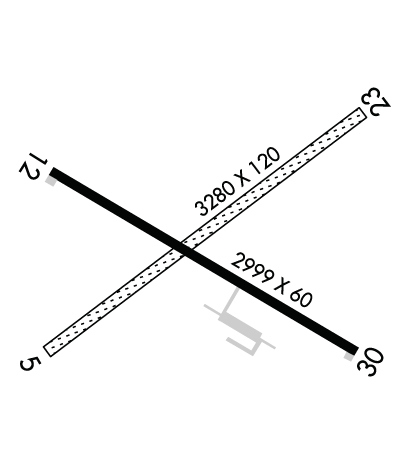
Runway Identifications
Runway Identification: 05/23Length: 3280 ft
Width: 120 ft
Surface: GRASS-FAIR CONDITION
Edge lights: Treatment: NONE
| | Runway: 05 | | Runway: 23 |
| Mag heading: | 56° | Mag heading: | 236° |
| Rwy Slope: | .00% Up | Rwy Slope: | .00% Down |
| Approach: | | Approach: | |
| Pattern: | Left Traffic | Pattern: | Left Traffic |
| Markings: | | Markings: | |
| Marking Condition: | RWY 05/23 MKD WITH YELLOW CONES. | Marking Condition: | |
| Arresting Dev: | | Arresting Dev: | |
| Lat & Long: | N4547.8 W09240.2 | Lat. & Long.: | N4548.1 W09239.5 |
| Elev: | 924.1 ft. MSL | Elev: | 924.2 ft. MSL |
| TCH: | | TCH: | |
| Visual Glide Path: | | Visual Glide Path: | |
| Displaced Threshold: | No | Displaced Threshold: | No |
| Touchdown Zone: | YES | Touchdown Zone: | YES |
| Touchdown Elev.: | 927.1 feet | Touchdown Elev.: | 927.1 feet |
| Visual Glide Slope: | | Visual Glide Slope: | |
| RVR Equipment: | | RVR Equipment: | |
| RVV Equipment: | NO | RVV Equipment: | NO |
| Approach Lights: | | Approach Lights: | |
| REIL: | NO | REIL: | NO |
| Centerline Lights: | NO | Centerline Lights: | NO |
| Touchdown lights: | NO | Touchdown lights: | NO |
| Runway Category: | Runway with a Visual Approach | Runway Category: | Runway with a Visual Approach |
| Declared Distances: | | Declared Distances: | |
| Obstructions: | | Obstructions: | TREES |
| Marked: | | Marked: | NOT Marked/Lighted |
| Clearance slope: | 20:1 | Clearance slope: | 17:1 |
| Obstruction height: | | Obstruction height: | 29 feet AGL |
| Dist. from runway: | | Dist. from runway: | 500 feet |
| Centerline offset: | | Centerline offset: | 90 feet right of centerline |
| Comments: | | Comments: | |
Runway Identification: 12/30Length: 2999 ft
Width: 60 ft
Surface: ASPHALT-POOR CONDITION
Edge lights: Medium IntensityTreatment: NONE
| | Runway: 12 | | Runway: 30 |
| Mag heading: | 121° | Mag heading: | 301° |
| Rwy Slope: | -.02% Down | Rwy Slope: | .02% Up |
| Approach: | | Approach: | |
| Pattern: | Left Traffic | Pattern: | Left Traffic |
| Markings: | NONPRECISION INSTRUMENT | Markings: | NONPRECISION INSTRUMENT |
| Marking Condition: | POOR; MARKINGS FADED. | Marking Condition: | POOR; MARKINGS FADED. |
| Arresting Dev: | | Arresting Dev: | |
| Lat & Long: | N4548.0 W09240.2 | Lat. & Long.: | N4547.8 W09239.6 |
| Elev: | 924.2 ft. MSL | Elev: | 923.6 ft. MSL |
| TCH: | | TCH: | |
| Visual Glide Path: | | Visual Glide Path: | |
| Displaced Threshold: | No | Displaced Threshold: | No |
| Touchdown Zone: | YES | Touchdown Zone: | YES |
| Touchdown Elev.: | 926.7 feet | Touchdown Elev.: | 926.7 feet |
| Visual Glide Slope: | | Visual Glide Slope: | |
| RVR Equipment: | | RVR Equipment: | |
| RVV Equipment: | NO | RVV Equipment: | NO |
| Approach Lights: | | Approach Lights: | |
| REIL: | NO | REIL: | NO |
| Centerline Lights: | NO | Centerline Lights: | NO |
| Touchdown lights: | NO | Touchdown lights: | NO |
| Runway Category: | Runway with a Non-precision Approach | Runway Category: | Runway with a Non-precision Approach |
| Declared Distances: | | Declared Distances: | |
| Obstructions: | TREES | Obstructions: | TREES |
| Marked: | NOT Marked/Lighted | Marked: | NOT Marked/Lighted |
| Clearance slope: | 8:1 | Clearance slope: | 12:1 |
| Obstruction height: | 15 feet AGL | Obstruction height: | 40 feet AGL |
| Dist. from runway: | 330 feet | Dist. from runway: | 700 feet |
| Centerline offset: | 225 left of centerline | Centerline offset: | 300 feet left of centerline |
| Comments: | | Comments: | |

