Click here for more info on on SMS!

KGTB

WHEELER-SACK AAF (PRIVATE)
FORT DRUM
NY
Time Zone: Eastern
Lat: N 4403.3
Long: W 07543.2
Elev: 690
Var: +13
Longest Runway: 10000
Clr Del: 121.9
Dept. ATIS: 119.52
Arr. ATIS: 119.52
Ground: 121.9
Tower: 118.75

FBO & Flight Services info for KGTB

FBOs: Update your Fuel Prices

US ARMY- PRIVATE
-
-

If you are an FBO, call 1-203-262-1700 to update your info or email: FltPlan.Advertising@garmin.com
Advertise your FBO on FltPlan.com

Runway & Approach Info for KGTB
Rwy
Length
Land Dist**
Approach*
  Rwy
Length
Land Dist**
Approach*
03
10000x150  8637'          
ILS/DME
 108.50 - 029°  
  
21
  10000x150  10000'          
ILS/DME
 108.50 - 209°  
08
4501x150  4501'          
 
  
26
  4501x150  4501'          
 
15
5002x144  5002'          
 
  
33
  5002x144  5002'          
 
 * only ILS, LOC, LDA, and SDF approaches to a specific runway are shown
** For any Declared Landing Distance Available, please see A/FD or Approach plates
Runway Weight Capability (lbs.) Help
Runway IDSingle WheelDouble WheelDouble Tandem WheelDual Double Wheel
03/21N/AN/AN/AN/A
08/26N/AN/AN/AN/A
15/33N/AN/AN/AN/A
These numbers are Advisory and are not limits.   The Airport Manager should have more accurate Weight Limits
Approach Charts
Approaches    
Current Weather/Notams
Customs Information Send updates to Support@FltPlan.com
Customs Not Available
Database effective 05/16/2024
Airport Diagram of KGTB
Airport Diagram might not be current.

Facility Name: WHEELER-SACK AAF
City Name: FORT DRUM
County: JEFFERSON
State abbrev: NY
State Name: NEW YORK
   
Ownership: ARMY OWNED
Use: PRIVATE
Owner's Name: US ARMY AERONAUTICAL SVCS AGENCY
Address:
 FORT BELVOIR, VA 22060
Owner's Phone:
  
Manager's Name:
Address:
 
Phone:
   
FAA Region: EASTERN
FAA Field Office: NYC


Sunrise / Sunset times for WHEELER-SACK AAF

DateSunriseSunset
04/22/24 Monday6:0719:56
04/23/24 Tuesday6:0519:58
04/24/24 Wednesday6:0419:59
04/25/24 Thursday6:0220:00
04/26/24 Friday6:0120:01
04/27/24 Saturday5:5920:02
04/28/24 Sunday5:5820:04
04/29/24 Monday5:5620:05
04/30/24 Tuesday5:5520:06
05/01/24 Wednesday5:5320:07
05/02/24 Thursday5:5220:08
05/03/24 Friday5:5120:10
05/04/24 Saturday5:4920:11
05/05/24 Sunday5:4820:12

Airport Facilities

Airport Attendance ScheduleMON-FRI 0700-2200; OTR TIMES PPR. ARPT CLSD HOLS.
Airport Status OPERATIONAL (This Status can change at any time - please check NOTAMS)
Airport Lighting ScheduleSS-SR
Airport Storage AvailableNONE
Extra Services AvailableNONE
Wind IndicatorNONE
Control TowerYES
CTAF Frequency
Unicom Frequency
Rotating Beacon ColorSWG; LCTD ON 847'MSL TOWER WEST OF RWY 8.
Segmented CircleNO
Landing Fee

Airport Inspection Data

Airport InspectedNo Inspection Data Available performed by the OWNER
Inspection DateUnknown

Airport Services

Type of Fuel AvailableNone
Airframe Repair ServiceNone
Power Plant Repair ServiceNone

Geographic Data

LatitudeN4403.3
LongitudeW07543.2 (ESTIMATED)
Arpt Elevation689ft (SURVEYED)
Magnetic Variation13W
1 miles NEof FORT DRUM
Traffic Pattern AltitudeR/W 1400 FT, F/W 2000 FT TURBO JET 2500 FT, OVERHEAD 3000 FT.
Sectional ChartMONTREAL

Aircraft Data

Operations (Reported)YearlyAvg. Daily
General Aviation Transient 00
General Aviation Local 00
Air Taxi 00
Commerical 00
Commuter 00
Military 00
Aircraft based on Field
General Aviation Singles 0
General Aviation Multi 0
Jet Aircraft 0
General Aviation Helicopters 0
Military Aircraft 0
Gliders 0
Ultralights 0

FAA Services

FSS on field NO
FSS tie-in BURLINGTON
FSS Phone 1-800-WX-BRIEF
Who issues Notams GTB
Notam D service at airport YES
ARTCC Name BOSTON

Federal Status

Airport Certification
Aircraft Rescue & Firefighting IndexNone
Airport of EntryNo
Custom Landing RightsNo
Joint Civil/MilitaryNo
Military Landing rightsNo

Remarks

SERVICE-L-AOE JASU-3(ASU600-270-DDP). FUEL-A++ (MIL); AVBL 1400-0300Z++MON-FRI, EXC HOL, OT PN.
MISC: WX SVC AVBL 24/7. DSN 772-6065, C315-772-6065. BACK-UP WX BRIEF AVBL FR 15 OWS SCOTT AFB DSN 576-9755/9702, C618-256-9755/9702. PRI WX SENSORS AUTOMATED H24. DRG AUGMENTATION/BACK-UP WX OBSERVATION PT IS OBST 033 DEGS-162 DEGS. PMSV FREQ NOT MONITORED SAT, SUN, AND FEDERAL HOL.
NS ABTMT - QUIET HRS 0300-1100Z++.
CUST/AG/IMG: 24 HR PN, CONSULT FCG. AERIAL PORT MSN ACFT PLAN ARR BTN 1300-0300Z++ MON-FRI EXC HOL, OT RQR ADVANCED COORD AND APVL.
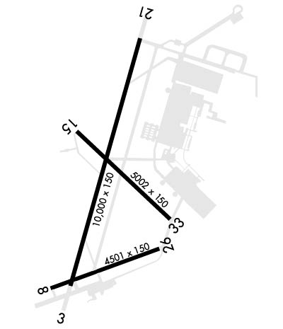
RWY 03/21 ACLT STOP AND TKOF RUN DIST AVBL 10000 FT.
TFC PAT - R/W 1400 FT, F/W 2000 FT. TURBO JET 2500 FT. OVHD 3000 FT.
TWY G RSTD TO C130 OR SMALLER, MAX ACN 25.
SECTION OF RWY 08/26 BTN RWY 03/21 AND TWY D RATED CONC PCN 54 R/B/W/T.
TRAN ALERT: NO CATERING, CLEANING, LAV, TRASH REMOVAL, WATER, OR CREW TRNSP SVC AVBL.
BASE OPS OPR 1200-0400Z++ MON-FRI; CLSD SAT, SUN AND FEDERAL HOL. ALL TRAN ACFT INBD FOR PRK CTC BASE OPS 20 MIN PRIOR TO LDG, MIL AIRCREWS MUST REGISTER WITH BASE OPS IF RON. TRAN R/W PRK SOUTH END OF NORTH RAMP. TWY G, N, P, R AND TWY L EAST OF TWY B DESIGNATED NONMOVEMENT AREA. ACFT INBD FOR AVN FLD MAINT ACT (AFMA) MUST ARR NO LATER THAN 1900Z++ CTC DSN 772-7536 C315-772-7536. EMERG CTC MT OPS CNTR DSN 772-8620 C315-772-8620.
FLUID - SP DE-ICE TYPE I AND IV AVBL WITH 3 HR PN.
RSTD: PPR CTC BASE OPS DSN 772-5681 C315-772-5681/5682. TENANT ACFT HAVE PRIORITY FOR LCL PAT OPS, TRAN MAY BE LTD. RWY 15-33.TWY G RSTD TO C130 OR SMALLER. SOD LDG/OPS RSTD TO CNTR, SOD. OASIS RST TO TENANT R/W HOT REFUL OPS, LDG/DEP PROHIBITED WHEN CLSD. OASIS 4R/22L CLSD N OF POINT 4, DEP 4R LDG, 22L PROHIBITED. TWY B BTN TWY A AND N RAMP CLSD.
CTN: EXTSY MIL ACFT ACTIVITY VCNTY ARPT MIL ACFT REFER TO FLIP AP/1 PRIOR TO OPS ON FORT DRUM OR WI R-5201. NARROW TWY A,B INT ARC 40 FT WIDE. N RAMP EDGE LGT US. TWY B EDGE LGT US BTN TWY A AND SABRE HELIPAD. W RAMP UNLGTD. OASIS 22/04 THLD/END LGT US. RSC NOT MNTN WHEN BASE OPS IS CLSD. WILDLIFE HAZ, REFER TO AP/1.
RWY 08/2 6 RWY 08/26 CNTR 75 FT CONC BTN RWY 03 AND TWY D, PCN 54, REMAINDER ASPH.
Airport Communications & Frequencies:
ATIS Frequencies:   Hours(local) of Operation:
119.525
WHEELER-SACK Tower Frequencies:   Hours(local) of operation: CONTINUOUS   
118.75
290.25
49.8FM
WHEELER-SACK Ground Frequencies:
121.9
229.8
Clearance Delivery Frequencies:
121.9
Remarks
  • 344.6 PMSV AVBL THRU GRIFFISS AFB.
  • ATCT-ARAC.
  • WHEELER-SACK Primary Approach Frequencies:   Hours(local) of operation: CONTINUOUS   
    124.875
    257.6
    307.125
    WHEELER-SACK Primary Departure Frequencies:   Hours(local) of operation: CONTINUOUS   
    124.875
    257.6
    307.125
    Runway Identifications
    Runway Identification: 03/21
    Length: 10000 ft
    Width: 150 ft
    Surface: CONCRETE-GOOD CONDITION
    Edge lights: High Intensity

    Treatment: NONE
    Weight: PCN 59 /R/B/W/T

     Runway: 03   Runway: 21
    Mag heading: N/AMag heading: N/A
    Rwy Slope: -.19% DownRwy Slope: .19% Up
    Approach: ILS/DMEApproach: ILS/DME
    Pattern: Left TrafficPattern: Right Traffic
    Markings: PRECISION INSTRUMENTMarkings: PRECISION INSTRUMENT
    Marking Condition: GOODMarking Condition: GOOD
    Arresting Dev: Arresting Dev:
    Lat & Long: N4402.7  W07543.5Lat. & Long.: N4404.3  W07542.9
    Elev: 679.3 ft. MSLElev: 660.5 ft. MSL
    TCH: 64 ft. AGLTCH: 72 ft. AGL
    Visual Glide Path: 3.00 degreesVisual Glide Path: 3.00 degrees
    Displaced Threshold: 1363 feetDisplaced Threshold: No
    Touchdown Zone: YESTouchdown Zone: YES
    Touchdown Elev.: 685.4 feetTouchdown Elev.: 677.3 feet
    Visual Glide Slope: 4-Light PAPI on LEFT side of RunwayVisual Glide Slope: 4-Light PAPI on LEFT side of Runway
    RVR Equipment: TOUCHDOWN-ROLLOUTRVR Equipment: TOUCHDOWN-ROLLOUT
    RVV Equipment: NORVV Equipment: NO
    Approach Lights: ALSF1 - standard 2,400 foot high intensity approach lighting system with sequenced flashers, Category IApproach Lights: ALSF1 - standard 2,400 foot high intensity approach lighting system with sequenced flashers, Category I
    REIL: NOREIL: NO
    Centerline Lights: NOCenterline Lights: NO
    Touchdown lights: NOTouchdown lights: NO
    Runway Category: Runway Category:
    Declared Distances: Declared Distances:
    Runway Identification: 08/26
    Length: 4501 ft
    Width: 150 ft
    Surface: CONCRETE ASPHALT
    Edge lights: Low Intensity

    Treatment: NONE
    Weight: PCN 34 /F/A/W/T

     Runway: 08   Runway: 26
    Mag heading: N/AMag heading: N/A
    Rwy Slope: .22% UpRwy Slope: -.22% Down
    Approach: Approach:
    Pattern: Right TrafficPattern: Left Traffic
    Markings: BASICMarkings: BASIC
    Marking Condition: POORMarking Condition: POOR
    Arresting Dev: Arresting Dev:
    Lat & Long: N4402.7  W07543.7Lat. & Long.: N4403.0  W07542.8
    Elev: 675.3 ft. MSLElev: 685.4 ft. MSL
    TCH: TCH:
    Visual Glide Path: Visual Glide Path:
    Displaced Threshold: NoDisplaced Threshold: No
    Touchdown Zone: YESTouchdown Zone: YES
    Touchdown Elev.: 683.4 feetTouchdown Elev.: 685.4 feet
    Visual Glide Slope: Visual Glide Slope:
    RVR Equipment: RVR Equipment:
    RVV Equipment: NORVV Equipment: NO
    Approach Lights: Approach Lights:
    REIL: NOREIL: NO
    Centerline Lights: NOCenterline Lights: NO
    Touchdown lights: NOTouchdown lights: NO
    Runway Category: Runway Category:
    Declared Distances: Declared Distances:
    Runway Identification: 15/33
    Length: 5002 ft
    Width: 144 ft
    Surface: CONCRETE
    Edge lights: High Intensity

    Treatment: NONE
    Weight: PCN 43 /R/C/W/T

     Runway: 15   Runway: 33
    Mag heading: N/AMag heading: N/A
    Rwy Slope: .48% UpRwy Slope: -.48% Down
    Approach: Approach:
    Pattern: Right TrafficPattern: Left Traffic
    Markings: PRECISION INSTRUMENTMarkings: PRECISION INSTRUMENT
    Marking Condition: POORMarking Condition: POOR
    Arresting Dev: Arresting Dev:
    Lat & Long: N4403.7  W07543.5Lat. & Long.: N4403.1  W07542.7
    Elev: 665.9 ft. MSLElev: 689.9 ft. MSL
    TCH: TCH:
    Visual Glide Path: Visual Glide Path:
    Displaced Threshold: NoDisplaced Threshold: No
    Touchdown Zone: YESTouchdown Zone: YES
    Touchdown Elev.: 687.1 feetTouchdown Elev.: 689.9 feet
    Visual Glide Slope: Visual Glide Slope:
    RVR Equipment: TOUCHDOWN-ROLLOUTRVR Equipment: TOUCHDOWN-ROLLOUT
    RVV Equipment: NORVV Equipment: NO
    Approach Lights: MALSR - 1,400 foot medium intensity approach lighting system with runway alignment indicator lightsApproach Lights:
    REIL: NOREIL: NO
    Centerline Lights: NOCenterline Lights: NO
    Touchdown lights: NOTouchdown lights: NO
    Runway Category: Runway Category:
    Declared Distances: Declared Distances:
    C:2/P: