KGSO

PIEDMONT TRIAD INTL
GREENSBORO
NC
Time Zone: Eastern
Lat: N 3606.1
Long: W 07956.5
Elev: 926
Var: +08
Longest Runway: 10001
Clr Del: 121.75
Dept. ATIS: 128.55
Arr. ATIS: 128.55
Ground: 121.9
Tower: 119.1

FBO & Flight Services info for KGSO

FBOs: Update your Fuel Prices

  click here  
New FBO at KGSO, off of A-2, to make two FBO's on the field again!
All basic services with room to grow. Heated hangar space up to a G-4, upon availability. Quick access to NC68 (1 minute) and I-40 (2 minutes) to restaurants, hotels and High Point (20 minutes).
Ph: 866-947-6564 Fax: 336-279-7999 Freq: 128.90WebsiteE-Mail
                     
Service
Jet
100LL
SAF
MoGas
Full7.386.82999.99  Last Update: 04/16/2024 10:51

Self        
Misc. Info: Sustainable Aviation Jet Fuel (SAF) is not available at Koury Aviation at this time.Address: 7680 AIRLINE ROAD   GREENSBORO, NC 27409

SIGNATUREPh: 336-668-0481 Fax: 336-668-7862 Freq: 130.57
Service
Jet
100LL
SAF
MoGas
Fuel Avail: Jet A w/Prist, add $0.08 per gallon.
Full7.387.09    Last Update: 04/18/2024 12:04  
Self  6.09    
 Address: 1060 PTI DRIVE   GREENSBORO, NC 27409
ASOSPh: 336-393-0168
-
-
 
If you are an FBO, call 1-203-262-1700 to update your info or email: FltPlan.Advertising@garmin.com
Advertise your FBO on FltPlan.com
FBOs at nearby airports who want your business:
KEXX


  click here  
CAA Preferred FBO and Contract fuel accepted.
Repaved/Grooved Runway, widened taxiway connectors, Central North Carolina location with easy access to Greensboro, Winston-Salem and High Point, and less than 1 hour to Charlotte.
Titan ACE Certified Crew.
MALSR, GPU, full maintenance services on site, new 10,000 sq. ft. corporate hangars under construction.
Ph: 1-336-956-7774WebsiteE-MailFax: 1-336-956-7647Freq: 122.8
KLYH


  click here  
Welcome aboard, FBO Gold Carpet Service with a personal touch: Your transportation plane side & attention to detail. Maintenance issue? No problem; onsite repair for turbine & piston. Over 30,000 sq. ft of Heated Hangar Space. Charter an aircraft or learn to fly. Contact us for details. We look forward to seeing you soon!
Ph: 1-434-237-7002WebsiteE-MailFax: 1-434-237-5305Freq: 122.95

Runway & Approach Info for KGSO
Rwy
Length
Land Dist**
Approach*
  Rwy
Length
Land Dist**
Approach*
05L
9000x150  9000'          
ILS/DME
 109.55 - 053°  
  
23R
  9000x150  9000'          
ILS/DME
 109.55 - 233°  
05R
10001x150  10001'          
ILS/DME
 111.90 - 053°  
  
23L
  10001x150  10001'          
ILS
 109.30 - 234°  
14
6380x150  6380'          
ILS
 109.90 - 141°  
  
32
  6380x150  6380'          
ILS/DME
 111.15 - 325°  
 * only ILS, LOC, LDA, and SDF approaches to a specific runway are shown
** For any Declared Landing Distance Available, please see A/FD or Approach plates
Runway Weight Capability (lbs.) Help
Runway IDSingle WheelDouble WheelDouble Tandem WheelDual Double Wheel
05L/23R120,000250,000550,0001,120,000
05R/23L120,000250,000550,0001,051,000
14/32120,000218,000352,000N/A
These numbers are Advisory and are not limits.   The Airport Manager should have more accurate Weight Limits
Approach Charts
Approaches    
Current Weather/Notams
Customs Information Send updates to Support@FltPlan.com
Phone 336-668-7272
Fax 336-668-7364

Comments 2 hrs advance notice required 3 hrs after hours. Business hrs 0800-1700 Monday-Friday. *Maximum passengers per flight: 15 *Call prior to 1645 on preceding weekday.
Database effective 04/18/2024
Airport Diagram of KGSO
Airport Diagram might not be current.

Facility Name: PIEDMONT TRIAD INTL
City Name: GREENSBORO
County: GUILFORD
State abbrev: NC
State Name: NORTH CAROLINA
   
Ownership: PUBLICLY OWNED
Use: OPEN TO THE PUBLIC
Owner's Name: PIEDMONT TRIAD ARPT AUTH.
Address: 1000A TED JOHNSON PKWY
 GREENSBORO, NC 27409
Owner's Phone: 336-665-5600
  
Manager's Name: KEVIN BAKER
Address: 1000A TED JOHNSON PKWY
 GREENSBORO, NC 27409
Phone: 336-665-5600
   
FAA Region: SOUTHERN
FAA Field Office: MEM
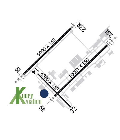

Sunrise / Sunset times for PIEDMONT TRIAD INTL

DateSunriseSunset
04/17/24 Wednesday6:4319:56
04/18/24 Thursday6:4219:57
04/19/24 Friday6:4019:58
04/20/24 Saturday6:3919:58
04/21/24 Sunday6:3819:59
04/22/24 Monday6:3720:00
04/23/24 Tuesday6:3520:01
04/24/24 Wednesday6:3420:02
04/25/24 Thursday6:3320:03
04/26/24 Friday6:3220:04
04/27/24 Saturday6:3120:04
04/28/24 Sunday6:3020:05
04/29/24 Monday6:2820:06
04/30/24 Tuesday6:2720:07

Airport Facilities

Airport Attendance ScheduleCONTINUOUS
Airport Status OPERATIONAL (This Status can change at any time - please check NOTAMS)
Airport Lighting Schedule
Airport Storage AvailableTie Downs, Hanger
Extra Services AvailableAir Freight, Avionics, Cargo Handling, Charter, Flight Instruction, Aircraft Rental, Aircraft Sales
Wind IndicatorYES - (lighted)
Control TowerYES
CTAF Frequency
Unicom Frequency122.950
Rotating Beacon ColorWG
Segmented CircleYES
Landing FeeNO

Airport Inspection Data

Airport InspectedFEDERAL - performed by FAA AIRPORTS FIELD PERSONNEL
Inspection Date06/09/2023

Airport Services

Type of Fuel AvailableGrade 100LL, JET A (freeze point -40C)
Airframe Repair ServiceMAJOR
Power Plant Repair ServiceMAJOR

Geographic Data

LatitudeN3606.1
LongitudeW07956.5 (ESTIMATED)
Arpt Elevation925ft (SURVEYED)
Magnetic Variation08W
7 miles Wof GREENSBORO
Traffic Pattern Altitude
Sectional ChartCINCINNATI

Aircraft Data

Operations (Reported)YearlyAvg. Daily
General Aviation Transient 2379765
General Aviation Local 1187933
Air Taxi 1138131
Commerical 1635145
Commuter 00
Military 25247
Aircraft based on Field
General Aviation Singles 78
General Aviation Multi 12
Jet Aircraft 17
General Aviation Helicopters 0
Military Aircraft 0
Gliders 0
Ultralights 0

FAA Services

FSS on field NO
FSS tie-in RALEIGH
FSS Phone 1-800-WX-BRIEF
Who issues Notams GSO
Notam D service at airport YES
ARTCC Name ATLANTA

Federal Status

Airport CertificationAIRPORT RECEIVING SCHEDULED AIR CARRIER SERVICE FROM CARRIERS CERTIFICATED BY THE CIVIL AERONAUTICS BOARD
Aircraft Rescue & Firefighting IndexAIRPORT HAS A CERTIFICATE UNDER CFR PART 139
Airport of EntryNo
Custom Landing RightsYES
Joint Civil/MilitaryNo
Military Landing rightsYES

Federal Agreements

NATIONAL PLAN OF INTEGRATED AIRPORT SYSTEMS (NPIAS)
GRANT AGREEMENTS UNDER FAAP/ADAP/AIP
SURPLUS PROPERTY AGREEMENT UNDER REGULATION 16-WAA
ASSURANCES PURSUANT TO TITLE VI, CIVIL RIGHTS ACT OF 1964
AGREEMENT UNDER DLAND OR DCLA HAS EXPIRED.

Remarks

ACFT WITH WINGSPAN GREATER THAN 171 FT ARE PROHIBITED FROM USING TWY E.
DUE TO NOISE SENSITIVE AREAS, ACFT PERFORMING PRACTICE APPROACHES SHALL USE RWY 05R-23L.
TWY E PORTIONS BETWEEN TWY J AND TWY H NOT VISIBLE FROM ATCT. TWY K NORTHEAST OF TWY K6 CLSD EXCEPT FOR CARGO ACFT.
FOR CD CTC GREENSBORO APCH AT 743-222-6129.
Airport Communications & Frequencies:
ATIS Frequencies:   Hours(local) of Operation: CONTINUOUS
128.55
GREENSBORO Tower Frequencies:   Hours(local) of operation: CONTINUOUS   
119.1
290.325
GREENSBORO Ground Frequencies:
121.9
348.6
Clearance Delivery Frequencies:
121.75
Emergency Frequencies:
121.5
243.0
Unicom Frequency:
122.950
GREENSBORO Primary Approach Frequencies:   Hours(local) of operation: CONTINUOUS   
124.35 ;250-049
126.6 ;050-249
269.225 ;250-049
327.075 ;050-249
GREENSBORO Primary Departure Frequencies:   Hours(local) of operation: CONTINUOUS   
124.35 ;250-049
126.6 ;050-249
269.225 ;250-049
327.075 ;050-249
Class C Frequencies:
124.35 ;250-049
126.6 ;050-249
269.225 ;250-049
327.075 ;050-249
Runway Identifications
Runway Identification: 05L/23R
Length: 9000 ft
Width: 150 ft
Surface: ASPHALT-FAIR CONDITION
Edge lights: High Intensity

Treatment: GROOVED
Weight: PCN 137/F/C/X/T

 Runway: 05L   Runway: 23R
Mag heading: 54°Mag heading: 234°
Rwy Slope: -.68% DownRwy Slope: .68% Up
Approach: ILS/DMEApproach: ILS/DME
Pattern: Left TrafficPattern: Left Traffic
Markings: PRECISION INSTRUMENTMarkings: PRECISION INSTRUMENT
Marking Condition: GOODMarking Condition: GOOD
Arresting Dev: Arresting Dev:
Lat & Long: N3606.0  W07957.5Lat. & Long.: N3607.0  W07956.2
Elev: 916.4 ft. MSLElev: 855.3 ft. MSL
TCH: 69 ft. AGLTCH: 72 ft. AGL
Visual Glide Path: 3.00 degreesVisual Glide Path: 3.00 degrees
Displaced Threshold: NoDisplaced Threshold: No
Touchdown Zone: YESTouchdown Zone: YES
Touchdown Elev.: 916.4 feetTouchdown Elev.: 863.6 feet
Visual Glide Slope: 4-Light PAPI on LEFT side of RunwayVisual Glide Slope: 4-Light PAPI on LEFT side of Runway
RVR Equipment: TOUCHDOWN-MIDFIELD-ROLLOUTRVR Equipment: TOUCHDOWN-MIDFIELD-ROLLOUT
RVV Equipment: NORVV Equipment: NO
Approach Lights: ALSF2 - standard 2,400 foot high intensity approach lighting system with sequenced flashers, Category II or IIIApproach Lights: MALSR - 1,400 foot medium intensity approach lighting system with runway alignment indicator lights
REIL: NOREIL: NO
Centerline Lights: YESCenterline Lights: YES
Touchdown lights: YESTouchdown lights: YES
Runway Category: Precision Instrument RunwayRunway Category: Precision Instrument Runway
Declared Distances: TORA:9000' TODA:9000' ASDA:9000' LDA:9000'Declared Distances: TORA:9000' TODA:9000' ASDA:9000' LDA:9000'
Runway Identification: 05R/23L
Length: 10001 ft
Width: 150 ft
Surface: ASPHALT-GOOD CONDITION
Edge lights: High Intensity

Treatment: GROOVED
Weight: PCN 91 /F/C/X/T

 Runway: 05R   Runway: 23L
Mag heading: 54°Mag heading: 234°
Rwy Slope: -.14% DownRwy Slope: .14% Up
Approach: ILS/DMEApproach: ILS
Pattern: Left TrafficPattern: Left Traffic
Markings: PRECISION INSTRUMENTMarkings: PRECISION INSTRUMENT
Marking Condition: GOODMarking Condition: GOOD
Arresting Dev: Arresting Dev:
Lat & Long: N3605.5  W07956.7Lat. & Long.: N3606.6  W07955.2
Elev: 899.5 ft. MSLElev: 885.8 ft. MSL
TCH: 70 ft. AGLTCH: 55 ft. AGL
Visual Glide Path: 3.00 degreesVisual Glide Path: 3.00 degrees
Displaced Threshold: NoDisplaced Threshold: No
Touchdown Zone: YESTouchdown Zone: YES
Touchdown Elev.: 900.3 feetTouchdown Elev.: 889.4 feet
Visual Glide Slope: 4-Light PAPI on RIGHT side of RunwayVisual Glide Slope: 4-Light PAPI on LEFT side of Runway
RVR Equipment: TOUCHDOWN-MIDFIELD-ROLLOUTRVR Equipment: TOUCHDOWN-MIDFIELD-ROLLOUT
RVV Equipment: NORVV Equipment: NO
Approach Lights: MALSR - 1,400 foot medium intensity approach lighting system with runway alignment indicator lightsApproach Lights: ALSF2 - standard 2,400 foot high intensity approach lighting system with sequenced flashers, Category II or III
REIL: NOREIL: NO
Centerline Lights: YESCenterline Lights: YES
Touchdown lights: NOTouchdown lights: YES
Runway Category: Precision Instrument RunwayRunway Category: Precision Instrument Runway
Declared Distances: TORA:10001' TODA:10001' ASDA:10001' LDA:10001'Declared Distances: TORA:10001' TODA:10001' ASDA:9601' LDA:9601'
Runway Identification: 14/32
Length: 6380 ft
Width: 150 ft
Surface: ASPHALT-FAIR CONDITION
Edge lights: High Intensity

Treatment: GROOVED
Weight: PCN 62 /F/C/X/T

 Runway: 14   Runway: 32
Mag heading: 143°Mag heading: 323°
Rwy Slope: -.40% DownRwy Slope: .40% Up
Approach: ILSApproach: ILS/DME
Pattern: Left TrafficPattern: Left Traffic
Markings: PRECISION INSTRUMENTMarkings: PRECISION INSTRUMENT
Marking Condition: GOODMarking Condition: GOOD
Arresting Dev: Arresting Dev:
Lat & Long: N3606.0  W07957.1Lat. & Long.: N3605.2  W07956.2
Elev: 925.4 ft. MSLElev: 900.0 ft. MSL
TCH: TCH: 53 ft. AGL
Visual Glide Path: Visual Glide Path: 3.00 degrees
Displaced Threshold: NoDisplaced Threshold: No
Touchdown Zone: YESTouchdown Zone: YES
Touchdown Elev.: 925.5 feetTouchdown Elev.: 902.1 feet
Visual Glide Slope: Visual Glide Slope: 4-Light PAPI on LEFT side of Runway
RVR Equipment: RVR Equipment:
RVV Equipment: NORVV Equipment: NO
Approach Lights: Approach Lights:
REIL: NOREIL: YES
Centerline Lights: NOCenterline Lights: NO
Touchdown lights: NOTouchdown lights: NO
Runway Category: Precision Instrument RunwayRunway Category: Precision Instrument Runway
Declared Distances: TORA:6380' TODA:6380' ASDA:6380' LDA:6380'Declared Distances: TORA:6380' TODA:6380' ASDA:6380' LDA:6380'
C:175/P: