
| ||||||||||||||||||||||||||||||||
| ||||||||||||||||||||||||||||||||
| Rwy | Rwy | |||||||
| 11760x300 | 11760' | 109.30 - 081° | 11760x300 | 11760' | 109.90 - 261° | |||
| Runway ID | Single Wheel | Double Wheel | Double Tandem Wheel | Dual Double Wheel |
| 08/26 | N/A | N/A | N/A | N/A |
| These numbers are Advisory and are not limits. The Airport Manager should have more accurate Weight Limits | ||||
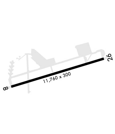 Airport Diagram might not be current. | |
| Facility Name: | SEYMOUR JOHNSON AFB |
| City Name: | GOLDSBORO |
| County: | WAYNE |
| State abbrev: | NC |
| State Name: | NORTH CAROLINA |
| Ownership: | AIR FORCE OWNED |
| Use: | PRIVATE |
| Owner's Name: | USAF AIRFIELD OPS |
| Address: | 1105 RAPCON PL BLDG 4750 |
| SEYMOUR JOHNSON AFB, NC 27531 | |
| Owner's Phone: | 919-722-2102 |
| Manager's Name: | AIRFIELD MANAGER |
| Address: | 4OSS/OSAA 1980 JABARA AVE |
| SEYMOUR JOHNSON AFB, NC 27531 | |
| Phone: | 919-722-4097 |
| FAA Region: | SOUTHERN |
| FAA Field Office: | MEM |
| Date | Sunrise | Sunset |
|---|---|---|
| 04/24/24 Wednesday | 6:27 | 19:53 |
| 04/25/24 Thursday | 6:26 | 19:54 |
| 04/26/24 Friday | 6:25 | 19:54 |
| 04/27/24 Saturday | 6:24 | 19:55 |
| 04/28/24 Sunday | 6:23 | 19:56 |
| 04/29/24 Monday | 6:22 | 19:57 |
| 04/30/24 Tuesday | 6:21 | 19:58 |
| 05/01/24 Wednesday | 6:20 | 19:59 |
| 05/02/24 Thursday | 6:19 | 19:59 |
| 05/03/24 Friday | 6:18 | 20:00 |
| 05/04/24 Saturday | 6:17 | 20:01 |
| 05/05/24 Sunday | 6:16 | 20:02 |
| 05/06/24 Monday | 6:15 | 20:03 |
| 05/07/24 Tuesday | 6:14 | 20:03 |
| Airport Attendance Schedule | 7 Days A Week 1200-0400Z++; OPR 1200-1400Z++ OR AS PUBLD BY NOTAM. WKEND AND HOL HR MAY CHG BASED ON FLYING OPS. CTC AFLD MGMT 919-722-4097 OR DSN 722-4097 PRIOR MSN PLANNING TO CFM AD HRS. SEE FLIP AP/1 SUPPLRY ARPT |
| Airport Status | OPERATIONAL (This Status can change at any time - please check NOTAMS) |
| Airport Lighting Schedule | |
| Airport Storage Available | NONE |
| Extra Services Available | NONE |
| Wind Indicator | YES - (unlit) |
| Control Tower | YES |
| CTAF Frequency | |
| Unicom Frequency | |
| Rotating Beacon Color | WG |
| Segmented Circle | NO |
| Landing Fee |
| Airport Inspected | No Inspection Data Available performed by the OWNER |
| Inspection Date | Unknown |
| Type of Fuel Available | JET A |
| Airframe Repair Service | None |
| Power Plant Repair Service | None |
| Latitude | N3520.4 |
| Longitude | W07757.6 (ESTIMATED) |
| Arpt Elevation | 109ft (SURVEYED) |
| Magnetic Variation | 08W |
| 3 miles SE | of GOLDSBORO |
| Traffic Pattern Altitude | 1191; TPA: RECTANGULAR 1191 FT AGL/1300 FT MSL. OVHD PAT 1691 FT AGL/1800 FT MSL. LT ACFT 891 FT AGL/1000 FT MSL. |
| Sectional Chart | CHARLOTTE |
| Operations (Reported) | Yearly | Avg. Daily |
|---|---|---|
| General Aviation Transient | 0 | 0 |
| General Aviation Local | 0 | 0 |
| Air Taxi | 0 | 0 |
| Commerical | 0 | 0 |
| Commuter | 0 | 0 |
| Military | 54000 | 148 |
| Aircraft based on Field | |
|---|---|
| General Aviation Singles | 0 |
| General Aviation Multi | 0 |
| Jet Aircraft | 0 |
| General Aviation Helicopters | 0 |
| Military Aircraft | 5 |
| Gliders | 0 |
| Ultralights | 0 |
| FSS on field | NO |
| FSS tie-in | RALEIGH; FSS-RALEIGH RDU-NOTAM RDU. |
| FSS Phone | 1-800-WX-BRIEF |
| Who issues Notams | GSB |
| Notam D service at airport | YES |
| ARTCC Name | WASHINGTON |
| Airport Certification | |
| Aircraft Rescue & Firefighting Index | None |
| Airport of Entry | No |
| Custom Landing Rights | No |
| Joint Civil/Military | No |
| Military Landing rights | No |
| CAUTION: EXP HVY BLACKBIRD ACT DUR SUMMER AND FALL. |
| CSTMS/AG/IMG: LTD CSTMS AVBL, PRIOR COORD RQR. FAC FOR HANDLING CONTAMINATED AG WASTE LTD. |
| MISC: ALL INBD ACFT WITH VIP CTC CONSOLIDATED COMD POST WHEN 60 NM OUT. |
| MISC: HVY ACFT LAND LONG OVER BAK-12S, IFUN CTC AMOPS 30 MIN PRIOR. |
| CAUTION: TREES 3000 FT E OF AER 26. |
| RSTD: PPR REQUIRED FOR ALL ACFT TO INCLUDE DV, HAZ CARGO AND AIR EVAC REGARDLESS OF AFFILIATION FOR NOTIFICATION AND COORDINATION PURPOSES. |
| LGT: RWY 08-26 70 FT GATED THR LGT. |
| MISC: NON-STD MARKINGS EXIST ON THE HOT CARGO PAD FOR MOTORCYCLE SAFETY COURSE. DIMENSION OF MARKINGS ARE CONTAINED IN A 120 FT X 220 FT BOX LOCATED SOUTH OF THE TAXI LINE USING A YELLOW AND WHITE PAINT MARKING SCHEME. |
| MISC: RCR/RSC NOT REPORTED BY SEYMOUR-JOHNSON BASE WX. |
| PMSV METRO: WX DSN 722-4089/4089 C919-722-4087 FORECASTER AVBL 0300-0400Z++MON-FRI W/DEVIATIONS DETERMINED BY 916 ARW & 4 FW OPR HRS. OPR HRS MAY VARY WITH LCL FLYING SKED. REMOTE BRIEFING SVC AVBL FR 26 OWS, BARKSDALE AFB, DSN 331-2635/2636/2651, C318-529-2635/2636/2651, FAX EXT 2609, WEBSITE: HTTPS://26OWS.US.AF.MIL. WX OBSN AVBL 24 HRS VIA AN/FMQ-19 AUTOMATED OBSN SYS AUGMENTED BY HUMAN OBSN DUR HR. |
| A-GEAR: BAK-12B(B) ALWAYS IN PLACE. THE POTENTIAL FOR TAIL HOOK SLIP EXIST, DUE CONC INLAY MEETING ASPHALT PAVEMENT AT THE RWY 26 UNDERRUN/RWY 08 OVRN BAK 12 BARRIER. |
| CAUTION: C5 ACFT SHOULD EXP REDUCED LEVEL OF SVC. |
| RSTD: ISSUED PPR VALID 30 MINS PRIOR OR AFTER ETA, EARLY/LATE ARR/DEP MUST BE RECOORDINATED. |
| NOISE ABATEMENT - QUIET HRS 0330-1100Z++ FOR FURTHER INFO CALL BASE OPS AT C919-722-4097. |
| TWY F NO ACFT LARGER THAN C-130. |
| MISC: UHF EQUIPPED ACFT WILL USE UHF AS PRIM ATC FREQ WHEN ARR/DEP SEYMOUR JOHNSON. |
| MISC: COMSEC STORAGE AT COMD POST. |
| CAUTION: POTENTIAL FOR SMALL UAS ACT OUTSIDE OF AFLD OPR HR. |
| MISC: APRON FLOOD LIGHTS LOCATED 1402 FT FM RWY CNTRLN AT THE SOUTHERN CORNERS OF THE TANKER RAMP. ONE IS LOCATED AT THE SW CORNER AT THE HEIGHT OF 102 FT AMSL AND THE OTHER ONE IS LOCATED AT THE SE CORNER AT THE HEIGHT OF 101 FT AMSL. |
| JASU: 8(M32A-60A/B) 5(M32A-86) 1(MC-11) 1(MC-1A). |
| FLUID: SP PRESAIR LPOX LOX - 24 HR PPR. |
| OIL: O-148 SOAP. |
| TRAN ALERT: AVBL 1200-0400Z++ MON-FRI, 1530-2300Z++ SAT-SUN STANDBY ALL OTHER TIMES. EXP 1-2 HR SVC/REFUEL DELAYS WKEND, HOL, PEAK PERIODS AND LTD MAINT. LTD FLEET SVC AVBL FOR MIL ACFT ONLY. 50 GAL LAVATORY CART WILL BE SUPPLIED TO AIRCREW TO SVC ACFT. |
| RSTD: TRAN ACFT EXP FULL STOP LDG DUR LCL FLYING PERIOD. CTC AMOPS 7 DAYS PRIOR FOR PPR, PN DSN 722-4097, C919-722-4097. TWY A CLOSED TO C5 ACFT EAST OF TWY G. TWY F AVBL FOR ACFT WITH WINGSPANS OF 44 FT OR LESS. COORD WITH AIRFIELD MGR FOR LARGER ACFT. |
| RWY 08/2 6 MISC RWY 08/26, FROM AER 26 FIRST 1000X300 FT CONC. 1000 FT TO 3100 FT IS 150 FT WIDE CONC WITH 75 FT ASPH EACH SIDE; 3100 FT TO 10760 FT IS 75 FT WIDE CONC AND 112.5 FT ASPH EACH SIDE; FR 10760 FT TO 11760 FT ARE 300 FT WIDE CONC. NO SHOULDERS ON RWY. RWY LGTS ALONG USBL PAV. |
Airport Communications & Frequencies:
| |||||||||||||||||||||||||||||||||||||||||||||
| Runway: 08 | Runway: 26 | ||
| Mag heading: | 81° | Mag heading: | 261° |
| Rwy Slope: | .31% Up | Rwy Slope: | -.31% Down |
| Approach: | ILS | Approach: | LOC/GS |
| Pattern: | Right Traffic | Pattern: | Right Traffic; LARGE AIRCRAFT. |
| Markings: | PRECISION INSTRUMENT | Markings: | PRECISION INSTRUMENT |
| Marking Condition: | GOOD | Marking Condition: | GOOD |
| Arresting Dev: | BAK-12; HOOK BAK-12A(B) (36 FT OVRN) HOOK BAK-12B(B) (1490 FT). | Arresting Dev: | BAK-12; HOOK BAK-12B(B) (1490 FT) HOOK BAK-12A(B) (52 FT OVRN). |
| Lat & Long: | N3520.1 W07758.8 | Lat. & Long.: | N3520.6 W07756.5 |
| Elev: | 72.4 ft. MSL | Elev: | 109.0 ft. MSL |
| TCH: | 55 ft. AGL | TCH: | 56 ft. AGL |
| Visual Glide Path: | 3.00 degrees | Visual Glide Path: | 3.00 degrees |
| Displaced Threshold: | No | Displaced Threshold: | No |
| Touchdown Zone: | YES | Touchdown Zone: | YES |
| Touchdown Elev.: | 73.0 feet | Touchdown Elev.: | 109.0 feet |
| Visual Glide Slope: | 4-Light PAPI on LEFT side of Runway | Visual Glide Slope: | 4-Light PAPI on LEFT side of Runway |
| RVR Equipment: | TOUCHDOWN | RVR Equipment: | TOUCHDOWN |
| RVV Equipment: | NO | RVV Equipment: | NO |
| Approach Lights: | ALSF1 - standard 2,400 foot high intensity approach lighting system with sequenced flashers, Category I | Approach Lights: | ALSF1 - standard 2,400 foot high intensity approach lighting system with sequenced flashers, Category I |
| REIL: | NO | REIL: | NO |
| Centerline Lights: | NO | Centerline Lights: | NO |
| Touchdown lights: | NO | Touchdown lights: | NO |
| Runway Category: | Runway Category: | ||
| Declared Distances: | TORA:11760' TODA:11760' ASDA:11760' | Declared Distances: | TORA:11760' TODA:11760' ASDA:11760' |
