Current Weather/Notams (Metars, TAFs, Notams, NWS Forecast, PIREPS, and nearby weather)
Customs Information Send updates to Support@FltPlan.com
Customs Not Available
Database effective 05/16/2024
Airport Diagram might not be current.
|
| Facility Name: | GORDON MUNI |
| City Name: | GORDON |
| County: | SHERIDAN |
| State abbrev: | NE |
| State Name: | NEBRASKA |
| | |
| Ownership: | PUBLICLY OWNED |
| Use: | OPEN TO THE PUBLIC |
| Owner's Name: | GORDON ARPT AUTH; MARK KRUGER (605) 840-0177. |
| Address: | PO BOX 310 |
| | GORDON, NE 69343-0310 |
| Owner's Phone: | 308-282-0837 |
| | |
| Manager's Name: | GLEN SPAUGH |
| Address: | PO BOX 310 |
| | GORDON, NE 69343-0310 |
| Phone: | 308-282-0837 |
| | |
| FAA Region: | CENTRAL |
| FAA Field Office: | NONE |
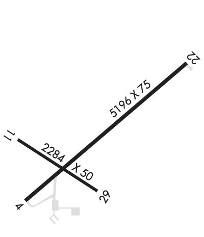
Runway Identifications
Runway Identification: 04/22Length: 5196 ft
Width: 75 ft
Surface: ASPHALT-GOOD CONDITION
Edge lights: Medium IntensityTreatment: NONE
| | Runway: 04 | | Runway: 22 |
| Mag heading: | 40° | Mag heading: | 220° |
| Rwy Slope: | .36% Up | Rwy Slope: | -.36% Down |
| Approach: | | Approach: | |
| Pattern: | Left Traffic | Pattern: | Left Traffic |
| Markings: | NONPRECISION INSTRUMENT | Markings: | NONPRECISION INSTRUMENT |
| Marking Condition: | GOOD | Marking Condition: | GOOD |
| Arresting Dev: | | Arresting Dev: | |
| Lat & Long: | N4248.1 W10210.9 | Lat. & Long.: | N4248.7 W10210.0 |
| Elev: | 3543.5 ft. MSL | Elev: | 3562.1 ft. MSL |
| TCH: | 39 ft. AGL | TCH: | 39 ft. AGL |
| Visual Glide Path: | 3.00 degrees | Visual Glide Path: | 3.00 degrees |
| Displaced Threshold: | No | Displaced Threshold: | No |
| Touchdown Zone: | YES | Touchdown Zone: | YES |
| Touchdown Elev.: | 3545.3 feet | Touchdown Elev.: | 3562.1 feet |
| Visual Glide Slope: | 2-Light PAPI on LEFT side of Runway | Visual Glide Slope: | 2-Light PAPI on LEFT side of Runway |
| RVR Equipment: | | RVR Equipment: | |
| RVV Equipment: | NO | RVV Equipment: | NO |
| Approach Lights: | | Approach Lights: | |
| REIL: | NO | REIL: | NO |
| Centerline Lights: | NO | Centerline Lights: | NO |
| Touchdown lights: | NO | Touchdown lights: | NO |
| Runway Category: | Runway with a Non-precision Approach | Runway Category: | Runway with a Non-precision Approach |
| Declared Distances: | | Declared Distances: | |
| Obstructions: | TREES | Obstructions: | ROAD |
| Marked: | NOT Marked/Lighted | Marked: | NOT Marked/Lighted |
| Clearance slope: | 17:1 | Clearance slope: | 22:1 |
| Obstruction height: | 57 feet AGL | Obstruction height: | 21 feet AGL |
| Dist. from runway: | 1213 feet | Dist. from runway: | 673 feet |
| Centerline offset: | 197 right of centerline | Centerline offset: | |
| Comments: | | Comments: | |
Runway Identification: 11/29Length: 2284 ft
Width: 50 ft
Surface: ASPHALT-POOR CONDITION
Edge lights: Medium IntensityTreatment: NONE
| | Runway: 11 | | Runway: 29 |
| Mag heading: | 114° | Mag heading: | 294° |
| Rwy Slope: | -.30% Down | Rwy Slope: | .30% Up |
| Approach: | | Approach: | |
| Pattern: | Left Traffic | Pattern: | Left Traffic |
| Markings: | BASIC | Markings: | BASIC |
| Marking Condition: | FAIR | Marking Condition: | FAIR |
| Arresting Dev: | | Arresting Dev: | |
| Lat & Long: | N4248.4 W10210.9 | Lat. & Long.: | N4248.2 W10210.5 |
| Elev: | 3548.9 ft. MSL | Elev: | 3542.1 ft. MSL |
| TCH: | | TCH: | |
| Visual Glide Path: | | Visual Glide Path: | |
| Displaced Threshold: | No | Displaced Threshold: | No |
| Touchdown Zone: | YES | Touchdown Zone: | YES |
| Touchdown Elev.: | 3548.9 feet | Touchdown Elev.: | 3548.9 feet |
| Visual Glide Slope: | | Visual Glide Slope: | |
| RVR Equipment: | | RVR Equipment: | |
| RVV Equipment: | NO | RVV Equipment: | NO |
| Approach Lights: | | Approach Lights: | |
| REIL: | NO | REIL: | NO |
| Centerline Lights: | NO | Centerline Lights: | NO |
| Touchdown lights: | NO | Touchdown lights: | NO |
| Runway Category: | Runway with a Visual Approach | Runway Category: | Runway with a Visual Approach |
| Declared Distances: | | Declared Distances: | |
| Obstructions: | ROAD | Obstructions: | FENCE |
| Marked: | NOT Marked/Lighted | Marked: | NOT Marked/Lighted |
| Clearance slope: | 15:1 | Clearance slope: | 7:1 |
| Obstruction height: | 15 feet AGL | Obstruction height: | 3 feet AGL |
| Dist. from runway: | 433 feet | Dist. from runway: | 222 feet |
| Centerline offset: | | Centerline offset: | 127 feet right of centerline |
| Comments: | | Comments: | |

