Click here for more info on on SMS!

KGRD

GREENWOOD COUNTY
GREENWOOD
SC
Time Zone: Eastern
Lat: N 3415.0
Long: W 08209.5
Elev: 631
Var: +07
Longest Runway: 5001
AWOS: 121.12
CTAF: 122.97

FBO & Flight Services info for KGRD

FBOs: Update your Fuel Prices

AERO SERVICESPh: 864-942-9634 Fax: 864-943-1518 Freq: 22.97
Service
Jet
100LL
SAF
MoGas
Fuel Avail: M-F 7:30-6 Sat 8-5 Sun 11-5 after hours fee
Full5.895.99    Last Update: 03/22/2024 07:56

Self        
 Address: 322 TERMINAL RD.,   GREENWOOD, SC 29649
AWOSPh: 864-388-9115
-
Freq: 121.12  
If you are an FBO, call 1-203-262-1700 to update your info or email: FltPlan.Advertising@garmin.com
Advertise your FBO on FltPlan.com

Runway & Approach Info for KGRD
Rwy
Length
Land Dist**
Approach*
  Rwy
Length
Land Dist**
Approach*
05
3600x60  3600'          
 
  
23
  3600x60  3600'          
 
09
5001x100  5001'          
 
  
27
  5001x100  5001'          
 
 * only ILS, LOC, LDA, and SDF approaches to a specific runway are shown
** For any Declared Landing Distance Available, please see A/FD or Approach plates
Runway Weight Capability (lbs.) Help
Runway IDSingle WheelDouble WheelDouble Tandem WheelDual Double Wheel
05/23N/AN/AN/AN/A
09/2789,000122,000N/AN/A
These numbers are Advisory and are not limits.   The Airport Manager should have more accurate Weight Limits
Approach Charts
Approaches    
Current Weather/Notams
Customs Information Send updates to Support@FltPlan.com
Customs Not Available
Database effective 04/18/2024
Airport Diagram of KGRD
Airport Diagram might not be current.

Facility Name: GREENWOOD COUNTY
City Name: GREENWOOD
County: GREENWOOD
State abbrev: SC
State Name: SOUTH CAROLINA
   
Ownership: PUBLICLY OWNED
Use: OPEN TO THE PUBLIC
Owner's Name: GREENWOOD COUNTY
Address: 600 MONUMENT STREET
 GREENWOOD, SC 29646
Owner's Phone: 864-942-8502
  
Manager's Name: RETT TEMPLETON; FBO PHONE 864-942-9634
Address: 528 MONUMENT STREET, ROOM B-03
 GREENWOOD, SC 29649
Phone: (864) 942-8556
   
FAA Region: SOUTHERN
FAA Field Office: ATL


Sunrise / Sunset times for GREENWOOD COUNTY

DateSunriseSunset
04/19/24 Friday6:5220:04
04/20/24 Saturday6:5020:05
04/21/24 Sunday6:4920:06
04/22/24 Monday6:4820:06
04/23/24 Tuesday6:4720:07
04/24/24 Wednesday6:4620:08
04/25/24 Thursday6:4520:09
04/26/24 Friday6:4420:10
04/27/24 Saturday6:4220:10
04/28/24 Sunday6:4120:11
04/29/24 Monday6:4020:12
04/30/24 Tuesday6:3920:13
05/01/24 Wednesday6:3820:13
05/02/24 Thursday6:3720:14

Airport Facilities

Airport Attendance ScheduleSAT 0800-1700, MON-FRI 0730-1800, SUN 1100-1700
Airport Status OPERATIONAL (This Status can change at any time - please check NOTAMS)
Airport Lighting Schedule
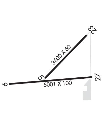
MIRL RY 09/27 PRESET ON MED INTST DUSK-2300; TO INCR INTST & ACTVT REIL RYS 09 & 27 - CTAF. AFTER 2300, ACTVT MIRL RY 09/27, REIL RYS 09 & 27 AND ODALS RY 27 - CTAF.
Airport Storage AvailableTie Downs
Extra Services AvailableCharter, Flight Instruction, Aircraft Rental
Wind IndicatorYES - (lighted)
Control TowerNO
CTAF Frequency122.975
Unicom Frequency122.975
Rotating Beacon ColorWG
Segmented CircleYES
Landing FeeNO

Airport Inspection Data

Airport InspectedSTATE - performed by STATE AERONAUTICAL PERSONNEL
Inspection Date06/16/2022

Airport Services

Type of Fuel AvailableGrade 100LL, JET A (freeze point -40C)
Airframe Repair ServiceMAJOR
Power Plant Repair ServiceMINOR

Geographic Data

LatitudeN3415.0
LongitudeW08209.5 (ESTIMATED)
Arpt Elevation631ft (SURVEYED)
Magnetic Variation07W
3 miles Nof GREENWOOD
Traffic Pattern Altitude
Sectional ChartATLANTA

Aircraft Data

Operations (Reported)YearlyAvg. Daily
General Aviation Transient 450012
General Aviation Local 675018
Air Taxi 7502
Commerical 00
Commuter 00
Military 1000
Aircraft based on Field
General Aviation Singles 46
General Aviation Multi 7
Jet Aircraft 0
General Aviation Helicopters 0
Military Aircraft 0
Gliders 0
Ultralights 0

FAA Services

FSS on field NO
FSS tie-in ANDERSON
FSS Phone 1-800-WX-BRIEF
Who issues Notams GRD
Notam D service at airport YES
ARTCC Name ATLANTA

Federal Status

Airport Certification
Aircraft Rescue & Firefighting IndexNone
Airport of EntryNo
Custom Landing RightsNo
Joint Civil/MilitaryNo
Military Landing rightsYES

Federal Agreements

NATIONAL PLAN OF INTEGRATED AIRPORT SYSTEMS (NPIAS)
GRANT AGREEMENTS UNDER FAAP/ADAP/AIP
SURPLUS PROPERTY AGREEMENT UNDER PUBLIC LAW 289
SURPLUS PROPERTY AGREEMENT UNDER REGULATION 16-WAA
ASSURANCES PURSUANT TO TITLE VI, CIVIL RIGHTS ACT OF 1964

Remarks

TWY A PARALLEL TO RY 09/27; DROPOFFS EACH SIDE OF TWY BEYOND SHOULDER.
FOR CD IF UNA TO CTC ON FSS FREQ, CTC GREER APCH AT 864-877-8275, WHEN APCH CLSD CTC ATLANTA ARTCC AT 770-210-7692.
Airport Communications & Frequencies:
CTAF Frequency:
122.975
Unicom Frequency:
122.975
Remarks
  • APCH/DEP SVC PRVDD BY ATLANTA ARTCC ON FREQS 135.35/263.125 (OWING RCAG) WHEN APCH CTL CLSD.
  • GREER Primary Approach Frequencies:  
    120.6
    350.2
    GREER Primary Departure Frequencies:  
    120.6
    350.2
    Runway Identifications
    Runway Identification: 05/23
    Length: 3600 ft
    Width: 60 ft
    Surface: ASPHALT-FAIR CONDITION
    Edge lights:

    Treatment: AGGREGATE FRICTION SEAL COAT

     Runway: 05   Runway: 23
    Mag heading: 51°Mag heading: 231°
    Rwy Slope: -.27% DownRwy Slope: .27% Up
    Approach: Approach:
    Pattern: Left TrafficPattern: Left Traffic
    Markings: BASICMarkings: BASIC
    Marking Condition: GOODMarking Condition: GOOD
    Arresting Dev: Arresting Dev:
    Lat & Long: N3414.9  W08209.6Lat. & Long.: N3415.4  W08209.1
    Elev: 627.6 ft. MSLElev: 617.7 ft. MSL
    TCH: TCH:
    Visual Glide Path: Visual Glide Path:
    Displaced Threshold: NoDisplaced Threshold: No
    Touchdown Zone: YESTouchdown Zone: YES
    Touchdown Elev.: 628.0 feetTouchdown Elev.: 626.0 feet
    Visual Glide Slope: Visual Glide Slope:
    RVR Equipment: RVR Equipment:
    RVV Equipment: NORVV Equipment: NO
    Approach Lights: Approach Lights:
    REIL: NOREIL: NO
    Centerline Lights: NOCenterline Lights: NO
    Touchdown lights: NOTouchdown lights: NO
    Runway Category: Runway with a Visual ApproachRunway Category: Runway with a Visual Approach
    Declared Distances: Declared Distances:
    Obstructions: TREEObstructions: TREE
    Marked: NOT Marked/LightedMarked: NOT Marked/Lighted
    Clearance slope: 33:1Clearance slope: 18:1
    Obstruction height: 50 feet AGLObstruction height: 67 feet AGL
    Dist. from runway: 1865 feetDist. from runway: 1472 feet
    Centerline offset: 248 left of centerlineCenterline offset: 119 feet right of centerline
    Comments: Comments:
    Runway Identification: 09/27
    Length: 5001 ft
    Width: 100 ft
    Surface: CONCRETE
    Edge lights: Medium Intensity

    Treatment: NONE
    Weight: PCN 35 /F/C/X/T

     Runway: 09   Runway: 27
    Mag heading: 92°Mag heading: 272°
    Rwy Slope: -.17% DownRwy Slope: .17% Up
    Approach: Approach:
    Pattern: Left TrafficPattern: Left Traffic
    Markings: NONPRECISION INSTRUMENTMarkings: NONPRECISION INSTRUMENT
    Marking Condition: GOODMarking Condition: GOOD
    Arresting Dev: Arresting Dev:
    Lat & Long: N3414.9  W08210.0Lat. & Long.: N3415.0  W08209.0
    Elev: 628.8 ft. MSLElev: 620.3 ft. MSL
    TCH: 55 ft. AGLTCH: 53 ft. AGL
    Visual Glide Path: 3.00 degreesVisual Glide Path: 3.00 degrees
    Displaced Threshold: NoDisplaced Threshold: No
    Touchdown Zone: YESTouchdown Zone: YES
    Touchdown Elev.: 631.2 feetTouchdown Elev.: 629.3 feet
    Visual Glide Slope: 2-Light PAPI on LEFT side of RunwayVisual Glide Slope: 2-Light PAPI on LEFT side of Runway
    RVR Equipment: RVR Equipment:
    RVV Equipment: NORVV Equipment: NO
    Approach Lights: Approach Lights: ODALS - omnidirectional approach lighting system
    REIL: YESREIL: YES
    Centerline Lights: NOCenterline Lights: NO
    Touchdown lights: NOTouchdown lights: NO
    Runway Category: Runway with a Non-precision Approach having visibility minimums greater than 3/4 mileRunway Category: Runway with a Non-precision Approach having visibility minimums greater than 3/4 mile
    Declared Distances: Declared Distances:
    Obstructions: TREEObstructions:
    Marked: NOT Marked/LightedMarked:
    Clearance slope: 22:1Clearance slope: 34:1
    Obstruction height: 45 feet AGLObstruction height:
    Dist. from runway: 1223 feetDist. from runway:
    Centerline offset: 32 right of centerlineCenterline offset:
    Comments: Comments:
    C:8/P: