Current Weather/Notams (Metars, TAFs, Notams, NWS Forecast, PIREPS, and nearby weather)
Customs Information Send updates to Support@FltPlan.com
Customs Not Available
Database effective 05/16/2024
Airport Diagram might not be current.
|
| Facility Name: | GRAYLING AAF |
| City Name: | GRAYLING |
| County: | CRAWFORD |
| State abbrev: | MI |
| State Name: | MICHIGAN |
| | |
| Ownership: | ARMY OWNED |
| Use: | OPEN TO THE PUBLIC |
| Owner's Name: | US ARMY |
| Address: | MI DEPT OF MILITARY & VETERANS AFF, 3411 N MLK BLVD |
| | LANSING, MI 48906-2934 |
| Owner's Phone: | 517-483-5645 |
| | |
| Manager's Name: | SCOTT KARNER |
| Address: | JMTC GAAF BLDG 1160, CAMP GRAYLING |
| | GRAYLING, MI 49738 |
| Phone: | 989-344-4301; C989-344-4301 (FLT OPS) OR C517-897-8266 (FLT OPS SUPVR CELL); C989-344-4310 (AMGR CELL). |
| | |
| FAA Region: | GREAT LAKES |
| FAA Field Office: | DET |
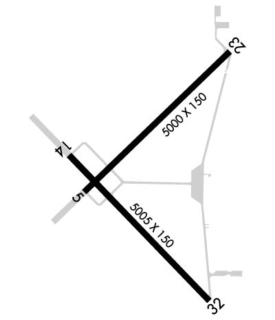
Runway Identifications
Runway Identification: 05/23Length: 5000 ft
Width: 150 ft
Surface: CONCRETE-FAIR CONDITION
Edge lights: Medium IntensityTreatment: NONE
Weight: PCN 26 /R/C/W/T
| | Runway: 05 | | Runway: 23 |
| Mag heading: | 52° | Mag heading: | 232° |
| Rwy Slope: | .13% Up | Rwy Slope: | -.13% Down |
| Approach: | | Approach: | |
| Pattern: | Left Traffic | Pattern: | Right Traffic |
| Markings: | NONPRECISION INSTRUMENT | Markings: | NONPRECISION INSTRUMENT |
| Marking Condition: | FAIR | Marking Condition: | FAIR |
| Arresting Dev: | | Arresting Dev: | |
| Lat & Long: | N4440.8 W08444.1 | Lat. & Long.: | N4441.3 W08443.3 |
| Elev: | 1151.4 ft. MSL | Elev: | 1158.0 ft. MSL |
| TCH: | 41 ft. AGL | TCH: | 30 ft. AGL |
| Visual Glide Path: | 4.00 degrees | Visual Glide Path: | 3.00 degrees |
| Displaced Threshold: | No | Displaced Threshold: | No |
| Touchdown Zone: | YES | Touchdown Zone: | YES |
| Touchdown Elev.: | 1156.4 feet | Touchdown Elev.: | 1158.1 feet |
| Visual Glide Slope: | 4-Light PAPI on LEFT side of Runway | Visual Glide Slope: | 4-Light PAPI on LEFT side of Runway |
| RVR Equipment: | | RVR Equipment: | |
| RVV Equipment: | NO | RVV Equipment: | NO |
| Approach Lights: | | Approach Lights: | |
| REIL: | YES | REIL: | YES |
| Centerline Lights: | NO | Centerline Lights: | NO |
| Touchdown lights: | NO | Touchdown lights: | NO |
| Runway Category: | Runway with a Visual Approach | Runway Category: | Runway with a Visual Approach |
| Declared Distances: | | Declared Distances: | |
| Obstructions: | TREES | Obstructions: | TREES |
| Marked: | NOT Marked/Lighted | Marked: | NOT Marked/Lighted |
| Clearance slope: | 15:1 | Clearance slope: | 18:1 |
| Obstruction height: | 75 feet AGL | Obstruction height: | 58 feet AGL |
| Dist. from runway: | 1362 feet | Dist. from runway: | 1277 feet |
| Centerline offset: | 25 right of centerline | Centerline offset: | 125 feet left of centerline |
| Comments: | | Comments: | |
Runway Identification: 14/32Length: 5005 ft
Width: 150 ft
Surface: ASPHALT-GOOD CONDITION
Edge lights: Medium IntensityTreatment: NONE
Weight: PCN 77 /F/B/W/T
| | Runway: 14 | | Runway: 32 |
| Mag heading: | 142° | Mag heading: | 322° |
| Rwy Slope: | -.08% Down | Rwy Slope: | .08% Up |
| Approach: | | Approach: | |
| Pattern: | Right Traffic | Pattern: | Left Traffic |
| Markings: | NONPRECISION INSTRUMENT | Markings: | NONPRECISION INSTRUMENT |
| Marking Condition: | FAIR | Marking Condition: | FAIR |
| Arresting Dev: | | Arresting Dev: | |
| Lat & Long: | N4440.9 W08444.2 | Lat. & Long.: | N4440.3 W08443.4 |
| Elev: | 1152.9 ft. MSL | Elev: | 1149.1 ft. MSL |
| TCH: | 29 ft. AGL | TCH: | 33 ft. AGL |
| Visual Glide Path: | 3.00 degrees | Visual Glide Path: | 3.50 degrees |
| Displaced Threshold: | No | Displaced Threshold: | 293 feet |
| Touchdown Zone: | YES | Touchdown Zone: | YES |
| Touchdown Elev.: | 1153.8 feet | Touchdown Elev.: | 1153.8 feet |
| Visual Glide Slope: | 4-Light PAPI on LEFT side of Runway; PAPI UNUSBL BYD 8 DEGS LEFT OF CNTRLN. | Visual Glide Slope: | 4-Light PAPI on LEFT side of Runway |
| RVR Equipment: | | RVR Equipment: | |
| RVV Equipment: | NO | RVV Equipment: | NO |
| Approach Lights: | | Approach Lights: | |
| REIL: | YES | REIL: | YES |
| Centerline Lights: | NO | Centerline Lights: | NO |
| Touchdown lights: | NO | Touchdown lights: | NO |
| Runway Category: | Runway with a Non-precision Approach having visibility minimums greater than 3/4 mile | Runway Category: | Runway with a Visual Approach |
| Declared Distances: | | Declared Distances: | |
| Obstructions: | TREE | Obstructions: | TREES; +26 FT PLINE, 488 FT DIST, 11:1; +15 FT ROAD, 250 FT DIST, 250 FT L, 3:1. |
| Marked: | NOT Marked/Lighted | Marked: | NOT Marked/Lighted |
| Clearance slope: | 20:1 | Clearance slope: | 12:1; APCH RATIO 20:1 TO DTHR OVR 68 FT TREES, 1423 FT DIST, 125 FT R. |
| Obstruction height: | 60 feet AGL | Obstruction height: | 61 feet AGL |
| Dist. from runway: | 1438 feet | Dist. from runway: | 939 feet |
| Centerline offset: | 435 right of centerline | Centerline offset: | 200 feet right of centerline |
| Comments: | | Comments: | |

