Current Weather/Notams (Metars, TAFs, Notams, NWS Forecast, PIREPS, and nearby weather)
Customs Information Send updates to Support@FltPlan.com
Customs Not Available
Database effective 05/16/2024
Airport Diagram might not be current.
|
| Facility Name: | GUTHRIE/EDMOND RGNL |
| City Name: | GUTHRIE |
| County: | LOGAN |
| State abbrev: | OK |
| State Name: | OKLAHOMA |
| | |
| Ownership: | PUBLICLY OWNED |
| Use: | OPEN TO THE PUBLIC |
| Owner's Name: | CITY OF GUTHRIE |
| Address: | PO BOX 908, 101 N. SECOND ST. |
| | GUTHRIE, OK 73044 |
| Owner's Phone: | 405-282-0488 |
| | |
| Manager's Name: | CADEN YOUNG |
| Address: | 520 AIRPORT RD |
| | GUTHRIE, OK 73044 |
| Phone: | 405-282-2312 |
| | |
| FAA Region: | SOUTHWEST |
| FAA Field Office: | AOK |
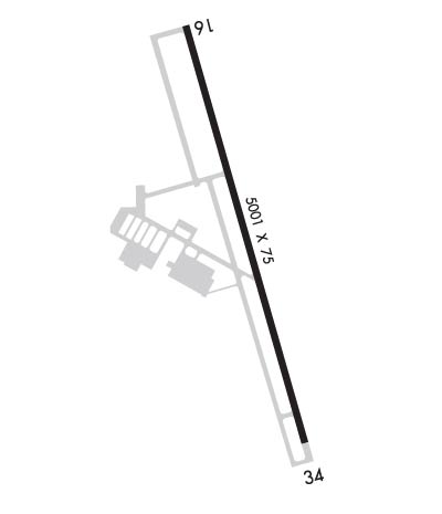
Runway Identifications
Runway Identification: 16/34Length: 5001 ft
Width: 75 ft
Surface: CONCRETE-GOOD CONDITION
Edge lights: Medium IntensityTreatment: NONE
| | Runway: 16 | | Runway: 34 |
| Mag heading: | 158° | Mag heading: | 338° |
| Rwy Slope: | .33% Up | Rwy Slope: | -.33% Down |
| Approach: | | Approach: | |
| Pattern: | Left Traffic | Pattern: | Left Traffic |
| Markings: | NONPRECISION INSTRUMENT | Markings: | NONPRECISION INSTRUMENT |
| Marking Condition: | GOOD | Marking Condition: | GOOD |
| Arresting Dev: | | Arresting Dev: | |
| Lat & Long: | N3551.5 W09725.1 | Lat. & Long.: | N3550.7 W09724.8 |
| Elev: | 1049.6 ft. MSL | Elev: | 1066.0 ft. MSL |
| TCH: | 45 ft. AGL | TCH: | 45 ft. AGL |
| Visual Glide Path: | 3.00 degrees | Visual Glide Path: | 3.00 degrees |
| Displaced Threshold: | No | Displaced Threshold: | No |
| Touchdown Zone: | YES | Touchdown Zone: | YES |
| Touchdown Elev.: | 1069.2 feet | Touchdown Elev.: | 1069.2 feet |
| Visual Glide Slope: | 4-Light PAPI on LEFT side of Runway | Visual Glide Slope: | 4-Light PAPI on LEFT side of Runway |
| RVR Equipment: | | RVR Equipment: | |
| RVV Equipment: | NO | RVV Equipment: | NO |
| Approach Lights: | ODALS - omnidirectional approach lighting system | Approach Lights: | |
| REIL: | YES | REIL: | YES |
| Centerline Lights: | NO | Centerline Lights: | NO |
| Touchdown lights: | NO | Touchdown lights: | NO |
| Runway Category: | Runway with a Non-precision Approach having visibility minimums greater than 3/4 mile | Runway Category: | Runway with a Non-precision Approach having visibility minimums greater than 3/4 mile |
| Declared Distances: | | Declared Distances: | |
| Obstructions: | | Obstructions: | TREES |
| Marked: | | Marked: | NOT Marked/Lighted |
| Clearance slope: | 34:1 | Clearance slope: | 12:1 |
| Obstruction height: | | Obstruction height: | 23 feet AGL |
| Dist. from runway: | | Dist. from runway: | 489 feet |
| Centerline offset: | | Centerline offset: | 218 feet left of centerline |
| Comments: | | Comments: | |

