Click here for more info on on SMS!

KGLW

GLASGOW MUNI
GLASGOW
KY
Time Zone: Central
Lat: N 3701.9
Long: W 08557.2
Elev: 716
Var: +04
Longest Runway: 5302
AWOS: 118.52
CTAF: 122.8

FBO & Flight Services info for KGLW

FBOs: Update your Fuel Prices

GLASGOW AVIATIONPh: 270-678-4469 Fax: 270-678-7855 Freq: 122.8
Service
Jet
100LL
SAF
MoGas
Fuel Avail: Self Service is available 24/7
Full5.646.60    Last Update: 04/09/2024 10:06

Self5.546.50    
 Address: 390 AIRPORT RD   GLASGOW, KY 42141
AWOSPh: 270-678-5787
-
Freq: 118.52  
If you are an FBO, call 1-203-262-1700 to update your info or email: FltPlan.Advertising@garmin.com
Advertise your FBO on FltPlan.com

Runway & Approach Info for KGLW
Rwy
Length
Land Dist**
Approach*
  Rwy
Length
Land Dist**
Approach*
08
5302x100  5302'          
SDF
 108.50 - 073°  
  
26
  5302x100  5001'          
 
 * only ILS, LOC, LDA, and SDF approaches to a specific runway are shown
** For any Declared Landing Distance Available, please see A/FD or Approach plates
Runway Weight Capability (lbs.) Help
Runway IDSingle WheelDouble WheelDouble Tandem WheelDual Double Wheel
08/2643,50062,000N/AN/A
These numbers are Advisory and are not limits.   The Airport Manager should have more accurate Weight Limits
Approach Charts
Approaches    
Current Weather/Notams
Customs Information Send updates to Support@FltPlan.com
Customs Not Available
Database effective 05/16/2024
Airport Diagram of KGLW
Airport Diagram might not be current.

Facility Name: GLASGOW MUNI
City Name: GLASGOW
County: BARREN
State abbrev: KY
State Name: KENTUCKY
   
Ownership: PUBLICLY OWNED
Use: OPEN TO THE PUBLIC
Owner's Name: GLASGOW AIRPORT BOARD
Address: 390 AIRPORT ROAD
 GLASGOW, KY 42141
Owner's Phone: 270-678-3272
  
Manager's Name: ED BEGLEY
Address: 390 AIRPORT RD.
 GLASGOW, KY 42141
Phone: 270-678-4469
   
FAA Region: SOUTHERN
FAA Field Office: MEM


Sunrise / Sunset times for GLASGOW MUNI

DateSunriseSunset
04/25/24 Thursday5:5619:28
04/26/24 Friday5:5419:29
04/27/24 Saturday5:5319:30
04/28/24 Sunday5:5219:31
04/29/24 Monday5:5119:32
04/30/24 Tuesday5:5019:33
05/01/24 Wednesday5:4919:34
05/02/24 Thursday5:4719:34
05/03/24 Friday5:4619:35
05/04/24 Saturday5:4519:36
05/05/24 Sunday5:4419:37
05/06/24 Monday5:4319:38
05/07/24 Tuesday5:4219:39
05/08/24 Wednesday5:4119:40

Airport Facilities

Airport Attendance ScheduleMON-SAT 0800-1700; AFT HR - 270-678-4400.
Airport Status OPERATIONAL (This Status can change at any time - please check NOTAMS)
Airport Lighting ScheduleACTVT REIL RWY 8 & 26; MIRL RWY 08/26 - CTAF.
Airport Storage AvailableTie Downs, Hanger
Extra Services AvailableAir Ambulance, Flight Instruction
Wind IndicatorYES - (lighted)
Control TowerNO
CTAF Frequency122.800
Unicom Frequency122.800
Rotating Beacon ColorWG
Segmented CircleYES
Landing FeeNO

Airport Inspection Data

Airport InspectedSTATE - performed by STATE AERONAUTICAL PERSONNEL
Inspection Date04/07/2021

Airport Services

Type of Fuel AvailableGrade 100LL, JET A
Airframe Repair ServiceMINOR
Power Plant Repair ServiceMINOR

Geographic Data

LatitudeN3701.9
LongitudeW08557.2 (ESTIMATED)
Arpt Elevation716ft (SURVEYED)
Magnetic Variation04W
2 miles NWof GLASGOW
Traffic Pattern Altitude
Sectional ChartST LOUIS

Aircraft Data

Operations (Reported)YearlyAvg. Daily
General Aviation Transient 22506
General Aviation Local 400011
Air Taxi 9453
Commerical 00
Commuter 00
Military 2001
Aircraft based on Field
General Aviation Singles 19
General Aviation Multi 4
Jet Aircraft 0
General Aviation Helicopters 3
Military Aircraft 0
Gliders 0
Ultralights 0

FAA Services

FSS on field NO
FSS tie-in LOUISVILLE
FSS Phone 1-800-WX-BRIEF
Who issues Notams LOU
Notam D service at airport YES
ARTCC Name MEMPHIS

Federal Status

Airport Certification
Aircraft Rescue & Firefighting IndexNone
Airport of EntryNo
Custom Landing RightsNo
Joint Civil/MilitaryNo
Military Landing rightsYES

Federal Agreements

NATIONAL PLAN OF INTEGRATED AIRPORT SYSTEMS (NPIAS)
GRANT AGREEMENTS UNDER FAAP/ADAP/AIP
ASSURANCES PURSUANT TO TITLE VI, CIVIL RIGHTS ACT OF 1964

Remarks

TURKEY ON & INVOF ARPT.
FOR CD CTC MEMPHIS ARTCC AT 901-368-8453/8449.
Airport Communications & Frequencies:
CTAF Frequency:
122.800
Unicom Frequency:
122.800
Remarks
  • APCH/DEP SVC PRVDD BY MEMPHIS ARTCC ON FREQS 132.9/290.3 (NASHVILLE/JOELTON RCAG).
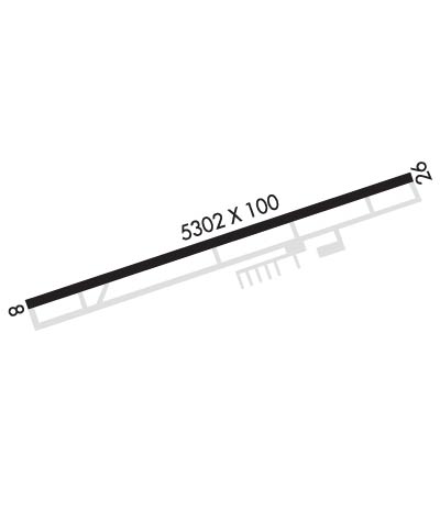
  • Runway Identifications
    Runway Identification: 08/26
    Length: 5302 ft
    Width: 100 ft
    Surface: ASPHALT-GOOD CONDITION
    Edge lights: Medium Intensity

    Treatment: NONE
    Weight: PCN 16 /F/C/X/T

     Runway: 08   Runway: 26
    Mag heading: 75°Mag heading: 255°
    Rwy Slope: .23% UpRwy Slope: -.23% Down
    Approach: SDFApproach:
    Pattern: Left TrafficPattern: Left Traffic
    Markings: NONPRECISION INSTRUMENTMarkings: NONPRECISION INSTRUMENT
    Marking Condition: GOODMarking Condition: GOOD
    Arresting Dev: Arresting Dev:
    Lat & Long: N3701.8  W08557.7Lat. & Long.: N3702.0  W08556.7
    Elev: 704.1 ft. MSLElev: 716.2 ft. MSL
    TCH: 29 ft. AGLTCH: 29 ft. AGL
    Visual Glide Path: 3.00 degreesVisual Glide Path: 3.50 degrees
    Displaced Threshold: NoDisplaced Threshold: 301 feet
    Touchdown Zone: YESTouchdown Zone: YES
    Touchdown Elev.: 709.5 feetTouchdown Elev.: 715.4 feet
    Visual Glide Slope: 2-Light PAPI on LEFT side of RunwayVisual Glide Slope: 2-Light PAPI on LEFT side of Runway
    RVR Equipment: RVR Equipment:
    RVV Equipment: NORVV Equipment: NO
    Approach Lights: Approach Lights:
    REIL: YESREIL: YES
    Centerline Lights: NOCenterline Lights: NO
    Touchdown lights: NOTouchdown lights: NO
    Runway Category: Runway with a Non-precision Approach having visibility minimums greater than 3/4 mileRunway Category: Runway with a Non-precision Approach having visibility minimums greater than 3/4 mile
    Declared Distances: TORA:5301' TODA:5301' ASDA:5000' LDA:5000'Declared Distances: TORA:5301' TODA:5301' ASDA:5301' LDA:5000'
    Obstructions: TREESObstructions: ROAD
    Marked: NOT Marked/LightedMarked: NOT Marked/Lighted
    Clearance slope: 33:1Clearance slope: 15:1; APCH RATIO 36:1 TO DSPLCD THR.
    Obstruction height: 117 feet AGLObstruction height: 24 feet AGL
    Dist. from runway: 4118 feetDist. from runway: 570 feet
    Centerline offset: 831 right of centerlineCenterline offset: B
    Comments: Comments:
    C:3/P: