Current Weather/Notams (Metars, TAFs, Notams, NWS Forecast, PIREPS, and nearby weather)
Customs Information Send updates to Support@FltPlan.com
Customs Not Available
Database effective 04/18/2024
Airport Diagram might not be current.
|
| Facility Name: | GREENVILLE MID-DELTA |
| City Name: | GREENVILLE |
| County: | WASHINGTON |
| State abbrev: | MS |
| State Name: | MISSISSIPPI |
| | |
| Ownership: | PUBLICLY OWNED |
| Use: | OPEN TO THE PUBLIC |
| Owner's Name: | CITY OF GREENVILLE |
| Address: | 340 MAIN ST |
| | GREENVILLE, MS 38701 |
| Owner's Phone: | |
| | |
| Manager's Name: | SAMUEL L WASHINGTON |
| Address: | 166 FIFTH AVE STE 300 |
| | GREENVILLE, MS 38703 |
| Phone: | 662-334-3121 |
| | |
| FAA Region: | SOUTHERN |
| FAA Field Office: | JAN |
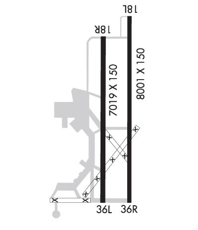
Runway Identifications
Runway Identification: 18L/36RLength: 8001 ft
Width: 150 ft
Surface: ASPHALT-FAIR CONDITION
Edge lights: High IntensityTreatment: GROOVED
Weight: PCN 61 /F/D/X/T
| | Runway: 18L | | Runway: 36R |
| Mag heading: | 181° | Mag heading: | 1° |
| Rwy Slope: | .00% Up | Rwy Slope: | .00% Down |
| Approach: | ILS | Approach: | |
| Pattern: | Left Traffic | Pattern: | Right Traffic |
| Markings: | PRECISION INSTRUMENT | Markings: | PRECISION INSTRUMENT |
| Marking Condition: | FAIR | Marking Condition: | FAIR |
| Arresting Dev: | | Arresting Dev: | |
| Lat & Long: | N3329.8 W09058.9 | Lat. & Long.: | N3328.5 W09058.9 |
| Elev: | 129.2 ft. MSL | Elev: | 129.4 ft. MSL |
| TCH: | | TCH: | 60 ft. AGL |
| Visual Glide Path: | | Visual Glide Path: | 3.00 degrees |
| Displaced Threshold: | No | Displaced Threshold: | No |
| Touchdown Zone: | YES | Touchdown Zone: | YES |
| Touchdown Elev.: | 129.2 feet | Touchdown Elev.: | 129.4 feet |
| Visual Glide Slope: | | Visual Glide Slope: | 4-Light PAPI on LEFT side of Runway |
| RVR Equipment: | TOUCHDOWN | RVR Equipment: | |
| RVV Equipment: | NO | RVV Equipment: | NO |
| Approach Lights: | MALSR - 1,400 foot medium intensity approach lighting system with runway alignment indicator lights | Approach Lights: | |
| REIL: | NO | REIL: | YES |
| Centerline Lights: | NO | Centerline Lights: | NO |
| Touchdown lights: | NO | Touchdown lights: | NO |
| Runway Category: | Precision Instrument Runway | Runway Category: | Runway with a Non-precision Approach having visibility minimums greater than 3/4 mile |
| Declared Distances: | TORA:8001' TODA:8001' ASDA:7981' LDA:7981' | Declared Distances: | TORA:8001' TODA:8001' ASDA:8001' LDA:8001' |
| Obstructions: | | Obstructions: | TREE |
| Marked: | | Marked: | NOT Marked/Lighted |
| Clearance slope: | 50:1 | Clearance slope: | 41:1 |
| Obstruction height: | | Obstruction height: | 84 feet AGL |
| Dist. from runway: | | Dist. from runway: | 3691 feet |
| Centerline offset: | | Centerline offset: | 478 feet left of centerline |
| Comments: | | Comments: | |
Runway Identification: 18R/36LLength: 7019 ft
Width: 150 ft
Surface: CONCRETE ASPHALT-POOR CONDITION
Edge lights: Medium IntensityTreatment: GROOVED
Weight: PCN 11 /R/C/X/T
| | Runway: 18R | | Runway: 36L |
| Mag heading: | 181° | Mag heading: | 1° |
| Rwy Slope: | .02% Up | Rwy Slope: | -.02% Down |
| Approach: | | Approach: | |
| Pattern: | Right Traffic | Pattern: | Left Traffic |
| Markings: | NONPRECISION INSTRUMENT | Markings: | NONPRECISION INSTRUMENT |
| Marking Condition: | POOR; MARKINGS FADED. | Marking Condition: | POOR; MARKINGS FADED. |
| Arresting Dev: | | Arresting Dev: | |
| Lat & Long: | N3329.7 W09059.2 | Lat. & Long.: | N3328.5 W09059.2 |
| Elev: | 128.4 ft. MSL | Elev: | 130.0 ft. MSL |
| TCH: | 52 ft. AGL | TCH: | 52 ft. AGL |
| Visual Glide Path: | 3.00 degrees | Visual Glide Path: | 3.00 degrees |
| Displaced Threshold: | No | Displaced Threshold: | No |
| Touchdown Zone: | YES | Touchdown Zone: | YES |
| Touchdown Elev.: | 128.4 feet | Touchdown Elev.: | 130.0 feet |
| Visual Glide Slope: | 4-Light PAPI on LEFT side of Runway | Visual Glide Slope: | 4-Light PAPI on LEFT side of Runway |
| RVR Equipment: | | RVR Equipment: | |
| RVV Equipment: | NO | RVV Equipment: | NO |
| Approach Lights: | | Approach Lights: | |
| REIL: | NO | REIL: | NO |
| Centerline Lights: | NO | Centerline Lights: | NO |
| Touchdown lights: | NO | Touchdown lights: | NO |
| Runway Category: | Runway with a Non-precision Approach having visibility minimums greater than 3/4 mile | Runway Category: | Runway with a Non-precision Approach having visibility minimums greater than 3/4 mile |
| Declared Distances: | | Declared Distances: | |
| Obstructions: | | Obstructions: | TREES |
| Marked: | | Marked: | NOT Marked/Lighted |
| Clearance slope: | 50:1 | Clearance slope: | 21:1 |
| Obstruction height: | | Obstruction height: | 56 feet AGL |
| Dist. from runway: | | Dist. from runway: | 1400 feet |
| Centerline offset: | | Centerline offset: | 425 feet left of centerline |
| Comments: | | Comments: | |

