Current Weather/Notams (Metars, TAFs, Notams, NWS Forecast, PIREPS, and nearby weather)
Customs Information Send updates to Support@FltPlan.com
Customs Not Available
Database effective 04/18/2024
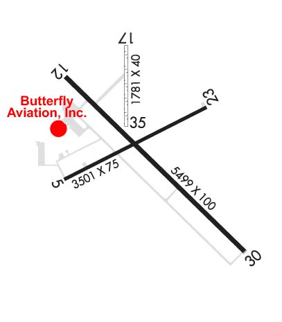
Airport Diagram might not be current. Facility Name: RENNER FLD/GOODLAND MUNI City Name: GOODLAND County: SHERMAN State abbrev: KS State Name: KANSAS Ownership: PUBLICLY OWNED Use: OPEN TO THE PUBLIC Owner's Name: CITY OF GOODLAND Address: P. O. BOX 59 GOODLAND, KS 67735 Owner's Phone: 785-890-4500 Manager's Name: ANDREW FINZEN Address: 204 W. 11TH ST. GOODLAND, KS 67735 Phone: 785-890-4500 FAA Region: CENTRAL FAA Field Office: NONE
Runway Identifications Help
Runway Identification: 05/23 Length: 4001 ftWidth: 75 ftSurface: ASPHALT-GOOD CONDITIONEdge lights: Medium Intensity Treatment: NONEWeight: PCN 5 /F/C/Y/U Runway: 05 Runway: 23 Mag heading: 54° Mag heading: 234° Rwy Slope: -.57% Down Rwy Slope: .57% Up Approach: Approach: Pattern: Left Traffic Pattern: Left Traffic Markings: NONPRECISION INSTRUMENT Markings: NONPRECISION INSTRUMENT Marking Condition: FAIR Marking Condition: FAIR Arresting Dev: Arresting Dev: Lat & Long: N3922.1 W10142.3 Lat. & Long.: N3922.4 W10141.6 Elev: 3657.6 ft. MSL Elev: 3634.7 ft. MSL TCH: 36 ft. AGL TCH: 42 ft. AGL Visual Glide Path: 3.00 degrees Visual Glide Path: 3.00 degrees Displaced Threshold: No Displaced Threshold: No Touchdown Zone: YES Touchdown Zone: YES Touchdown Elev.: 3657.6 feet Touchdown Elev.: 3651.7 feet Visual Glide Slope: 4-Light PAPI on LEFT side of Runway; PAPI UNUSBL BYD 8 DEGS L OF CNTRLN. Visual Glide Slope: 4-Light PAPI on LEFT side of Runway RVR Equipment: RVR Equipment: RVV Equipment: NO RVV Equipment: NO Approach Lights: Approach Lights: REIL: NO REIL: NO Centerline Lights: NO Centerline Lights: NO Touchdown lights: NO Touchdown lights: NO Runway Category: Runway with a Visual Approach Runway Category: Runway with a Non-precision Approach Declared Distances: Declared Distances: Obstructions: ROAD Obstructions: TREE Marked: NOT Marked/Lighted Marked: NOT Marked/Lighted Clearance slope: 1:1 Clearance slope: 12:1 Obstruction height: 15 feet AGL Obstruction height: 25 feet AGL Dist. from runway: 200 feet Dist. from runway: 505 feet Centerline offset: 282 right of centerline Centerline offset: 312 feet left of centerline Comments: Comments:
Runway Identification: 12/30 Length: 5499 ftWidth: 100 ftSurface: CONCRETE-GOOD CONDITIONEdge lights: Medium Intensity Treatment: NONEWeight: PCN 11 /R/C/X/U Runway: 12 Runway: 30 Mag heading: 125° Mag heading: 305° Rwy Slope: .14% Up Rwy Slope: -.14% Down Approach: Approach: ILS/DME Pattern: Left Traffic Pattern: Left Traffic Markings: PRECISION INSTRUMENT Markings: PRECISION INSTRUMENT Marking Condition: GOOD Marking Condition: GOOD Arresting Dev: Arresting Dev: Lat & Long: N3922.5 W10142.3 Lat. & Long.: N3921.9 W10141.5 Elev: 3645.7 ft. MSL Elev: 3653.4 ft. MSL TCH: TCH: Visual Glide Path: Visual Glide Path: Displaced Threshold: No Displaced Threshold: No Touchdown Zone: YES Touchdown Zone: YES Touchdown Elev.: 3647.2 feet Touchdown Elev.: 3653.4 feet Visual Glide Slope: Visual Glide Slope: RVR Equipment: RVR Equipment: RVV Equipment: NO RVV Equipment: NO Approach Lights: Approach Lights: MALSR - 1,400 foot medium intensity approach lighting system with runway alignment indicator lights REIL: YES REIL: NO Centerline Lights: NO Centerline Lights: NO Touchdown lights: NO Touchdown lights: NO Runway Category: Runway with a Non-precision Approach having visibility minimums greater than 3/4 mile Runway Category: Precision Instrument Runway Declared Distances: Declared Distances: Obstructions: BLDG Obstructions: Marked: NOT Marked/Lighted Marked: Clearance slope: 23:1 Clearance slope: Obstruction height: 30 feet AGL Obstruction height: Dist. from runway: 906 feet Dist. from runway: Centerline offset: 334 right of centerline Centerline offset: Comments: Comments:
Runway Identification: 17/35 Length: 1754 ftWidth: 40 ftSurface: GRASS-GOOD CONDITIONEdge lights: Treatment: NONE Runway: 17 Runway: 35 Mag heading: 171° Mag heading: 351° Rwy Slope: .21% Up Rwy Slope: -.21% Down Approach: Approach: Pattern: Left Traffic Pattern: Left Traffic Markings: Markings: Marking Condition: FAIR; 17/35 YELLOW CONES MARKERS AT THR. Marking Condition: FAIR Arresting Dev: Arresting Dev: Lat & Long: N3922.6 W10142.0 Lat. & Long.: N3922.3 W10142.0 Elev: 3639.6 ft. MSL Elev: 3643.2 ft. MSL TCH: TCH: Visual Glide Path: Visual Glide Path: Displaced Threshold: No Displaced Threshold: No Touchdown Zone: YES Touchdown Zone: YES Touchdown Elev.: 3643.2 feet Touchdown Elev.: 3643.2 feet Visual Glide Slope: Visual Glide Slope: RVR Equipment: RVR Equipment: RVV Equipment: NO RVV Equipment: NO Approach Lights: Approach Lights: REIL: NO REIL: NO Centerline Lights: NO Centerline Lights: NO Touchdown lights: NO Touchdown lights: NO Runway Category: Runway with a Visual Approach Runway Category: Runway with a Visual Approach Declared Distances: Declared Distances: Obstructions: POLE Obstructions: TOWER Marked: NOT Marked/Lighted Marked: NOT Marked/Lighted Clearance slope: 6:1 Clearance slope: 22:1 Obstruction height: 62 feet AGL Obstruction height: 80 feet AGL Dist. from runway: 378 feet Dist. from runway: 1775 feet Centerline offset: Centerline offset: Comments: Comments: