Current Weather/Notams (Metars, TAFs, Notams, NWS Forecast, PIREPS, and nearby weather)
Customs Information Send updates to Support@FltPlan.com
Customs Not Available
Database effective 05/16/2024
Airport Diagram might not be current.
|
| Facility Name: | GLENWOOD MUNI |
| City Name: | GLENWOOD |
| County: | POPE |
| State abbrev: | MN |
| State Name: | MINNESOTA |
| | |
| Ownership: | PUBLICLY OWNED |
| Use: | OPEN TO THE PUBLIC |
| Owner's Name: | CITY OF GLENWOOD |
| Address: | 137 E MINNESOTA |
| | GLENWOOD, MN 56334 |
| Owner's Phone: | 320-634-5433 |
| | |
| Manager's Name: | DAVID IVERSON |
| Address: | 137 E. MINNESOTA AVE |
| | GLENWOOD, MN 56334 |
| Phone: | 320-634-5433 |
| | |
| FAA Region: | GREAT LAKES |
| FAA Field Office: | DMA |
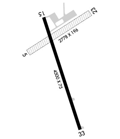
Runway Identifications
Runway Identification: 05/23Length: 2778 ft
Width: 196 ft
Surface: GRASS-GOOD CONDITION
Edge lights: Treatment: NONE
| | Runway: 05 | | Runway: 23 |
| Mag heading: | 54° | Mag heading: | 234° |
| Rwy Slope: | -.01% Down | Rwy Slope: | .01% Up |
| Approach: | | Approach: | |
| Pattern: | Left Traffic | Pattern: | Left Traffic |
| Markings: | NONSTANDARD | Markings: | NONSTANDARD |
| Marking Condition: | RWY 05-23 MARKED WITH YELLOW CONES | Marking Condition: | |
| Arresting Dev: | | Arresting Dev: | |
| Lat & Long: | N4538.7 W09519.5 | Lat. & Long.: | N4538.9 W09519.0 |
| Elev: | 1393.9 ft. MSL | Elev: | 1393.5 ft. MSL |
| TCH: | | TCH: | |
| Visual Glide Path: | | Visual Glide Path: | |
| Displaced Threshold: | No | Displaced Threshold: | No |
| Touchdown Zone: | YES | Touchdown Zone: | YES |
| Touchdown Elev.: | 1393.9 feet | Touchdown Elev.: | 1393.9 feet |
| Visual Glide Slope: | | Visual Glide Slope: | |
| RVR Equipment: | | RVR Equipment: | |
| RVV Equipment: | NO | RVV Equipment: | NO |
| Approach Lights: | | Approach Lights: | |
| REIL: | NO | REIL: | NO |
| Centerline Lights: | NO | Centerline Lights: | NO |
| Touchdown lights: | NO | Touchdown lights: | NO |
| Runway Category: | Runway with a Visual Approach | Runway Category: | Runway with a Visual Approach |
| Declared Distances: | | Declared Distances: | |
| Obstructions: | CROPS | Obstructions: | |
| Marked: | NOT Marked/Lighted | Marked: | |
| Clearance slope: | 5:1 | Clearance slope: | 20:1 |
| Obstruction height: | 8 feet AGL | Obstruction height: | |
| Dist. from runway: | 40 feet | Dist. from runway: | |
| Centerline offset: | | Centerline offset: | |
| Comments: | | Comments: | |
Runway Identification: 15/33Length: 4500 ft
Width: 75 ft
Surface: ASPHALT-GOOD CONDITION
Edge lights: Medium IntensityTreatment: NONE
| | Runway: 15 | | Runway: 33 |
| Mag heading: | 158° | Mag heading: | 338° |
| Rwy Slope: | -.32% Down | Rwy Slope: | .32% Up |
| Approach: | | Approach: | |
| Pattern: | Left Traffic | Pattern: | Left Traffic |
| Markings: | NONPRECISION INSTRUMENT | Markings: | NONPRECISION INSTRUMENT |
| Marking Condition: | GOOD | Marking Condition: | GOOD |
| Arresting Dev: | | Arresting Dev: | |
| Lat & Long: | N4538.9 W09519.4 | Lat. & Long.: | N4538.2 W09519.1 |
| Elev: | 1390.9 ft. MSL | Elev: | 1376.7 ft. MSL |
| TCH: | 33 ft. AGL | TCH: | 25 ft. AGL |
| Visual Glide Path: | 3.00 degrees | Visual Glide Path: | 3.00 degrees |
| Displaced Threshold: | No | Displaced Threshold: | No |
| Touchdown Zone: | YES | Touchdown Zone: | YES |
| Touchdown Elev.: | 1390.9 feet | Touchdown Elev.: | 1383.8 feet |
| Visual Glide Slope: | 4-Light PAPI on LEFT side of Runway | Visual Glide Slope: | 4-Light PAPI on LEFT side of Runway |
| RVR Equipment: | | RVR Equipment: | |
| RVV Equipment: | NO | RVV Equipment: | NO |
| Approach Lights: | | Approach Lights: | |
| REIL: | NO | REIL: | NO |
| Centerline Lights: | NO | Centerline Lights: | NO |
| Touchdown lights: | NO | Touchdown lights: | NO |
| Runway Category: | Runway with a Non-precision Approach | Runway Category: | Runway with a Non-precision Approach |
| Declared Distances: | | Declared Distances: | |

