Click here for more info on on SMS!

KGHM

CENTERVILLE MUNI
CENTERVILLE
TN
Time Zone: Central
Lat: N 3550.2
Long: W 08726.7
Elev: 765
Var: +03
Longest Runway: 4002
CTAF: 122.8

FBO & Flight Services info for KGHM

FBOs: Update your Fuel Prices

CENTERVILLE ARPTPh: 931-729-3032
-
Freq: 122.8
Service
Jet
100LL
SAF
MoGas
Fuel Avail: 24/7 self-serve
Full        Last Update: 04/07/2024 14:54

Self5.255.10    
If you are an FBO, call 1-203-262-1700 to update your info or email: FltPlan.Advertising@garmin.com
Advertise your FBO on FltPlan.com

Runway & Approach Info for KGHM
Rwy
Length
Land Dist**
Approach*
  Rwy
Length
Land Dist**
Approach*
02
4002x75  4002'          
 
  
20
  4002x75  3752'          
 
 * only ILS, LOC, LDA, and SDF approaches to a specific runway are shown
** For any Declared Landing Distance Available, please see A/FD or Approach plates
Runway Weight Capability (lbs.) Help
Runway IDSingle WheelDouble WheelDouble Tandem WheelDual Double Wheel
02/2021,00031,000N/AN/A
These numbers are Advisory and are not limits.   The Airport Manager should have more accurate Weight Limits
Approach Charts
Approaches    
Current Weather/Notams
Customs Information Send updates to Support@FltPlan.com
Customs Not Available
Database effective 05/16/2024
Airport Diagram of KGHM
Airport Diagram might not be current.

Facility Name: CENTERVILLE MUNI
City Name: CENTERVILLE
County: HICKMAN
State abbrev: TN
State Name: TENNESSEE
   
Ownership: PUBLICLY OWNED
Use: OPEN TO THE PUBLIC
Owner's Name: TOWN OF CENTERVILLE
Address: 102 EAST SWAN
 CENTERVILLE, TN 37033
Owner's Phone: 931-729-4246
  
Manager's Name: WOODY WOODRUFF
Address: 2650 AIRPORT RD
 CENTERVILLE, TN 37033
Phone: 931-729-3032
   
FAA Region: SOUTHERN
FAA Field Office: MEM


Sunrise / Sunset times for CENTERVILLE MUNI

DateSunriseSunset
04/23/24 Tuesday6:0619:31
04/24/24 Wednesday6:0519:31
04/25/24 Thursday6:0319:32
04/26/24 Friday6:0219:33
04/27/24 Saturday6:0119:34
04/28/24 Sunday6:0019:35
04/29/24 Monday5:5919:36
04/30/24 Tuesday5:5819:37
05/01/24 Wednesday5:5719:37
05/02/24 Thursday5:5619:38
05/03/24 Friday5:5519:39
05/04/24 Saturday5:5419:40
05/05/24 Sunday5:5319:41
05/06/24 Monday5:5219:42

Airport Facilities

Airport Attendance ScheduleMON-FRI 0730-1600; AFT HR - 615-418-2164.
Airport Status OPERATIONAL (This Status can change at any time - please check NOTAMS)
Airport Lighting ScheduleMIRL RWY 02/20 OPR DUSK-DAWN & PRESET LOW INTST; INCR INTST & ACTVT - CTAF. 0730-1600 ACTVT VGSI RWY 02 - CTAF.
Airport Storage AvailableTie Downs, Hanger
Extra Services AvailableNONE
Wind IndicatorYES - (lighted)
Control TowerNO
CTAF Frequency122.800
Unicom Frequency122.800
Rotating Beacon ColorWG
Segmented CircleYES
Landing FeeNO

Airport Inspection Data

Airport InspectedSTATE - performed by STATE AERONAUTICAL PERSONNEL
Inspection Date07/12/2023

Airport Services

Type of Fuel AvailableGrade 100LL, JET A; -10FUEL AVBL H24 WITH CREDIT CARD.
Airframe Repair ServiceNone
Power Plant Repair ServiceNone

Geographic Data

LatitudeN3550.2
LongitudeW08726.7 (ESTIMATED)
Arpt Elevation765ft (SURVEYED)
Magnetic Variation03W
3 miles Nof CENTERVILLE
Traffic Pattern Altitude
Sectional ChartATLANTA

Aircraft Data

Operations (Reported)YearlyAvg. Daily
General Aviation Transient 10003
General Aviation Local 19125
Air Taxi 00
Commerical 00
Commuter 00
Military 2001
Aircraft based on Field
General Aviation Singles 14
General Aviation Multi 3
Jet Aircraft 0
General Aviation Helicopters 0
Military Aircraft 0
Gliders 0
Ultralights 0

FAA Services

FSS on field NO
FSS tie-in JACKSON
FSS Phone 1-800-WX-BRIEF
Who issues Notams MKL
Notam D service at airport YES
ARTCC Name MEMPHIS

Federal Status

Airport Certification
Aircraft Rescue & Firefighting IndexNone
Airport of EntryNo
Custom Landing RightsNo
Joint Civil/MilitaryNo
Military Landing rightsNo

Federal Agreements

NATIONAL PLAN OF INTEGRATED AIRPORT SYSTEMS (NPIAS)

Remarks

FOR CD CTC MEMPHIS ARTCC AT 901-368-8453/8449.
Airport Communications & Frequencies:
CTAF Frequency:
122.800
Unicom Frequency:
122.800
Remarks
  • APCH/DEP SVC PRVDD BY MEMPHIS ARTCC ON FREQS 125.85/379.25 (CENTERVILLE RCAG).
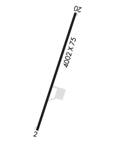
  • Runway Identifications
    Runway Identification: 02/20
    Length: 4002 ft
    Width: 75 ft
    Surface: ASPHALT-GOOD CONDITION
    Edge lights: Medium Intensity

    Treatment: NONE

     Runway: 02   Runway: 20
    Mag heading: 21°Mag heading: 201°
    Rwy Slope: .00%Rwy Slope: .00%
    Approach: Approach:
    Pattern: Left TrafficPattern: Left Traffic
    Markings: NONPRECISION INSTRUMENTMarkings: NONPRECISION INSTRUMENT
    Marking Condition: GOODMarking Condition: GOOD
    Arresting Dev: Arresting Dev:
    Lat & Long: N3549.9  W08726.8Lat. & Long.: N3550.6  W08726.6
    Elev: 765.0 ft. MSLElev: 765.0 ft. MSL
    TCH: 43 ft. AGLTCH: 53 ft. AGL
    Visual Glide Path: 4.00 degreesVisual Glide Path: 4.00 degrees
    Displaced Threshold: NoDisplaced Threshold: 250 feet
    Touchdown Zone: YESTouchdown Zone: YES
    Touchdown Elev.: 764.9 feetTouchdown Elev.: 764.9 feet
    Visual Glide Slope: 4-Light PAPI on LEFT side of RunwayVisual Glide Slope: 4-Light PAPI on LEFT side of Runway; PAPI UNUSBL BYD 5 DEGS LEFT OF CNTRLN.
    RVR Equipment: RVR Equipment:
    RVV Equipment: NORVV Equipment: NO
    Approach Lights: Approach Lights:
    REIL: YESREIL: YES
    Centerline Lights: NOCenterline Lights: NO
    Touchdown lights: NOTouchdown lights: NO
    Runway Category: Runway with a Non-precision ApproachRunway Category: Runway with a Visual Approach
    Declared Distances: Declared Distances:
    Obstructions: TREESObstructions: TREE
    Marked: NOT Marked/LightedMarked: NOT Marked/Lighted
    Clearance slope: 10:1Clearance slope: 13:1
    Obstruction height: 72 feet AGLObstruction height: 98 feet AGL
    Dist. from runway: 983 feetDist. from runway: 1519 feet
    Centerline offset: 980 right of centerlineCenterline offset: 171 feet right of centerline
    Comments: Comments:
    C:1/P: