
| ||||||||||||||||||||||||||||||||||||||||||||
| ||||||||||||||||||||||||||||||||||||||||||||
| ||||||||||||||||||||||||||||||||||||||||||||
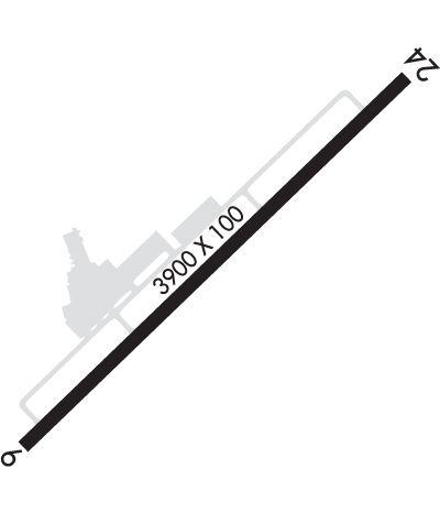
| Rwy | Rwy | |||||||
| 3900x100 | 3600' | 3900x100 | 3600' | |||||
| Runway ID | Single Wheel | Double Wheel | Double Tandem Wheel | Dual Double Wheel |
| 06/24 | 12,500 | N/A | N/A | N/A |
| These numbers are Advisory and are not limits. The Airport Manager should have more accurate Weight Limits | ||||
 Airport Diagram might not be current. | |
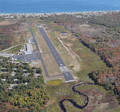
| Facility Name: | MARSHFIELD MUNI - GEORGE HARLOW FLD |
| City Name: | MARSHFIELD |
| County: | PLYMOUTH |
| State abbrev: | MA |
| State Name: | MASSACHUSETTS |
| Ownership: | PUBLICLY OWNED |
| Use: | OPEN TO THE PUBLIC |
| Owner's Name: | TOWN OF MARSHFIELD |
| Address: | 870 MORAINE ST |
| MARSHFIELD, MA 02050 | |
| Owner's Phone: | 781-536-2500 |
| Manager's Name: | JASON TIBBETTS |
| Address: | 93 OLD COLONY LANE |
| MARSHFIELD, MA 02050 | |
| Phone: | 781-834-4928 |
| FAA Region: | NEW ENGLAND |
| FAA Field Office: | NONE |
| Date | Sunrise | Sunset |
|---|---|---|
| 04/18/24 Thursday | 5:56 | 19:28 |
| 04/19/24 Friday | 5:55 | 19:29 |
| 04/20/24 Saturday | 5:53 | 19:30 |
| 04/21/24 Sunday | 5:52 | 19:31 |
| 04/22/24 Monday | 5:50 | 19:33 |
| 04/23/24 Tuesday | 5:49 | 19:34 |
| 04/24/24 Wednesday | 5:47 | 19:35 |
| 04/25/24 Thursday | 5:46 | 19:36 |
| 04/26/24 Friday | 5:44 | 19:37 |
| 04/27/24 Saturday | 5:43 | 19:38 |
| 04/28/24 Sunday | 5:42 | 19:39 |
| 04/29/24 Monday | 5:40 | 19:40 |
| 04/30/24 Tuesday | 5:39 | 19:41 |
| 05/01/24 Wednesday | 5:37 | 19:43 |
| Airport Attendance Schedule | 7 Days A Week 0800-DUSK |
| Airport Status | OPERATIONAL (This Status can change at any time - please check NOTAMS) |
| Airport Lighting Schedule | ACTVT PAPI RWY 6 & 24 - CTAF. |
| Airport Storage Available | Tie Downs, Hanger |
| Extra Services Available | Charter, Flight Instruction, Aircraft Rental, Aircraft Sales |
| Wind Indicator | YES - (unlit) |
| Control Tower | NO |
| CTAF Frequency | 122.800 |
| Unicom Frequency | 122.800 |
| Rotating Beacon Color | WG |
| Segmented Circle | YES |
| Landing Fee | NO |
| Airport Inspected | STATE - performed by STATE AERONAUTICAL PERSONNEL |
| Inspection Date | 11/21/2022 |
| Type of Fuel Available | Grade 100LL, JET A (freeze point -40C), JET A |
| Airframe Repair Service | MAJOR |
| Power Plant Repair Service | MAJOR |
| Latitude | N4205.8 |
| Longitude | W07040.4 (ESTIMATED) |
| Arpt Elevation | 8ft (SURVEYED) |
| Magnetic Variation | 16W |
| 2 miles E | of MARSHFIELD |
| Traffic Pattern Altitude | |
| Sectional Chart | NEW YORK |
| Operations (Reported) | Yearly | Avg. Daily |
|---|---|---|
| General Aviation Transient | 6000 | 16 |
| General Aviation Local | 12000 | 33 |
| Air Taxi | 1500 | 4 |
| Commerical | 0 | 0 |
| Commuter | 0 | 0 |
| Military | 1200 | 3 |
| Aircraft based on Field | |
|---|---|
| General Aviation Singles | 22 |
| General Aviation Multi | 1 |
| Jet Aircraft | 3 |
| General Aviation Helicopters | 0 |
| Military Aircraft | 0 |
| Gliders | 0 |
| Ultralights | 0 |
| FSS on field | NO |
| FSS tie-in | BRIDGEPORT |
| FSS Phone | 1-800-WX-BRIEF |
| Who issues Notams | BDR |
| Notam D service at airport | YES |
| ARTCC Name | BOSTON |
| Airport Certification | |
| Aircraft Rescue & Firefighting Index | None |
| Airport of Entry | No |
| Custom Landing Rights | No |
| Joint Civil/Military | No |
| Military Landing rights | YES |
| NATIONAL PLAN OF INTEGRATED AIRPORT SYSTEMS (NPIAS) |
| GRANT AGREEMENTS UNDER FAAP/ADAP/AIP |
| ASSURANCES PURSUANT TO TITLE VI, CIVIL RIGHTS ACT OF 1964 |
| BIRDS, DEER & WILDLIFE ON & INVOF ARPT. |
| ALL ENG RUNUPS AT MIDFIELD RAMP. |
| VOLUNTARY NOISE ABATEMENT PROCS IN EFCT, NO TGLS BTN 2100 & 0730 LCL. |
| FLT TRNG ACTVY. |
| AFT HRS SVC BY REQ. |
| SFC CONDS UNMNT & SNOW REMOVAL NA APRXLY 1930-0900. |
| FOR CD CTC BOSTON APCH AT 603-594-5554. |
Airport Communications & Frequencies:
| |||||||||||||
| Runway: 06 | Runway: 24 | ||
| Mag heading: | 62° | Mag heading: | 242° |
| Rwy Slope: | -.04% Down | Rwy Slope: | .04% Up |
| Approach: | Approach: | ||
| Pattern: | Left Traffic | Pattern: | Left Traffic |
| Markings: | NONPRECISION INSTRUMENT | Markings: | NONPRECISION INSTRUMENT |
| Marking Condition: | GOOD | Marking Condition: | GOOD |
| Arresting Dev: | Arresting Dev: | ||
| Lat & Long: | N4205.6 W07040.7 | Lat. & Long.: | N4206.1 W07040.1 |
| Elev: | 5.2 ft. MSL | Elev: | 3.5 ft. MSL |
| TCH: | 43 ft. AGL | TCH: | 40 ft. AGL |
| Visual Glide Path: | 3.00 degrees | Visual Glide Path: | 3.00 degrees |
| Displaced Threshold: | 300 feet | Displaced Threshold: | 300 feet |
| Touchdown Zone: | YES | Touchdown Zone: | YES |
| Touchdown Elev.: | 8.9 feet | Touchdown Elev.: | 8.9 feet |
| Visual Glide Slope: | 4-Light PAPI on RIGHT side of Runway | Visual Glide Slope: | 4-Light PAPI on RIGHT side of Runway |
| RVR Equipment: | RVR Equipment: | ||
| RVV Equipment: | NO | RVV Equipment: | NO |
| Approach Lights: | Approach Lights: | ||
| REIL: | YES | REIL: | YES |
| Centerline Lights: | NO | Centerline Lights: | NO |
| Touchdown lights: | NO | Touchdown lights: | NO |
| Runway Category: | Runway with a Non-precision Approach | Runway Category: | Runway with a Non-precision Approach |
| Declared Distances: | TORA:3900' TODA:3900' ASDA:3600' LDA:3300' | Declared Distances: | TORA:3900' TODA:3900' ASDA:3600' LDA:3300' |
| Obstructions: | TREES | Obstructions: | TREES |
| Marked: | NOT Marked/Lighted | Marked: | NOT Marked/Lighted |
| Clearance slope: | 20:1 | Clearance slope: | 20:1 |
| Obstruction height: | 75 feet AGL | Obstruction height: | 30 feet AGL |
| Dist. from runway: | 1700 feet | Dist. from runway: | 800 feet |
| Centerline offset: | 130 right of centerline | Centerline offset: | |
| Comments: | Comments: |