Current Weather/Notams (Metars, TAFs, Notams, NWS Forecast, PIREPS, and nearby weather)
Customs Information Send updates to Support@FltPlan.com
Customs Not Available
Database effective 05/16/2024
Airport Diagram might not be current.
|
| Facility Name: | GRINNELL RGNL |
| City Name: | GRINNELL |
| County: | POWESHIEK |
| State abbrev: | IA |
| State Name: | IOWA |
| | |
| Ownership: | PUBLICLY OWNED |
| Use: | OPEN TO THE PUBLIC |
| Owner's Name: | CITY OF GRINNELL |
| Address: | CITY HALL 927 4TH AVE |
| | GRINNELL, IA 50112 |
| Owner's Phone: | 641-236-2605 |
| | |
| Manager's Name: | RON LOWRY |
| Address: | 1607 W ST S |
| | GRINNELL, IA 50112 |
| Phone: | 641-236-0188 |
| | |
| FAA Region: | CENTRAL |
| FAA Field Office: | NONE |
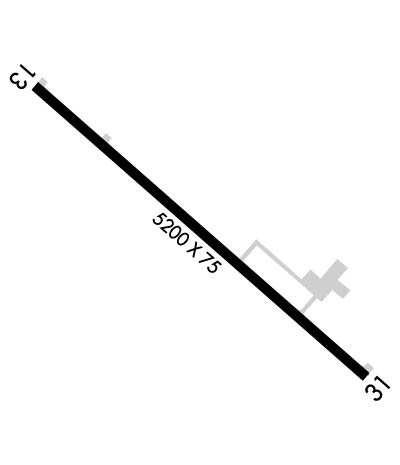
Runway Identifications
Runway Identification: 13/31Length: 5200 ft
Width: 75 ft
Surface: CONCRETE
Edge lights: Medium IntensityTreatment: GROOVED
Weight: PCN 12 /R/C/W/U
| | Runway: 13 | | Runway: 31 |
| Mag heading: | 129° | Mag heading: | 309° |
| Rwy Slope: | .37% Up | Rwy Slope: | -.37% Down |
| Approach: | | Approach: | |
| Pattern: | Left Traffic | Pattern: | Left Traffic |
| Markings: | NONPRECISION INSTRUMENT | Markings: | NONPRECISION INSTRUMENT |
| Marking Condition: | GOOD | Marking Condition: | GOOD |
| Arresting Dev: | | Arresting Dev: | |
| Lat & Long: | N4142.9 W09244.6 | Lat. & Long.: | N4142.3 W09243.7 |
| Elev: | 988.8 ft. MSL | Elev: | 1007.8 ft. MSL |
| TCH: | 40 ft. AGL | TCH: | 40 ft. AGL |
| Visual Glide Path: | 3.00 degrees | Visual Glide Path: | 3.00 degrees |
| Displaced Threshold: | 200 feet | Displaced Threshold: | 200 feet |
| Touchdown Zone: | YES | Touchdown Zone: | YES |
| Touchdown Elev.: | 1005.5 feet | Touchdown Elev.: | 1008.4 feet |
| Visual Glide Slope: | 2-Light PAPI on LEFT side of Runway | Visual Glide Slope: | 2-Light PAPI on LEFT side of Runway |
| RVR Equipment: | | RVR Equipment: | |
| RVV Equipment: | NO | RVV Equipment: | NO |
| Approach Lights: | | Approach Lights: | |
| REIL: | YES | REIL: | YES |
| Centerline Lights: | NO | Centerline Lights: | NO |
| Touchdown lights: | NO | Touchdown lights: | NO |
| Runway Category: | Runway with a Non-precision Approach having visibility minimums greater than 3/4 mile | Runway Category: | Runway with a Non-precision Approach having visibility minimums greater than 3/4 mile |
| Declared Distances: | | Declared Distances: | |
| Obstructions: | TREE | Obstructions: | TREE |
| Marked: | NOT Marked/Lighted | Marked: | NOT Marked/Lighted |
| Clearance slope: | 25:1; RWY 13 APCH SLP 35:1 TO DSPLCD THR. | Clearance slope: | 17:1; RWY 31 APCH SLP 25:1 TO DSPLCD THR. |
| Obstruction height: | 40 feet AGL | Obstruction height: | 52 feet AGL |
| Dist. from runway: | 1230 feet | Dist. from runway: | 1109 feet |
| Centerline offset: | 53 left of centerline | Centerline offset: | 84 feet left of centerline |
| Comments: | | Comments: | |

