Click here for more info on on SMS!

KGFL

FLOYD BENNETT MEMORIAL
GLENS FALLS
NY
Time Zone: Eastern
Lat: N 4320.5
Long: W 07336.6
Elev: 328
Var: +14
Longest Runway: 5000
AWOS: 119.92
CTAF: 123.0

FBO & Flight Services info for KGFL

FBOs: Update your Fuel Prices

  click here  
Rich Air's new FBO at Floyd Bennett Memorial GFL features a luxurious pilot lounge, briefing room and a spacious lobby with HD TV. With an ILS, 5000' primary runway, 48,000 sq. ft. of hangar space and competitive prices, GFL is your gateway airport to the Adirondacks! Let our friendly staff assist with all of your reservations. Lake George, Saratoga Springs, skiing and golf are minutes away!
Ph: 518-798-3091 Fax: 518-615-0774 Freq: 123.0WebsiteE-Mail
                               
Service
Jet
100LL
SAF
MoGas
Fuel Avail: Daily, 8:00 AM-6:00 PM (SS Fuel 24Hrs) After hours call out available: (518) 798-3091.
Full7.19      Last Update: 03/30/2024 16:31

PRIST PREMIXED All taxes included
Self  6.84    
Misc. Info: Address: 443 QUEENSBURY AVE   QUEENSBURY, NY 12804

ASOSPh: 518-743-1728
-
Freq: 119.92  
If you are an FBO, call 1-203-262-1700 to update your info or email: FltPlan.Advertising@garmin.com
Advertise your FBO on FltPlan.com

Runway & Approach Info for KGFL
Rwy
Length
Land Dist**
Approach*
  Rwy
Length
Land Dist**
Approach*
01
5000x150  5000'          
ILS
 110.70 - 012°  
  
19
  5000x150  5000'          
 
12
3999x100  3999'          
 
  
30
  3999x100  3999'          
 
 * only ILS, LOC, LDA, and SDF approaches to a specific runway are shown
** For any Declared Landing Distance Available, please see A/FD or Approach plates
Runway Weight Capability (lbs.) Help
Runway IDSingle WheelDouble WheelDouble Tandem WheelDual Double Wheel
01/1980,000110,000180,000N/A
12/3039,00053,00076,000N/A
These numbers are Advisory and are not limits.   The Airport Manager should have more accurate Weight Limits
Approach Charts
Approaches    
Current Weather/Notams
Customs Information Send updates to Support@FltPlan.com
Phone 518-431-0200
Fax N/A

Comments 2 hrs advance notice required. On-call basis *Cargo coverage upon prior arrangement *Call prior to 1500 on preceding weekday. **After hours call 800-973-2867.
Database effective 04/18/2024
Airport Diagram of KGFL
Airport Diagram might not be current.

Facility Name: FLOYD BENNETT MEML
City Name: GLENS FALLS
County: WARREN
State abbrev: NY
State Name: NEW YORK
   
Ownership: PUBLICLY OWNED
Use: OPEN TO THE PUBLIC
Owner's Name: WARREN COUNTY
Address: 4028 MAIN ST
 WARRENSBURG, NY 12885-0010
Owner's Phone: 518-824-8830
  
Manager's Name: ROBIN MAPP
Address: 443 QUEENSBURY AVE, RM 201
 QUEENSBURY, NY 12804
Phone: 518-792-5995
   
FAA Region: EASTERN
FAA Field Office: NYC
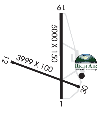

Sunrise / Sunset times for FLOYD BENNETT MEML

DateSunriseSunset
04/19/24 Friday6:0419:43
04/20/24 Saturday6:0319:44
04/21/24 Sunday6:0119:45
04/22/24 Monday6:0019:47
04/23/24 Tuesday5:5819:48
04/24/24 Wednesday5:5719:49
04/25/24 Thursday5:5519:50
04/26/24 Friday5:5419:51
04/27/24 Saturday5:5219:52
04/28/24 Sunday5:5119:54
04/29/24 Monday5:4919:55
04/30/24 Tuesday5:4819:56
05/01/24 Wednesday5:4619:57
05/02/24 Thursday5:4519:58

Airport Facilities

Airport Attendance Schedule7 Days A Week 0800-1800
Airport Status OPERATIONAL (This Status can change at any time - please check NOTAMS)
Airport Lighting ScheduleACTVT MALSR RWY 01; PAPI RWY 01, 19, 12, 30; HIRL RWY 01/19; MIRL RWY 12/30; TWY LGTS - CTAF.
Airport Storage AvailableTie Downs, Hanger
Extra Services AvailableCargo Handling, Charter, Flight Instruction, Aircraft Rental, Aircraft Sales
Wind IndicatorYES - (lighted)
Control TowerNO
CTAF Frequency123.000
Unicom Frequency123.000
Rotating Beacon ColorWG
Segmented CircleNO
Landing FeeNO

Airport Inspection Data

Airport InspectedFEDERAL - performed by FAA AIRPORTS FIELD PERSONNEL
Inspection Date05/04/2023

Airport Services

Type of Fuel AvailableGrade 100LL, JET A (freeze point -40C); -10SELF-SERVICE 100LL FUEL AVBL. FULL SERVICE FUELING AVBL AFTER HRS BY PRE-ARRANGEMENT; CALL 518-798-3091.
Airframe Repair ServiceMAJOR
Power Plant Repair ServiceMAJOR

Geographic Data

LatitudeN4320.5
LongitudeW07336.6 (ESTIMATED)
Arpt Elevation328ft (SURVEYED)
Magnetic Variation14W
3 miles NEof GLENS FALLS
Traffic Pattern Altitude
Sectional ChartNEW YORK

Aircraft Data

Operations (Reported)YearlyAvg. Daily
General Aviation Transient 537215
General Aviation Local 981127
Air Taxi 770921
Commerical 00
Commuter 00
Military 4671
Aircraft based on Field
General Aviation Singles 42
General Aviation Multi 1
Jet Aircraft 2
General Aviation Helicopters 0
Military Aircraft 0
Gliders 0
Ultralights 0

FAA Services

FSS on field NO
FSS tie-in BURLINGTON
FSS Phone 1-800-WX-BRIEF
Who issues Notams GFL
Notam D service at airport YES
ARTCC Name BOSTON

Federal Status

Airport CertificationPPR 48 HRS FOR ACFT OPS WITH MORE THAN 30 PAX SEATS CALL AMGR 518-792-5995.
Aircraft Rescue & Firefighting IndexAIRPORT HAS A CERTIFICATE UNDER CFR PART 139
Airport of EntryNo
Custom Landing RightsYES
Joint Civil/MilitaryNo
Military Landing rightsYES

Federal Agreements

NATIONAL PLAN OF INTEGRATED AIRPORT SYSTEMS (NPIAS)
GRANT AGREEMENTS UNDER FAAP/ADAP/AIP
ASSURANCES PURSUANT TO TITLE VI, CIVIL RIGHTS ACT OF 1964
AGREEMENT UNDER DLAND OR DCLA HAS EXPIRED.

Remarks

RWYS12 & 19 APCHS OBSCURED FM ONE ANOTHER DUE TO HIGH GND.
PJE AIRSPACE DEFINED AS 5 NM RADIUS OF GFL.
COLD TEMPERATURE AIRPORT. ALTITUDE CORRECTION REQUIRED AT OR BELOW -19C.
FOR AFT HRS ACFT MAINT ASSISTANCE CALL 518-798-3091.
NOISE SENSITIVE AREA 1.5 MILES NORTH.
USE NBAA NOISE ABATEMENT PROCEDURES.
RCMD NO TOUCH AND GO OPS FM 2200Z-1200Z.
FOR CD CTC ALBANY APCH AT 518-862-2299.
FOUR OBSTN LGT POLES 1-1/2 MI TO 1-3/4 MI N OF RWY 19.
BIRDS/DEER ON & INVOF ARPT.
RWY 01 DSGND CALM WIND RWY.
GRASS CUTTING EQPT OPS ADJACENT TO ALL OPERATIONAL SFCS DALGT HRS MAY THRU OCT.
ULTRA-LIGHT ACT ON & INVOF ARPT.
ULTRA-LIGHT ACFT USE 500 FT AGL LEFT TFC FOR ALL RWYS.
DRG PDS OF SNOW REMOVAL OPNS NOV 1-APR 1 ACFT MUST CTC ARPT ON FREQ 123.0 10 MINS PRIOR TO LDG.
RSCD MAY NOT BE MONITORED OR REPORTED WHEN THE ARPT IS UNATNDD.
Airport Communications & Frequencies:
CTAF Frequency:
123.000
Unicom Frequency:
123.000
ALBANY Primary Approach Frequencies:  
132.825
307.2
ALBANY Primary Departure Frequencies:  
132.825
307.2
Runway Identifications
Runway Identification: 01/19
Length: 5000 ft
Width: 150 ft
Surface: ASPHALT
Edge lights: High Intensity

Treatment: GROOVED
Weight: PCN 48 /F/A/X/T

 Runway: 01   Runway: 19
Mag heading: 12°Mag heading: 192°
Rwy Slope: .10% UpRwy Slope: -.10% Down
Approach: ILSApproach:
Pattern: Left TrafficPattern: Left Traffic
Markings: PRECISION INSTRUMENTMarkings: NONPRECISION INSTRUMENT
Marking Condition: GOODMarking Condition: GOOD
Arresting Dev: Arresting Dev:
Lat & Long: N4320.1  W07336.5Lat. & Long.: N4321.0  W07336.6
Elev: 321.5 ft. MSLElev: 326.5 ft. MSL
TCH: 53 ft. AGLTCH: 50 ft. AGL
Visual Glide Path: 3.00 degreesVisual Glide Path: 3.00 degrees
Displaced Threshold: NoDisplaced Threshold: No
Touchdown Zone: YESTouchdown Zone: YES
Touchdown Elev.: 323.8 feetTouchdown Elev.: 326.6 feet
Visual Glide Slope: 4-Light PAPI on LEFT side of RunwayVisual Glide Slope: 4-Light PAPI on LEFT side of Runway
RVR Equipment: RVR Equipment:
RVV Equipment: NORVV Equipment: NO
Approach Lights: MALSR - 1,400 foot medium intensity approach lighting system with runway alignment indicator lightsApproach Lights:
REIL: NOREIL: NO
Centerline Lights: NOCenterline Lights: NO
Touchdown lights: NOTouchdown lights: NO
Runway Category: Precision Instrument RunwayRunway Category: Runway with a Non-precision Approach having visibility minimums greater than 3/4 mile
Declared Distances: TORA:5000' TODA:5000' ASDA:5000' LDA:5000'Declared Distances: TORA:5000' TODA:5000' ASDA:5000' LDA:5000'
Obstructions: Obstructions: TREES
Marked: Marked: NOT Marked/Lighted
Clearance slope: 34:1Clearance slope: 26:1
Obstruction height: Obstruction height: 57 feet AGL
Dist. from runway: Dist. from runway: 1715 feet
Centerline offset: Centerline offset: 315 feet right of centerline
Comments: Comments:
Runway Identification: 12/30
Length: 3999 ft
Width: 100 ft
Surface: ASPHALT-GOOD CONDITION
Edge lights: Medium Intensity

Treatment: NONE
Weight: PCN 48 /F/A/X/T

 Runway: 12   Runway: 30
Mag heading: 124°Mag heading: 304°
Rwy Slope: -.11% DownRwy Slope: .11% Up
Approach: Approach:
Pattern: Left TrafficPattern: Left Traffic
Markings: NONPRECISION INSTRUMENTMarkings: NONPRECISION INSTRUMENT
Marking Condition: GOODMarking Condition: GOOD
Arresting Dev: Arresting Dev:
Lat & Long: N4320.5  W07337.1Lat. & Long.: N4320.3  W07336.3
Elev: 328.4 ft. MSLElev: 324.1 ft. MSL
TCH: 55 ft. AGLTCH: 45 ft. AGL
Visual Glide Path: 3.85 degreesVisual Glide Path: 3.00 degrees
Displaced Threshold: NoDisplaced Threshold: No
Touchdown Zone: YESTouchdown Zone: YES
Touchdown Elev.: 328.4 feetTouchdown Elev.: 325.3 feet
Visual Glide Slope: 4-Light PAPI on LEFT side of RunwayVisual Glide Slope: 4-Light PAPI on LEFT side of Runway
RVR Equipment: RVR Equipment:
RVV Equipment: NORVV Equipment: NO
Approach Lights: Approach Lights:
REIL: NOREIL: NO
Centerline Lights: NOCenterline Lights: NO
Touchdown lights: NOTouchdown lights: NO
Runway Category: Runway with a Non-precision Approach having visibility minimums greater than 3/4 mileRunway Category: Runway with a Non-precision Approach having visibility minimums greater than 3/4 mile
Declared Distances: TORA:3999' TODA:3999' ASDA:3999' LDA:3999'Declared Distances: TORA:3999' TODA:3999' ASDA:3999' LDA:3999'
Obstructions: TREESObstructions: TREES
Marked: NOT Marked/LightedMarked: NOT Marked/Lighted
Clearance slope: 19:1Clearance slope: 23:1
Obstruction height: 147 feet AGLObstruction height: 71 feet AGL
Dist. from runway: 2885 feetDist. from runway: 1870 feet
Centerline offset: 567 left of centerlineCenterline offset:
Comments: Comments:
C:12/P: