Current Weather/Notams (Metars, TAFs, Notams, NWS Forecast, PIREPS, and nearby weather)
Customs Information Send updates to Support@FltPlan.com
Customs Not Available
Database effective 04/18/2024
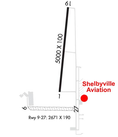
Airport Diagram might not be current. Facility Name: SHELBYVILLE MUNI City Name: SHELBYVILLE County: SHELBY State abbrev: IN State Name: INDIANA Ownership: PUBLICLY OWNED Use: OPEN TO THE PUBLIC Owner's Name: SHELBYVILLE BOAC Address: 44 W WASHINGTON ST SHELBYVILLE, IN 46176 Owner's Phone: 317-398-6624 Manager's Name: MARANDA SMITH; GEZ@AEROMANAGEMENTGROUP.COM Address: 3529 N 100 WEST SHELBYVILLE, IN 46176 Phone: 317-392-1284 FAA Region: GREAT LAKES FAA Field Office: CHI
Runway Identifications Help
Runway Identification: 01/19 Length: 5000 ftWidth: 100 ftSurface: ASPHALT-GOOD CONDITIONEdge lights: Medium Intensity Treatment: GROOVED Runway: 01 Runway: 19 Mag heading: 9° Mag heading: 189° Rwy Slope: .02% Up Rwy Slope: -.02% Down Approach: Approach: Pattern: Left Traffic Pattern: Left Traffic Markings: NONPRECISION INSTRUMENT Markings: NONPRECISION INSTRUMENT Marking Condition: GOOD Marking Condition: GOOD Arresting Dev: Arresting Dev: Lat & Long: N3934.8 W08548.3 Lat. & Long.: N3935.6 W08548.2 Elev: 801.3 ft. MSL Elev: 802.3 ft. MSL TCH: 25 ft. AGL TCH: 38 ft. AGL Visual Glide Path: 3.00 degrees Visual Glide Path: 3.00 degrees Displaced Threshold: No Displaced Threshold: No Touchdown Zone: YES Touchdown Zone: YES Touchdown Elev.: 801.6 feet Touchdown Elev.: 802.5 feet Visual Glide Slope: 2-Light PAPI on LEFT side of Runway Visual Glide Slope: 4-BOX VASI ON LEFT SIDE OF RUNWAY RVR Equipment: RVR Equipment: RVV Equipment: NO RVV Equipment: NO Approach Lights: Approach Lights: REIL: YES REIL: YES Centerline Lights: NO Centerline Lights: NO Touchdown lights: NO Touchdown lights: NO Runway Category: Runway with a Non-precision Approach Runway Category: Runway with a Non-precision Approach Declared Distances: Declared Distances:
Runway Identification: 09/27 Length: 2671 ftWidth: 190 ftSurface: GRASS-GOOD CONDITIONEdge lights: Treatment: NONE Runway: 09 Runway: 27 Mag heading: 96° Mag heading: 276° Rwy Slope: .37% Up Rwy Slope: -.37% Down Approach: Approach: Pattern: Left Traffic Pattern: Left Traffic Markings: NONE Markings: NONE Marking Condition: Marking Condition: RWY BEGINS W SIDE OF TWY A; GRASS LINE MARKS RWY EDGES. Arresting Dev: Arresting Dev: Lat & Long: N3934.6 W08548.7 Lat. & Long.: N3934.6 W08548.1 Elev: 790.0 ft. MSL Elev: 800.0 ft. MSL TCH: TCH: Visual Glide Path: Visual Glide Path: Displaced Threshold: 446 feet; RY 09/27 DSPLCD THLDS MKD WITH YELLOW CONES. Displaced Threshold: 289 feet Touchdown Zone: YES Touchdown Zone: YES Touchdown Elev.: 793.0 feet Touchdown Elev.: 800.0 feet Visual Glide Slope: Visual Glide Slope: RVR Equipment: RVR Equipment: RVV Equipment: NO RVV Equipment: NO Approach Lights: Approach Lights: REIL: NO REIL: NO Centerline Lights: NO Centerline Lights: NO Touchdown lights: NO Touchdown lights: NO Runway Category: Runway with a Visual Approach Runway Category: Runway with a Visual Approach Declared Distances: Declared Distances: Obstructions: ROAD Obstructions: BLDG Marked: NOT Marked/Lighted Marked: LIGHTED Clearance slope: 10:1; APCH SLOPE 40:1 AT DSPLCD THR. Clearance slope: 14:1; APCH RATIO 27:1 TO DSPLCD THLD. Obstruction height: 150 feet AGL Obstruction height: 23 feet AGL Dist. from runway: 15 feet Dist. from runway: 325 feet Centerline offset: Centerline offset: 120 feet right of centerline Comments: Comments: