Current Weather/Notams (Metars, TAFs, Notams, NWS Forecast, PIREPS, and nearby weather)
Customs Information Send updates to Support@FltPlan.com
Customs Not Available
Database effective 05/16/2024
Airport Diagram might not be current.
|
| Facility Name: | GLENDALE MUNI |
| City Name: | GLENDALE |
| County: | MARICOPA |
| State abbrev: | AZ |
| State Name: | ARIZONA |
| | |
| Ownership: | PUBLICLY OWNED |
| Use: | OPEN TO THE PUBLIC |
| Owner's Name: | CITY OF GLENDALE |
| Address: | 5850 W GLENDALE AVE. |
| | GLENDALE, AZ 85301 |
| Owner's Phone: | 623-930-2188 |
| | |
| Manager's Name: | MATTHEW SMITH |
| Address: | 6801 N. GLEN HARBOR BLVD 201 |
| | GLENDALE, AZ 85307 |
| Phone: | 623-930-4744; 623-930-2188 FM 0800-1700; 602-980-0433 FM 0600-2000. |
| | |
| FAA Region: | WESTERN-PACIFIC |
| FAA Field Office: | PHX |
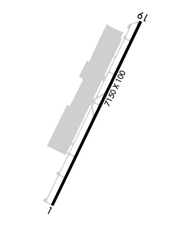
Runway Identifications
Runway Identification: 01/19Length: 7150 ft
Width: 100 ft
Surface: ASPHALT-GOOD CONDITION
Edge lights: Medium IntensityTreatment: NONE
| | Runway: 01 | | Runway: 19 |
| Mag heading: | 14° | Mag heading: | 194° |
| Rwy Slope: | .42% Up | Rwy Slope: | -.42% Down |
| Approach: | | Approach: | |
| Pattern: | Right Traffic | Pattern: | Left Traffic |
| Markings: | BASIC | Markings: | NONPRECISION INSTRUMENT |
| Marking Condition: | GOOD | Marking Condition: | GOOD |
| Arresting Dev: | | Arresting Dev: | |
| Lat & Long: | N3331.1 W11218.0 | Lat. & Long.: | N3332.1 W11217.4 |
| Elev: | 1041.4 ft. MSL | Elev: | 1071.3 ft. MSL |
| TCH: | 38 ft. AGL | TCH: | 30 ft. AGL |
| Visual Glide Path: | 3.00 degrees | Visual Glide Path: | 3.00 degrees |
| Displaced Threshold: | 701 feet | Displaced Threshold: | 1001 feet |
| Touchdown Zone: | YES | Touchdown Zone: | YES |
| Touchdown Elev.: | 1049.0 feet | Touchdown Elev.: | 1065.4 feet |
| Visual Glide Slope: | 2-Light PAPI on LEFT side of Runway | Visual Glide Slope: | 2-Light PAPI on LEFT side of Runway |
| RVR Equipment: | | RVR Equipment: | |
| RVV Equipment: | NO | RVV Equipment: | NO |
| Approach Lights: | | Approach Lights: | |
| REIL: | YES | REIL: | YES |
| Centerline Lights: | NO | Centerline Lights: | NO |
| Touchdown lights: | NO | Touchdown lights: | NO |
| Runway Category: | Runway with a Non-precision Approach having visibility minimums greater than 3/4 mile | Runway Category: | Runway with a Non-precision Approach having visibility minimums greater than 3/4 mile |
| Declared Distances: | TORA:7150' TODA:7150' ASDA:6980' LDA:6279' | Declared Distances: | TORA:7150' TODA:7150' ASDA:7116' LDA:6115' |
| Obstructions: | ROAD | Obstructions: | FENCE |
| Marked: | NOT Marked/Lighted | Marked: | NOT Marked/Lighted |
| Clearance slope: | +13 FT ROAD 135 FT FM DTHR 275 FT R; APCH SLOPE 10:1 AT DTHR. | Clearance slope: | +14 FT ROAD 470 FT FM DTHR 310 FT L; APCH SLOPE 33:1 AT DTHR. |
| Obstruction height: | 13 feet AGL | Obstruction height: | 6 feet AGL |
| Dist. from runway: | 201 feet | Dist. from runway: | 201 feet |
| Centerline offset: | 150 right of centerline | Centerline offset: | 150 feet right of centerline |
| Comments: | +13 FT ROAD 0-200 FT FM RWY END 150 FT R. | Comments: | +12 FT BLAST FENCE 95 FT FM RWY END BOTH SIDES. |