Click here for more info on on SMS!

KGED

DELAWARE COASTAL AIRPORT
GEORGETOWN
DE
Time Zone: Eastern
Lat: N 3841.3
Long: W 07521.6
Elev: 53
Var: +12
Longest Runway: 5500
Clr Del: 125.55 GCO
AWOS: 118.37
CTAF: 123.0

FBO & Flight Services info for KGED

FBOs: Update your Fuel Prices
Skyline Aviation is a full service FBO offering many amenities to make your visit both convenient and enjoyable. Whether you are visiting for fuel, food or an overnight stay, our friendly, knowledgeable staff will provide you with superior customer service from the moment your wheels touch the runway until your departure.
Ph: 302-855-2355 Fax: 302-855-9378 Freq: 123.0WebsiteE-Mail
Service
Jet
100LL
SAF
MoGas
Fuel Avail: PRIST PREMIXED.
Full6.136.20    Last Update: 04/15/2024 11:40

Self        
Misc. Info: Address: 21553 RUDDER LANE,   GEORGETOWN, DE 19947

ASOSPh: 302-856-2927
-
Freq: 118.37  
If you are an FBO, call 1-203-262-1700 to update your info or email: FltPlan.Advertising@garmin.com
Advertise your FBO on FltPlan.com

Runway & Approach Info for KGED
Rwy
Length
Land Dist**
Approach*
  Rwy
Length
Land Dist**
Approach*
04
5500x150  5130'          
 
  
22
  5500x150  5331'          
 
10
3109x75  3109'          
 
  
28
  3109x75  3109'          
 
 * only ILS, LOC, LDA, and SDF approaches to a specific runway are shown
** For any Declared Landing Distance Available, please see A/FD or Approach plates
Runway Weight Capability (lbs.) Help
Runway IDSingle WheelDouble WheelDouble Tandem WheelDual Double Wheel
04/2250,000175,000N/AN/A
10/2850,00091,000N/AN/A
These numbers are Advisory and are not limits.   The Airport Manager should have more accurate Weight Limits
Approach Charts
Approaches    
Current Weather/Notams
Customs Information Send updates to Support@FltPlan.com
Customs Not Available
Database effective 05/16/2024
Airport Diagram of KGED
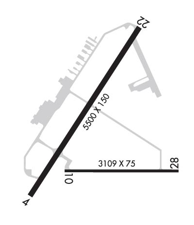
Airport Diagram might not be current.

Facility Name: DELAWARE COASTAL
City Name: GEORGETOWN
County: SUSSEX
State abbrev: DE
State Name: DELAWARE
   
Ownership: PUBLICLY OWNED
Use: OPEN TO THE PUBLIC
Owner's Name: SUSSEX COUNTY COUNCIL
Address: PO BOX 589
 GEORGETOWN, DE 19947
Owner's Phone: 302-855-7770
  
Manager's Name: ROBERT L. BRYANT; ROBERT.BRYANT@SUSSEXCOUNTYDE.GOV.
Address: 21553 RUDDER LANE
 GEORGETOWN, DE 19947
Phone: 302-855-7774
   
FAA Region: EASTERN
FAA Field Office: HAR
Joseph Pelton - www.aviationonlinetraining.net


Click here for full scale & interactive Sectional view of KGED


Sunrise / Sunset times for DELAWARE COASTAL

DateSunriseSunset
04/22/24 Monday6:1419:46
04/23/24 Tuesday6:1319:47
04/24/24 Wednesday6:1219:48
04/25/24 Thursday6:1119:49
04/26/24 Friday6:0919:50
04/27/24 Saturday6:0819:51
04/28/24 Sunday6:0719:51
04/29/24 Monday6:0619:52
04/30/24 Tuesday6:0419:53
05/01/24 Wednesday6:0319:54
05/02/24 Thursday6:0219:55
05/03/24 Friday6:0119:56
05/04/24 Saturday6:0019:57
05/05/24 Sunday5:5919:58

Airport Facilities

Airport Attendance Schedule7 Days A Week 0800-1800; ARPT UNATNDD THANKSGIVING DAY AND CHRISTMAS DAY.
Airport Status OPERATIONAL (This Status can change at any time - please check NOTAMS)
Airport Lighting ScheduleACTVT MALS RWY 4; REIL RWY 04, 22, 10, 28; MIRL RWY 04/22 & 10/28 - CTAF.
Airport Storage AvailableTie Downs
Extra Services AvailableAir Ambulance, Charter, Flight Instruction, Aircraft Rental, Aircraft Sales
Wind IndicatorYES - (lighted)
Control TowerNO
CTAF Frequency123.000
Unicom Frequency123.000
Rotating Beacon ColorWG
Segmented CircleYES
Landing FeeNO

Airport Inspection Data

Airport InspectedSTATE - performed by STATE AERONAUTICAL PERSONNEL
Inspection Date06/14/2023

Airport Services

Type of Fuel AvailableGrade 100LL, JET A (freeze point -40C)
Airframe Repair ServiceMAJOR
Power Plant Repair ServiceMAJOR

Geographic Data

LatitudeN3841.3
LongitudeW07521.6 (ESTIMATED)
Arpt Elevation53ft (SURVEYED)
Magnetic Variation12W
2 miles SEof GEORGETOWN
Traffic Pattern Altitude
Sectional ChartWASHINGTON

Aircraft Data

Operations (Reported)YearlyAvg. Daily
General Aviation Transient 690019
General Aviation Local 2540070
Air Taxi 5001
Commerical 00
Commuter 00
Military 1000
Aircraft based on Field
General Aviation Singles 49
General Aviation Multi 6
Jet Aircraft 3
General Aviation Helicopters 6
Military Aircraft 0
Gliders 0
Ultralights 0

FAA Services

FSS on field NO
FSS tie-in MILLVILLE
FSS Phone 1-800-WX-BRIEF
Who issues Notams GED
Notam D service at airport YES
ARTCC Name WASHINGTON

Federal Status

Airport Certification
Aircraft Rescue & Firefighting IndexNone
Airport of EntryNo
Custom Landing RightsYES
Joint Civil/MilitaryNo
Military Landing rightsYES

Federal Agreements

NATIONAL PLAN OF INTEGRATED AIRPORT SYSTEMS (NPIAS)
GRANT AGREEMENTS UNDER FAAP/ADAP/AIP
SURPLUS PROPERTY AGREEMENT UNDER REGULATION 16-WAA
ASSURANCES PURSUANT TO TITLE VI, CIVIL RIGHTS ACT OF 1964
AGREEMENT UNDER DLAND OR DCLA HAS EXPIRED.

Remarks

PAEW WITHIN SAFETY AREA OF RWYS & TWYS.
BIRDS, DEER, AND OTHER WILDLIFE INVOF RWYS.
FOR CD IF UNA VIA GCO FREQ, CTC DOVER APCH AT 302-677-3940. IF DOVER APCH UNA, CTC WASHINGTON ARTCC AT 703-771-3587.
FBO HRS 0800-1600 LST. FOR SVC/FUEL AFT HRS CALL 302-855-2355
GCO AVBL ON FREQ 125.55.
Airport Communications & Frequencies:
CTAF Frequency:
123.000
Unicom Frequency:
123.000
DOVER Primary Approach Frequencies:  
132.425
257.875
DOVER Primary Departure Frequencies:  
132.425
257.875
Runway Identifications
Runway Identification: 04/22
Length: 5500 ft
Width: 150 ft
Surface: ASPHALT-GOOD CONDITION
Edge lights: Medium Intensity

Treatment: GROOVED
Weight: PCN 43 /F/A/X/T

 Runway: 04   Runway: 22
Mag heading: 45°Mag heading: 225°
Rwy Slope: -.01% DownRwy Slope: .01% Up
Approach: Approach:
Pattern: Left TrafficPattern: Left Traffic
Markings: NONPRECISION INSTRUMENTMarkings: NONPRECISION INSTRUMENT
Marking Condition: GOODMarking Condition: GOOD
Arresting Dev: Arresting Dev:
Lat & Long: N3841.0  W07521.9Lat. & Long.: N3841.7  W07521.3
Elev: 48.9 ft. MSLElev: 48.5 ft. MSL
TCH: 45 ft. AGLTCH: 45 ft. AGL
Visual Glide Path: 3.00 degreesVisual Glide Path: 3.00 degrees
Displaced Threshold: 370 feetDisplaced Threshold: 169 feet
Touchdown Zone: YESTouchdown Zone: YES
Touchdown Elev.: 50.7 feetTouchdown Elev.: 50.7 feet
Visual Glide Slope: 4-Light PAPI on LEFT side of RunwayVisual Glide Slope: 4-Light PAPI on LEFT side of Runway
RVR Equipment: RVR Equipment:
RVV Equipment: NORVV Equipment: NO
Approach Lights: MALS - 1,400 foot medium intensity approach lighting systemApproach Lights:
REIL: YESREIL: YES
Centerline Lights: NOCenterline Lights: NO
Touchdown lights: NOTouchdown lights: NO
Runway Category: Runway with a Non-precision Approach having visibility minimums greater than 3/4 mileRunway Category: Runway with a Non-precision Approach having visibility minimums greater than 3/4 mile
Declared Distances: Declared Distances:
Obstructions: TREESObstructions:
Marked: NOT Marked/LightedMarked:
Clearance slope: 21:1Clearance slope: 34:1
Obstruction height: 49 feet AGLObstruction height:
Dist. from runway: 1258 feetDist. from runway:
Centerline offset: 140 left of centerlineCenterline offset:
Comments: Comments:
Runway Identification: 10/28
Length: 3109 ft
Width: 75 ft
Surface: ASPHALT-GOOD CONDITION
Edge lights: Medium Intensity

Treatment: NONE
Weight: PCN 36 /F/A/X/T

 Runway: 10   Runway: 28
Mag heading: 102°Mag heading: 282°
Rwy Slope: .14% UpRwy Slope: -.14% Down
Approach: Approach:
Pattern: Left TrafficPattern: Left Traffic
Markings: BASICMarkings: BASIC
Marking Condition: GOODMarking Condition: GOOD
Arresting Dev: Arresting Dev:
Lat & Long: N3841.1  W07521.7Lat. & Long.: N3841.1  W07521.1
Elev: 49.0 ft. MSLElev: 53.3 ft. MSL
TCH: 46 ft. AGLTCH: 40 ft. AGL
Visual Glide Path: 3.50 degreesVisual Glide Path: 3.00 degrees
Displaced Threshold: NoDisplaced Threshold: No
Touchdown Zone: YESTouchdown Zone: YES
Touchdown Elev.: 53.2 feetTouchdown Elev.: 53.3 feet
Visual Glide Slope: 2-Light PAPI on LEFT side of RunwayVisual Glide Slope: 2-Light PAPI on LEFT side of Runway
RVR Equipment: RVR Equipment:
RVV Equipment: NORVV Equipment: NO
Approach Lights: Approach Lights:
REIL: YESREIL: YES
Centerline Lights: NOCenterline Lights: NO
Touchdown lights: NOTouchdown lights: NO
Runway Category: Runway with a Visual ApproachRunway Category: Runway with a Visual Approach
Declared Distances: Declared Distances:
C:22/P: