Click here for more info on on SMS!

KGDV

DAWSON COMMUNITY
GLENDIVE
MT
Time Zone: Mountain
Lat: N 4708.3
Long: W 10448.4
Elev: 2458
Var: -10
Longest Runway: 5704
AWOS: 135.07
CTAF: 122.8

FBO & Flight Services info for KGDV

FBOs: Update your Fuel Prices
Our terminal building is open all day and night with overnight sleeping room for transient travelers. Self-service fuel is available 24 hours a day. Call FBO for more information or assistance.
Ph: 406-687-3372 Fax: 406-687-3563 Freq: 122.8WebsiteE-Mail
Service
Jet
100LL
SAF
MoGas
Fuel Avail: PRIST PREMIXED
Full        Last Update: 04/05/2024 21:30

Self5.606.10    
Misc. Info: Address: 207 WEST BELL   GLENDIVE, MT 59330

AWOSPh: 406-687-3346
-
Freq: 135.07  
If you are an FBO, call 1-203-262-1700 to update your info or email: FltPlan.Advertising@garmin.com
Advertise your FBO on FltPlan.com

Runway & Approach Info for KGDV
Rwy
Length
Land Dist**
Approach*
  Rwy
Length
Land Dist**
Approach*
02
3002x60  3002'          
 
  
20
  3002x60  3002'          
 
12
5704x100  5704'          
 
  
30
  5704x100  5704'          
 
 * only ILS, LOC, LDA, and SDF approaches to a specific runway are shown
** For any Declared Landing Distance Available, please see A/FD or Approach plates
Runway Weight Capability (lbs.) Help
Runway IDSingle WheelDouble WheelDouble Tandem WheelDual Double Wheel
02/20N/AN/AN/AN/A
12/3038,00050,000N/AN/A
These numbers are Advisory and are not limits.   The Airport Manager should have more accurate Weight Limits
Approach Charts
Approaches    
Current Weather/Notams
Customs Information Send updates to Support@FltPlan.com
Customs Not Available
Database effective 05/16/2024
Airport Diagram of KGDV
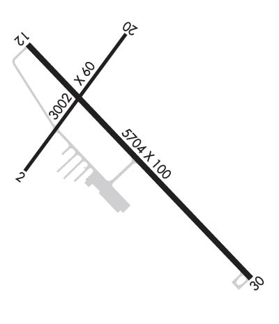
Airport Diagram might not be current.

Facility Name: DAWSON COMMUNITY
City Name: GLENDIVE
County: DAWSON
State abbrev: MT
State Name: MONTANA
   
Ownership: PUBLICLY OWNED
Use: OPEN TO THE PUBLIC
Owner's Name: DAWSON COUNTY
Address: 207 WEST BELL
 GLENDIVE, MT 59330
Owner's Phone: (406) 377-3058
  
Manager's Name: CRAIG HOSTETLER
Address: 207 WEST BELL
 GLENDIVE, MT 59330
Phone: 406-989-2054; AFTER HRS CONTACT AMGR 406-989-2054.
   
FAA Region: NORTHWEST MOUNTAIN
FAA Field Office: HLN


Sunrise / Sunset times for DAWSON COMMUNITY

DateSunriseSunset
04/23/24 Tuesday5:5520:00
04/24/24 Wednesday5:5420:02
04/25/24 Thursday5:5220:03
04/26/24 Friday5:5020:04
04/27/24 Saturday5:4820:06
04/28/24 Sunday5:4720:07
04/29/24 Monday5:4520:09
04/30/24 Tuesday5:4420:10
05/01/24 Wednesday5:4220:11
05/02/24 Thursday5:4020:13
05/03/24 Friday5:3920:14
05/04/24 Saturday5:3720:15
05/05/24 Sunday5:3620:17
05/06/24 Monday5:3420:18

Airport Facilities

Airport Attendance Schedule7 Days A Week 0730-1830
Airport Status OPERATIONAL (This Status can change at any time - please check NOTAMS)
Airport Lighting ScheduleACTIVATE MIRL RWY 02-20 AND RWY 12-30, PAPI RWY 02 AND RWY 20, REIL RWY 12 AND RWY 30 - CTAF. VASI RY 12/30 OPER CONTINUOUSLY.
Airport Storage AvailableTie Downs, Hanger
Extra Services AvailableCrop Dusting
Wind IndicatorYES - (lighted)
Control TowerNO
CTAF Frequency122.800
Unicom Frequency122.800
Rotating Beacon ColorWG
Segmented CircleYES
Landing FeeNO

Airport Inspection Data

Airport InspectedSTATE - performed by STATE AERONAUTICAL PERSONNEL
Inspection Date10/13/2022

Airport Services

Type of Fuel AvailableGrade 100LL, JET A
Airframe Repair ServiceMINOR
Power Plant Repair ServiceMINOR

Geographic Data

LatitudeN4708.3
LongitudeW10448.4 (ESTIMATED)
Arpt Elevation2458ft (SURVEYED)
Magnetic Variation10E
4 miles NWof GLENDIVE
Traffic Pattern Altitude
Sectional ChartBILLINGS

Aircraft Data

Operations (Reported)YearlyAvg. Daily
General Aviation Transient 12003
General Aviation Local 16004
Air Taxi 30608
Commerical 00
Commuter 00
Military 200
Aircraft based on Field
General Aviation Singles 20
General Aviation Multi 0
Jet Aircraft 0
General Aviation Helicopters 0
Military Aircraft 0
Gliders 0
Ultralights 0

FAA Services

FSS on field NO
FSS tie-in GREAT FALLS
FSS Phone 1-800-WX-BRIEF
Who issues Notams GDV
Notam D service at airport YES
ARTCC Name SALT LAKE CITY

Federal Status

Airport Certification
Aircraft Rescue & Firefighting IndexNone
Airport of EntryNo
Custom Landing RightsNo
Joint Civil/MilitaryNo
Military Landing rightsYES

Federal Agreements

NATIONAL PLAN OF INTEGRATED AIRPORT SYSTEMS (NPIAS)
GRANT AGREEMENTS UNDER FAAP/ADAP/AIP
ASSURANCES PURSUANT TO TITLE VI, CIVIL RIGHTS ACT OF 1964

Remarks

AIRFIELD SURFACE CONDITIONS UNMONITORED 0100-1100 NOV-MAY.
FOR CD IF UNA TO CTC ON FSS FREQ, CTC SALT LAKE ARTCC AT 801-320-2568.
RWY 02/2 0 TWY A HAS EDGE LIPS EXCEEDING 3 IN.
Airport Communications & Frequencies:
CTAF Frequency:
122.800
Unicom Frequency:
122.800
Remarks
  • APCH/DEP CTL SVC PRVDD BY SALT LAKE ARTCC (ZLC) ON 126.85/305.2 (WATFORD CITY RCAG).
  • Runway Identifications
    Runway Identification: 02/20
    Length: 3002 ft
    Width: 60 ft
    Surface: ASPHALT-GOOD CONDITION
    Edge lights: Medium Intensity

    Treatment: NONE

     Runway: 02   Runway: 20
    Mag heading: 26°Mag heading: 206°
    Rwy Slope: -.08% DownRwy Slope: .08% Up
    Approach: Approach:
    Pattern: Left TrafficPattern: Left Traffic
    Markings: BASICMarkings: BASIC
    Marking Condition: GOODMarking Condition: GOOD
    Arresting Dev: Arresting Dev:
    Lat & Long: N4708.2  W10448.8Lat. & Long.: N4708.6  W10448.4
    Elev: 2456.1 ft. MSLElev: 2453.8 ft. MSL
    TCH: 26 ft. AGLTCH: 24 ft. AGL
    Visual Glide Path: 3.00 degreesVisual Glide Path: 3.00 degrees
    Displaced Threshold: NoDisplaced Threshold: No
    Touchdown Zone: YESTouchdown Zone: YES
    Touchdown Elev.: 2458.0 feetTouchdown Elev.: 2458.0 feet
    Visual Glide Slope: 2-Light PAPI on LEFT side of RunwayVisual Glide Slope: 2-Light PAPI on LEFT side of Runway
    RVR Equipment: RVR Equipment:
    RVV Equipment: NORVV Equipment: NO
    Approach Lights: Approach Lights:
    REIL: NOREIL: NO
    Centerline Lights: NOCenterline Lights: NO
    Touchdown lights: NOTouchdown lights: NO
    Runway Category: Runway with a Visual ApproachRunway Category: Runway with a Visual Approach
    Declared Distances: TORA:3002' TODA:3002' ASDA:3002' LDA:3002'Declared Distances: TORA:3002' TODA:3002' ASDA:3002' LDA:3002'
    Runway Identification: 12/30
    Length: 5704 ft
    Width: 100 ft
    Surface: ASPHALT-GOOD CONDITION
    Edge lights: Medium Intensity

    Treatment: GROOVED

     Runway: 12   Runway: 30
    Mag heading: 126°Mag heading: 306°
    Rwy Slope: -.07% DownRwy Slope: .07% Up
    Approach: Approach:
    Pattern: Left TrafficPattern: Left Traffic
    Markings: NONPRECISION INSTRUMENTMarkings: NONPRECISION INSTRUMENT
    Marking Condition: GOODMarking Condition: GOOD
    Arresting Dev: Arresting Dev:
    Lat & Long: N4708.6  W10448.8Lat. & Long.: N4707.9  W10447.9
    Elev: 2458.3 ft. MSLElev: 2454.2 ft. MSL
    TCH: 37 ft. AGLTCH: 37 ft. AGL
    Visual Glide Path: 3.00 degreesVisual Glide Path: 3.00 degrees
    Displaced Threshold: NoDisplaced Threshold: No
    Touchdown Zone: YESTouchdown Zone: YES
    Touchdown Elev.: 2458.3 feetTouchdown Elev.: 2456.0 feet
    Visual Glide Slope: 4-BOX VASI ON LEFT SIDE OF RUNWAYVisual Glide Slope: 4-BOX VASI ON LEFT SIDE OF RUNWAY
    RVR Equipment: RVR Equipment:
    RVV Equipment: NORVV Equipment: NO
    Approach Lights: Approach Lights:
    REIL: YESREIL: YES
    Centerline Lights: NOCenterline Lights: NO
    Touchdown lights: NOTouchdown lights: NO
    Runway Category: Runway with a Non-precision Approach having visibility minimums greater than 3/4 mileRunway Category: Runway with a Non-precision Approach having visibility minimums greater than 3/4 mile
    Declared Distances: TORA:5704' TODA:5704' ASDA:5704' LDA:5704'Declared Distances: TORA:5704' TODA:5704' ASDA:5704' LDA:5704'
    C:6/P: