KGCK

GARDEN CITY RGNL
GARDEN CITY
KS
Time Zone: Central
Lat: N 3755.7
Long: W 10043.5
Elev: 2891
Var: -05
Longest Runway: 7299
AWOS: 121.32
Ground: 119.0
Tower: 118.15

FBO & Flight Services info for KGCK

FBOs: Update your Fuel Prices

CROSBY FLYINGPh: 800-539-5055 Fax: 620-275-5629 Freq: 122.95
Service
Jet
100LL
SAF
MoGas
Fuel Avail: PRIST PREMIXED
Full5.496.50    Last Update: 03/26/2024 12:41

Self        
 Address: 2117 S. AIR SERVICE RD,   GARDEN CITY, KS 67846
ASOSPh: 620-275-0803
-
Freq: 121.32  
If you are an FBO, call 1-203-262-1700 to update your info or email: FltPlan.Advertising@garmin.com
Advertise your FBO on FltPlan.com
FBOs at nearby airports who want your business:
KPNC

Ponca City Oklahoma is conveniently located in the center of the United States just 57 nm south of Wichita Kansas, offering you the best discount fuel stop in the country with a 7200' by 150' runway and the quickest turn around.
Ph: 580-767-0429 WebsiteFax: 580-763-4575 Freq: 123.0

Runway & Approach Info for KGCK
Rwy
Length
Land Dist**
Approach*
  Rwy
Length
Land Dist**
Approach*
12
5700x100  5700'          
 
  
30
  5700x100  5700'          
 
17
7299x100  7299'          
 
  
35
  7299x100  7299'          
ILS
 109.90 - 355°  
 * only ILS, LOC, LDA, and SDF approaches to a specific runway are shown
** For any Declared Landing Distance Available, please see A/FD or Approach plates
Runway Weight Capability (lbs.) Help
Runway IDSingle WheelDouble WheelDouble Tandem WheelDual Double Wheel
12/3048,00060,000N/AN/A
17/3576,00091,000125,000N/A
These numbers are Advisory and are not limits.   The Airport Manager should have more accurate Weight Limits
Approach Charts
Approaches    
Current Weather/Notams
Customs Information Send updates to Support@FltPlan.com
Customs Not Available
Database effective 04/18/2024
Airport Diagram of KGCK
Airport Diagram might not be current.

Facility Name: GARDEN CITY RGNL
City Name: GARDEN CITY
County: FINNEY
State abbrev: KS
State Name: KANSAS
   
Ownership: PUBLICLY OWNED
Use: OPEN TO THE PUBLIC
Owner's Name: CITY OF GARDEN CITY
Address: CITY HALL, BOX 499
 GARDEN CITY, KS 67846
Owner's Phone: 620-276-1190
  
Manager's Name: MS. RACHELLE POWELL
Address: 2225 S. AIR SERVICE RD. 112; EMAIL: RACHELLE.POWELL@GARDENCITYKS.US
 GARDEN CITY, KS 67846
Phone: 620-276-1190; FAX 620-276-1192
   
FAA Region: CENTRAL
FAA Field Office: NONE


Sunrise / Sunset times for GARDEN CITY RGNL

DateSunriseSunset
04/18/24 Thursday7:0220:22
04/19/24 Friday7:0120:23
04/20/24 Saturday7:0020:24
04/21/24 Sunday6:5820:25
04/22/24 Monday6:5720:26
04/23/24 Tuesday6:5620:27
04/24/24 Wednesday6:5420:28
04/25/24 Thursday6:5320:29
04/26/24 Friday6:5220:30
04/27/24 Saturday6:5120:31
04/28/24 Sunday6:4920:32
04/29/24 Monday6:4820:33
04/30/24 Tuesday6:4720:33
05/01/24 Wednesday6:4620:34

Airport Facilities

Airport Attendance Schedule7 Days A Week 0700-2100; FOR SVC AFTER HRS CALL 620-275-5055.
Airport Status OPERATIONAL (This Status can change at any time - please check NOTAMS)
Airport Lighting ScheduleACTVT MIRL RY 12/30 & HIRL RY 17/35; REIL RYS 17; 12; 30 & MALSR RY 35 - CTAF. PAPI RYS 12 & 30 AND VASI RYS 17 & 35 ON 24 HRS.
Airport Storage AvailableTie Downs, Hanger
Extra Services AvailableCrop Dusting, Charter, Flight Instruction, Aircraft Rental, Aircraft Sales
Wind IndicatorYES - (lighted)
Control TowerYES
CTAF Frequency118.150
Unicom Frequency122.950
Rotating Beacon ColorWG
Segmented CircleNO
Landing FeeNO

Airport Inspection Data

Airport InspectedFEDERAL - performed by FAA AIRPORTS FIELD PERSONNEL
Inspection Date08/02/2023

Airport Services

Type of Fuel AvailableGrade 100LL, JET A (freeze point -40C); -10FOR MILITARY FUEL CALL 620-275-5055.
Airframe Repair ServiceMAJOR
Power Plant Repair ServiceMAJOR

Geographic Data

LatitudeN3755.7
LongitudeW10043.5 (ESTIMATED)
Arpt Elevation2890ft (SURVEYED)
Magnetic Variation05E
8 miles SEof GARDEN CITY
Traffic Pattern Altitude
Sectional ChartWICHITA

Aircraft Data

Operations (Reported)YearlyAvg. Daily
General Aviation Transient 880524
General Aviation Local 17165
Air Taxi 27498
Commerical 4821
Commuter 00
Military 14804
Aircraft based on Field
General Aviation Singles 58
General Aviation Multi 7
Jet Aircraft 4
General Aviation Helicopters 1
Military Aircraft 0
Gliders 0
Ultralights 0

FAA Services

FSS on field NO
FSS tie-in WICHITA
FSS Phone 1-800-WX-BRIEF
Who issues Notams GCK
Notam D service at airport YES
ARTCC Name KANSAS CITY

Federal Status

Airport CertificationAIRPORT RECEIVING SCHEDULED AIR CARRIER SERVICE FROM CARRIERS CERTIFICATED BY THE CIVIL AERONAUTICS BOARD; CLSD TO UNSKED ACR OPNS WITH MORE THAN 30 PSGR SEATS EXCP PPR 48 HRS CALL AMGR (620) 276-1190/(620) 290-3810. ARFF INDEX B PROVIDED.
Aircraft Rescue & Firefighting IndexAIRPORT HAS A CERTIFICATE UNDER CFR PART 139
Airport of EntryNo
Custom Landing RightsNo
Joint Civil/MilitaryNo
Military Landing rightsYES

Federal Agreements

NATIONAL PLAN OF INTEGRATED AIRPORT SYSTEMS (NPIAS)
GRANT AGREEMENTS UNDER FAAP/ADAP/AIP
SURPLUS PROPERTY AGREEMENT UNDER PUBLIC LAW 289
ASSURANCES PURSUANT TO TITLE VI, CIVIL RIGHTS ACT OF 1964

Remarks

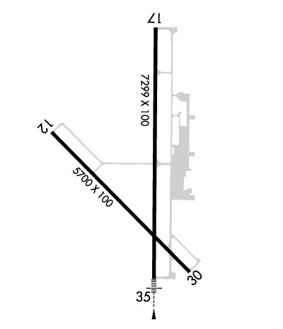
RY 35 DESIGNATED THE CALM WIND RY.
AIR CARRIER OPS ARE NOT AUTHORIZED IN EXCESS OF 15 MINUTES BEFORE OR AFTER SCHEDULED ARRIVAL/DEPARTURE TIMES WITHOUT PRIOR COORDINATION WITH AMGR AND CONFIRMATION THAT ARFF IS AVBL PRIOR TO LDNG OR TKOF.
IN THE EVENT OF AN AIR CARRIER DIVERSION OR OTHER IRREGULAR OPERATIONS EVENTS, AIRCRAFT OPERATORS SHOULD CONTACT AMGR 620-290-3810. FACILITY CONSTRAINTS INCLUDE: LACK OF INTERNATIONAL PASSENGER PROCESSING FACILITIES, LIMITED NUMBER OF PARKING POSITIONS AND LIMITED TERMINAL SPACE FOR PASSENGERS.
ATCT BLIND SPOT ON THE NORTH TWY A HOLD BAY.
FOR CD IF UNA TO CTC ON FSS FREQ, CTC KANSAS CITY ARTCC AT 913-254-8508.
Airport Communications & Frequencies:
GARDEN CITY Tower Frequencies:   Hours(local) of operation: 0700-2100   
118.15
254.4
GARDEN CITY Ground Frequencies:
119.0
254.4
CTAF Frequency:
118.150
Unicom Frequency:
122.950
Remarks
  • APCH/DEP CTL SVC PRVDD BY KANSAS CITY ARTCC (ZKC) ON FREQS 125.2/285.425 (GARDEN CITY RCAG).
  • ATCT OPERATED BY MIDWEST.
  • Runway Identifications
    Runway Identification: 12/30
    Length: 5700 ft
    Width: 100 ft
    Surface: CONCRETE-GOOD CONDITION
    Edge lights: Medium Intensity

    Treatment: NONE
    Weight: PCN 35 /R/C/W/T

     Runway: 12   Runway: 30
    Mag heading: 130°Mag heading: 310°
    Rwy Slope: -.23% DownRwy Slope: .23% Up
    Approach: Approach:
    Pattern: Left TrafficPattern: Left Traffic
    Markings: NONPRECISION INSTRUMENTMarkings: NONPRECISION INSTRUMENT
    Marking Condition: GOODMarking Condition: GOOD
    Arresting Dev: Arresting Dev:
    Lat & Long: N3755.9  W10044.0Lat. & Long.: N3755.2  W10043.2
    Elev: 2890.7 ft. MSLElev: 2877.4 ft. MSL
    TCH: 47 ft. AGLTCH: 46 ft. AGL
    Visual Glide Path: 3.00 degreesVisual Glide Path: 3.00 degrees
    Displaced Threshold: NoDisplaced Threshold: No
    Touchdown Zone: YESTouchdown Zone: YES
    Touchdown Elev.: 2890.8 feetTouchdown Elev.: 2885.4 feet
    Visual Glide Slope: 2-Light PAPI on LEFT side of RunwayVisual Glide Slope: 2-Light PAPI on LEFT side of Runway
    RVR Equipment: RVR Equipment:
    RVV Equipment: NORVV Equipment: NO
    Approach Lights: Approach Lights:
    REIL: YESREIL: YES
    Centerline Lights: NOCenterline Lights: NO
    Touchdown lights: NOTouchdown lights: NO
    Runway Category: Runway with a Non-precision Approach having visibility minimums greater than 3/4 mileRunway Category: Runway with a Non-precision Approach having visibility minimums greater than 3/4 mile
    Declared Distances: TORA:5700' TODA:5700' ASDA:5700' LDA:5700'Declared Distances: TORA:5700' TODA:5700' ASDA:5700' LDA:5700'
    Runway Identification: 17/35
    Length: 7299 ft
    Width: 100 ft
    Surface: CONCRETE-GOOD CONDITION
    Edge lights: High Intensity

    Treatment: GROOVED
    Weight: PCN 38 /R/C/W/T

     Runway: 17   Runway: 35
    Mag heading: 175°Mag heading: 355°
    Rwy Slope: -.16% DownRwy Slope: .16% Up
    Approach: Approach: ILS
    Pattern: Left TrafficPattern: Left Traffic
    Markings: NONPRECISION INSTRUMENTMarkings: PRECISION INSTRUMENT
    Marking Condition: GOODMarking Condition: GOOD
    Arresting Dev: Arresting Dev:
    Lat & Long: N3756.4  W10043.4Lat. & Long.: N3755.2  W10043.4
    Elev: 2888.6 ft. MSLElev: 2876.6 ft. MSL
    TCH: 39 ft. AGLTCH: 41 ft. AGL
    Visual Glide Path: 3.00 degreesVisual Glide Path: 3.00 degrees
    Displaced Threshold: NoDisplaced Threshold: No
    Touchdown Zone: YESTouchdown Zone: YES
    Touchdown Elev.: 2888.7 feetTouchdown Elev.: 2885.4 feet
    Visual Glide Slope: 4-BOX VASI ON LEFT SIDE OF RUNWAYVisual Glide Slope: 4-BOX VASI ON LEFT SIDE OF RUNWAY
    RVR Equipment: RVR Equipment:
    RVV Equipment: NORVV Equipment: NO
    Approach Lights: Approach Lights: MALSR - 1,400 foot medium intensity approach lighting system with runway alignment indicator lights
    REIL: YESREIL: NO
    Centerline Lights: NOCenterline Lights: NO
    Touchdown lights: NOTouchdown lights: NO
    Runway Category: Runway with a Non-precision Approach having visibility minimums greater than 3/4 mileRunway Category: Precision Instrument Runway
    Declared Distances: TORA:7299' TODA:7299' ASDA:7299' LDA:7299'Declared Distances: TORA:7299' TODA:7299' ASDA:7299' LDA:7299'
    C:47/P: