Current Weather/Notams (Metars, TAFs, Notams, NWS Forecast, PIREPS, and nearby weather)
Customs Information Send updates to Support@FltPlan.com
Customs Not Available
Database effective 04/18/2024
Airport Diagram might not be current.
|
| Facility Name: | GRANT COUNTY RGNL/OGILVIE FLD |
| City Name: | JOHN DAY |
| County: | GRANT |
| State abbrev: | OR |
| State Name: | OREGON |
| | |
| Ownership: | PUBLICLY OWNED |
| Use: | OPEN TO THE PUBLIC |
| Owner's Name: | GRANT COUNTY REGIONAL AIRPORT |
| Address: | , 201 S. HUMBOLT, STE. 280 |
| | CANYON CITY, OR 97820 |
| Owner's Phone: | 541-575-0059 |
| | |
| Manager's Name: | HALEY WALKER |
| Address: | 72000 AIRPORT ROAD |
| | JOHN DAY, OR 97845 |
| Phone: | 541-575-1151 |
| | |
| FAA Region: | NORTHWEST MOUNTAIN |
| FAA Field Office: | SEA |
Runway Identifications
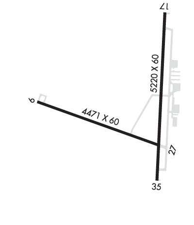
Runway Identification: 09/27Length: 4100 ft
Width: 60 ft
Surface: ASPHALT-GOOD CONDITION
Edge lights: Medium IntensityTreatment: NONE
| | Runway: 09 | | Runway: 27 |
| Mag heading: | 93° | Mag heading: | 273° |
| Rwy Slope: | 1.03% Up | Rwy Slope: | -1.03% Down |
| Approach: | | Approach: | |
| Pattern: | Left Traffic | Pattern: | Right Traffic |
| Markings: | NONPRECISION INSTRUMENT | Markings: | BASIC |
| Marking Condition: | GOOD | Marking Condition: | GOOD |
| Arresting Dev: | | Arresting Dev: | |
| Lat & Long: | N4424.2 W11858.8 | Lat. & Long.: | N4424.0 W11857.9 |
| Elev: | 3646.8 ft. MSL | Elev: | 3688.9 ft. MSL |
| TCH: | 45 ft. AGL | TCH: | |
| Visual Glide Path: | 3.00 degrees | Visual Glide Path: | |
| Displaced Threshold: | No | Displaced Threshold: | No |
| Touchdown Zone: | YES | Touchdown Zone: | YES |
| Touchdown Elev.: | 3671.4 feet | Touchdown Elev.: | 3688.9 feet |
| Visual Glide Slope: | 4-Light PAPI on LEFT side of Runway | Visual Glide Slope: | |
| RVR Equipment: | | RVR Equipment: | |
| RVV Equipment: | NO | RVV Equipment: | NO |
| Approach Lights: | | Approach Lights: | |
| REIL: | YES | REIL: | NO |
| Centerline Lights: | NO | Centerline Lights: | NO |
| Touchdown lights: | NO | Touchdown lights: | NO |
| Runway Category: | Runway with a Non-precision Approach | Runway Category: | Runway with a Visual Approach |
| Declared Distances: | | Declared Distances: | |
| Obstructions: | FENCE | Obstructions: | |
| Marked: | NOT Marked/Lighted | Marked: | |
| Clearance slope: | 13:1 | Clearance slope: | 50:1 |
| Obstruction height: | 10 feet AGL | Obstruction height: | |
| Dist. from runway: | 333 feet | Dist. from runway: | |
| Centerline offset: | | Centerline offset: | |
| Comments: | | Comments: | |
Runway Identification: 17/35Length: 5224 ft
Width: 60 ft
Surface: ASPHALT-GOOD CONDITION
Edge lights: Medium IntensityTreatment: NONE
| | Runway: 17 | | Runway: 35 |
| Mag heading: | 167° | Mag heading: | 347° |
| Rwy Slope: | .53% Up | Rwy Slope: | -.53% Down |
| Approach: | | Approach: | |
| Pattern: | Left Traffic | Pattern: | Left Traffic |
| Markings: | BASIC | Markings: | BASIC |
| Marking Condition: | FAIR; RYS 17/35 BSC MARKINGS, PLUS AIMING POINT MARKS. | Marking Condition: | FAIR |
| Arresting Dev: | | Arresting Dev: | |
| Lat & Long: | N4424.7 W11857.8 | Lat. & Long.: | N4423.8 W11857.9 |
| Elev: | 3675.0 ft. MSL | Elev: | 3702.5 ft. MSL |
| TCH: | 52 ft. AGL | TCH: | |
| Visual Glide Path: | 4.00 degrees | Visual Glide Path: | |
| Displaced Threshold: | No | Displaced Threshold: | No |
| Touchdown Zone: | YES | Touchdown Zone: | YES |
| Touchdown Elev.: | 3690.4 feet | Touchdown Elev.: | 3702.5 feet |
| Visual Glide Slope: | 4-Light PAPI on LEFT side of Runway | Visual Glide Slope: | |
| RVR Equipment: | | RVR Equipment: | |
| RVV Equipment: | NO | RVV Equipment: | NO |
| Approach Lights: | | Approach Lights: | |
| REIL: | YES | REIL: | NO |
| Centerline Lights: | NO | Centerline Lights: | NO |
| Touchdown lights: | NO | Touchdown lights: | NO |
| Runway Category: | Runway with a Visual Approach | Runway Category: | Runway with a Visual Approach |
| Declared Distances: | | Declared Distances: | |
| Obstructions: | | Obstructions: | Unknown |
| Marked: | | Marked: | NOT Marked/Lighted |
| Clearance slope: | 50:1 | Clearance slope: | 50:1 |
| Obstruction height: | | Obstruction height: | +850FT TERRAIN 9400 FT SOUTH. |
| Dist. from runway: | | Dist. from runway: | |
| Centerline offset: | | Centerline offset: | |
| Comments: | | Comments: | |

