Click here for more info on on SMS!

KGCC

GILLETTE-CAMPBELL COUNTY
GILLETTE
WY
Time Zone: Mountain
Lat: N 4420.9
Long: W 10532.4
Elev: 4365
Var: -09
Longest Runway: 7501
AWOS: 124.17
CTAF: 118.50

FBO & Flight Services info for KGCC

FBOs: Update your Fuel Prices

GATE ONEPh: 307-682-1859
-
-
Service
Jet
100LL
SAF
MoGas
Fuel Avail: PRIST+$0.15/gal
Full6.295.78    Caution: Fuel prices have not been updated in 54 days.
Last Update: 03/02/2024 15:49

Self  5.28    
 Address: 2000 AIRPORT RD., SUITE 160   GILLETTE, WY 82716
ASOSPh: 307-682-1745
-
Freq: 124.17  
If you are an FBO, call 1-203-262-1700 to update your info or email: FltPlan.Advertising@garmin.com
Advertise your FBO on FltPlan.com

Runway & Approach Info for KGCC
Rwy
Length
Land Dist**
Approach*
  Rwy
Length
Land Dist**
Approach*
03
5804x75  5804'          
 
  
21
  5804x75  5804'          
 
16
7501x150  7501'          
 
  
34
  7501x150  7501'          
ILS/DME
 110.10 - 340°  
 * only ILS, LOC, LDA, and SDF approaches to a specific runway are shown
** For any Declared Landing Distance Available, please see A/FD or Approach plates
Runway Weight Capability (lbs.) Help
Runway IDSingle WheelDouble WheelDouble Tandem WheelDual Double Wheel
03/2140,00060,000N/AN/A
16/3470,000110,000160,000N/A
These numbers are Advisory and are not limits.   The Airport Manager should have more accurate Weight Limits
Approach Charts
Approaches    
Current Weather/Notams
Customs Information Send updates to Support@FltPlan.com
Customs Not Available
Database effective 05/16/2024
Airport Diagram of KGCC
Airport Diagram might not be current.

Facility Name: NORTHEAST WYOMING RGNL
City Name: GILLETTE
County: CAMPBELL
State abbrev: WY
State Name: WYOMING
   
Ownership: PUBLICLY OWNED
Use: OPEN TO THE PUBLIC
Owner's Name: CAMPBELL CO
Address: 2000 AIRPORT ROAD SUITE 108
 GILLETTE, WY 82716
Owner's Phone: 307-686-1042
  
Manager's Name: TODD CHATFIELD
Address: 2000 AIRPORT ROAD SUITE 108
 GILLETTE, WY 82716
Phone: 307-686-1042; AFT HRS CTC - 307-257-3137.
   
FAA Region: NORTHWEST MOUNTAIN
FAA Field Office: DEN


Sunrise / Sunset times for NORTHEAST WYOMING RGNL

DateSunriseSunset
04/24/24 Wednesday6:0219:59
04/25/24 Thursday6:0120:00
04/26/24 Friday5:5920:01
04/27/24 Saturday5:5820:02
04/28/24 Sunday5:5620:04
04/29/24 Monday5:5520:05
04/30/24 Tuesday5:5320:06
05/01/24 Wednesday5:5220:07
05/02/24 Thursday5:5020:08
05/03/24 Friday5:4920:10
05/04/24 Saturday5:4820:11
05/05/24 Sunday5:4620:12
05/06/24 Monday5:4520:13
05/07/24 Tuesday5:4420:14

Airport Facilities

Airport Attendance Schedule7 Days A Week 0500-2400
Airport Status OPERATIONAL (This Status can change at any time - please check NOTAMS)
Airport Lighting ScheduleACTVT MALSR RWY 34; REILS RWYS 03, 16, &21; HIRL RWY 16/34; MIRL RWY 03/21 - CTAF. SEQUENCE FLASHERS RWY 34 AVBL ON HIGH SETTING ONLY. PAPI RWYS 03, 16, 21, 34 OPR CONSLY.
Airport Storage AvailableTie Downs, Hanger
Extra Services AvailableAir Freight, Cargo Handling, Charter, Flight Instruction, Aircraft Rental, Aircraft Sales, Annual Surveying
Wind IndicatorYES - (lighted)
Control TowerNO
CTAF Frequency118.500
Unicom Frequency122.950
Rotating Beacon ColorWG
Segmented CircleYES
Landing FeeNO

Airport Inspection Data

Airport InspectedFEDERAL - performed by FAA AIRPORTS FIELD PERSONNEL
Inspection Date12/04/2023

Airport Services

Type of Fuel AvailableGrade 100LL, JET A (freeze point -40C); -1024 HR SELF SERVICE CREDIT CARD FUEL AVBL.
Airframe Repair ServiceMAJOR
Power Plant Repair ServiceMAJOR

Geographic Data

LatitudeN4420.9
LongitudeW10532.4 (ESTIMATED)
Arpt Elevation4365ft (SURVEYED)
Magnetic Variation09E
4 miles NWof GILLETTE
Traffic Pattern Altitude
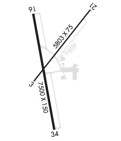
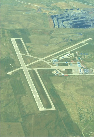
800; TPA: 800 FT AGL LGT ACFT, 1200 FT AGL LRG ACFT.
Sectional ChartCHEYENNE

Aircraft Data

Operations (Reported)YearlyAvg. Daily
General Aviation Transient 574116
General Aviation Local 368310
Air Taxi 28438
Commerical 100
Commuter 00
Military 410
Aircraft based on Field
General Aviation Singles 58
General Aviation Multi 6
Jet Aircraft 1
General Aviation Helicopters 0
Military Aircraft 0
Gliders 0
Ultralights 0

FAA Services

FSS on field NO
FSS tie-in CASPER
FSS Phone 1-800-WX-BRIEF
Who issues Notams GCC
Notam D service at airport YES
ARTCC Name DENVER

Federal Status

Airport CertificationAIRPORT RECEIVING SCHEDULED AIR CARRIER SERVICE FROM CARRIERS CERTIFICATED BY THE CIVIL AERONAUTICS BOARD; PPR UNSKED ACR OPNS WITH MORE THAN 30 PSGR SEATS CALL AMGR 307-686-1042.
Aircraft Rescue & Firefighting IndexAIRPORT HAS A CERTIFICATE UNDER CFR PART 139
Airport of EntryNo
Custom Landing RightsNo
Joint Civil/MilitaryNo
Military Landing rightsYES

Federal Agreements

NATIONAL PLAN OF INTEGRATED AIRPORT SYSTEMS (NPIAS)
GRANT AGREEMENTS UNDER FAAP/ADAP/AIP
ASSURANCES PURSUANT TO TITLE VI, CIVIL RIGHTS ACT OF 1964

Remarks

OPN ON UNPAVED SFCS PROHIBITED.
MINING/BLASTING OPNS 1/2 MILE NE AER 21 DURG DALGT HRS.
MIGRATORY WATERFOWL INVOF ARPT.
CONDS UNMON.
FOR CD CTC DENVER ARTCC AT 303-651-4257.
Airport Communications & Frequencies:
CTAF Frequency:
118.500
Unicom Frequency:
122.950
Remarks
  • APCH/DEP CTL SVC PRVDD BY DENVER ARTCC (ZDV) ON FREQS 135.6/363.025 (SUNDANCE RCAG).
  • Runway Identifications
    Runway Identification: 03/21
    Length: 5804 ft
    Width: 75 ft
    Surface: CONCRETE-GOOD CONDITION
    Edge lights: Medium Intensity

    Treatment: GROOVED
    Weight: PCN 13 /R/D/W/T

     Runway: 03   Runway: 21
    Mag heading: 29°Mag heading: 209°
    Rwy Slope: -.45% DownRwy Slope: .45% Up
    Approach: Approach:
    Pattern: Left TrafficPattern: Left Traffic
    Markings: NONPRECISION INSTRUMENTMarkings: NONPRECISION INSTRUMENT
    Marking Condition: GOODMarking Condition: GOOD
    Arresting Dev: Arresting Dev:
    Lat & Long: N4420.7  W10532.6Lat. & Long.: N4421.5  W10531.8
    Elev: 4343.0 ft. MSLElev: 4317.0 ft. MSL
    TCH: 41 ft. AGLTCH: 39 ft. AGL
    Visual Glide Path: 4.00 degreesVisual Glide Path: 4.00 degrees
    Displaced Threshold: NoDisplaced Threshold: No
    Touchdown Zone: YESTouchdown Zone: YES
    Touchdown Elev.: 4343.1 feetTouchdown Elev.: 4324.9 feet
    Visual Glide Slope: 4-Light PAPI on LEFT side of RunwayVisual Glide Slope: 4-Light PAPI on LEFT side of Runway
    RVR Equipment: RVR Equipment:
    RVV Equipment: NORVV Equipment: NO
    Approach Lights: Approach Lights:
    REIL: YESREIL: YES
    Centerline Lights: NOCenterline Lights: NO
    Touchdown lights: NOTouchdown lights: NO
    Runway Category: Runway with a Visual ApproachRunway Category: Runway with a Visual Approach
    Declared Distances: TORA:5803' TODA:5803' ASDA:5803' LDA:5803'Declared Distances: TORA:5803' TODA:5803' ASDA:5803' LDA:5803'
    Runway Identification: 16/34
    Length: 7501 ft
    Width: 150 ft
    Surface: CONCRETE-GOOD CONDITION
    Edge lights: High Intensity

    Treatment: GROOVED
    Weight: PCN 35 /R/C/W/T

     Runway: 16   Runway: 34
    Mag heading: 161°Mag heading: 341°
    Rwy Slope: .37% UpRwy Slope: -.37% Down
    Approach: Approach: ILS/DME
    Pattern: Left TrafficPattern: Left Traffic
    Markings: PRECISION INSTRUMENTMarkings: PRECISION INSTRUMENT
    Marking Condition: GOODMarking Condition: GOOD
    Arresting Dev: Arresting Dev:
    Lat & Long: N4421.4  W10532.6Lat. & Long.: N4420.2  W10532.3
    Elev: 4337.0 ft. MSLElev: 4364.9 ft. MSL
    TCH: 43 ft. AGLTCH: 56 ft. AGL
    Visual Glide Path: 3.17 degreesVisual Glide Path: 3.20 degrees
    Displaced Threshold: NoDisplaced Threshold: No
    Touchdown Zone: YESTouchdown Zone: YES
    Touchdown Elev.: 4337.2 feetTouchdown Elev.: 4365.1 feet
    Visual Glide Slope: 4-Light PAPI on LEFT side of RunwayVisual Glide Slope: 4-Light PAPI on LEFT side of Runway
    RVR Equipment: RVR Equipment:
    RVV Equipment: NORVV Equipment: NO
    Approach Lights: Approach Lights: MALSR - 1,400 foot medium intensity approach lighting system with runway alignment indicator lights
    REIL: YESREIL: NO
    Centerline Lights: NOCenterline Lights: NO
    Touchdown lights: NOTouchdown lights: NO
    Runway Category: Runway with a Non-precision Approach having visibility minimums greater than 3/4 mileRunway Category: Precision Instrument Runway
    Declared Distances: TORA:7500' TODA:7500' ASDA:7500' LDA:7500'Declared Distances: TORA:7500' TODA:7500' ASDA:7500' LDA:7500'
    Obstructions: ROAD; +56 FT BLDG 1600 FT FM RWY END 568 FT R.Obstructions: PLINE
    Marked: NOT Marked/LightedMarked: NOT Marked/Lighted
    Clearance slope: 25:1Clearance slope: 30:1
    Obstruction height: 56 feet AGLObstruction height: 312 feet AGL
    Dist. from runway: 1600 feetDist. from runway: 9732 feet
    Centerline offset: Centerline offset: 1351 feet right of centerline
    Comments: Comments:
    C:19/P: