Current Weather/Notams (Metars, TAFs, Notams, NWS Forecast, PIREPS, and nearby weather)
Customs Information Send updates to Support@FltPlan.com
Customs Not Available
Database effective 04/18/2024
Airport Diagram might not be current.
|
| Facility Name: | GREAT BEND MUNI |
| City Name: | GREAT BEND |
| County: | BARTON |
| State abbrev: | KS |
| State Name: | KANSAS |
| | |
| Ownership: | PUBLICLY OWNED |
| Use: | OPEN TO THE PUBLIC |
| Owner's Name: | CITY OF GREAT BEND |
| Address: | CITY HALL, BOX 1168 |
| | GREAT BEND, KS 67530 |
| Owner's Phone: | 620-793-4111 |
| | |
| Manager's Name: | MR. MARTIN MILLER |
| Address: | CITY HALL, BOX 1168 |
| | GREAT BEND, KS 67530 |
| Phone: | 620-793-4168; AIRPORT MGR (620) 792-9446 (CELL). |
| | |
| FAA Region: | CENTRAL |
| FAA Field Office: | NONE |
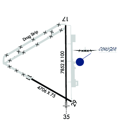
Runway Identifications
Runway Identification: 11/29Length: 4706 ft
Width: 75 ft
Surface: ASPHALT-FAIR CONDITION
Edge lights: Medium IntensityTreatment: NONE
Weight: PCN 9 /R/C/X/U
| | Runway: 11 | | Runway: 29 |
| Mag heading: | 112° | Mag heading: | 292° |
| Rwy Slope: | -.08% Down | Rwy Slope: | .08% Up |
| Approach: | | Approach: | |
| Pattern: | Left Traffic | Pattern: | Left Traffic |
| Markings: | NONPRECISION INSTRUMENT | Markings: | NONPRECISION INSTRUMENT |
| Marking Condition: | GOOD | Marking Condition: | GOOD |
| Arresting Dev: | | Arresting Dev: | |
| Lat & Long: | N3820.6 W09852.2 | Lat. & Long.: | N3820.2 W09851.3 |
| Elev: | 1886.7 ft. MSL | Elev: | 1882.7 ft. MSL |
| TCH: | 38 ft. AGL | TCH: | 43 ft. AGL |
| Visual Glide Path: | 3.00 degrees | Visual Glide Path: | 3.00 degrees |
| Displaced Threshold: | No | Displaced Threshold: | No |
| Touchdown Zone: | YES | Touchdown Zone: | YES |
| Touchdown Elev.: | 1886.7 feet | Touchdown Elev.: | 1884.4 feet |
| Visual Glide Slope: | 4-Light PAPI on LEFT side of Runway | Visual Glide Slope: | 4-Light PAPI on LEFT side of Runway |
| RVR Equipment: | | RVR Equipment: | |
| RVV Equipment: | NO | RVV Equipment: | NO |
| Approach Lights: | | Approach Lights: | |
| REIL: | NO | REIL: | NO |
| Centerline Lights: | NO | Centerline Lights: | NO |
| Touchdown lights: | NO | Touchdown lights: | NO |
| Runway Category: | Runway with a Visual Approach | Runway Category: | Runway with a Visual Approach |
| Declared Distances: | TORA:4706' TODA:4706' ASDA:4706' LDA:4706' | Declared Distances: | TORA:4706' TODA:4706' ASDA:4706' LDA:4706' |
Runway Identification: 17/35Length: 7852 ft
Width: 100 ft
Surface: CONCRETE-FAIR CONDITION
Edge lights: Medium IntensityTreatment: AGGREGATE FRICTION SEAL COAT
Weight: PCN 19 /R/C/X/U
| | Runway: 17 | | Runway: 35 |
| Mag heading: | 172° | Mag heading: | 352° |
| Rwy Slope: | .02% Up | Rwy Slope: | -.02% Down |
| Approach: | | Approach: | ILS/DME |
| Pattern: | Left Traffic | Pattern: | Left Traffic |
| Markings: | NONPRECISION INSTRUMENT | Markings: | PRECISION INSTRUMENT |
| Marking Condition: | GOOD | Marking Condition: | GOOD |
| Arresting Dev: | | Arresting Dev: | |
| Lat & Long: | N3821.5 W09851.4 | Lat. & Long.: | N3820.2 W09851.4 |
| Elev: | 1881.3 ft. MSL | Elev: | 1882.5 ft. MSL |
| TCH: | 38 ft. AGL | TCH: | 50 ft. AGL |
| Visual Glide Path: | 3.50 degrees | Visual Glide Path: | 3.00 degrees |
| Displaced Threshold: | No | Displaced Threshold: | No |
| Touchdown Zone: | YES | Touchdown Zone: | YES |
| Touchdown Elev.: | 1884.6 feet | Touchdown Elev.: | 1883.4 feet |
| Visual Glide Slope: | 4-Light PAPI on LEFT side of Runway | Visual Glide Slope: | 4-BOX VASI ON LEFT SIDE OF RUNWAY |
| RVR Equipment: | | RVR Equipment: | |
| RVV Equipment: | NO | RVV Equipment: | NO |
| Approach Lights: | | Approach Lights: | MALSR - 1,400 foot medium intensity approach lighting system with runway alignment indicator lights |
| REIL: | YES | REIL: | NO |
| Centerline Lights: | NO | Centerline Lights: | NO |
| Touchdown lights: | NO | Touchdown lights: | NO |
| Runway Category: | D | Runway Category: | Precision Instrument Runway |
| Declared Distances: | TORA:7852' TODA:7852' ASDA:7852' LDA:7852' | Declared Distances: | TORA:7852' TODA:7852' ASDA:7852' LDA:7852' |

