
| ||||||||||||||||||||||||||||||||||||||||||||
| ||||||||||||||||||||||||||||||||||||||||||||
| ||||||||||||||||||||||||||||||||||||||||||||
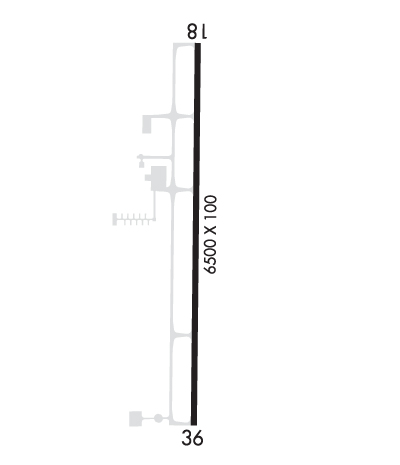
| Rwy | Rwy | |||||||
| 6500x100 | 6500' | 6500x100 | 6500' | 109.10 - 358° | ||||
| Runway ID | Single Wheel | Double Wheel | Double Tandem Wheel | Dual Double Wheel |
| 18/36 | 60,000 | 75,000 | N/A | N/A |
| H1 | N/A | N/A | N/A | N/A |
| These numbers are Advisory and are not limits. The Airport Manager should have more accurate Weight Limits | ||||
 Airport Diagram might not be current. | |
| Facility Name: | SOUTH LAFOURCHE LEONARD MILLER JR |
| City Name: | GALLIANO |
| County: | LAFOURCHE |
| State abbrev: | LA |
| State Name: | LOUISIANA |
| Ownership: | PUBLICLY OWNED |
| Use: | OPEN TO THE PUBLIC |
| Owner's Name: | GREATER LAFOURCHE PORT COMMISSION |
| Address: | 16829 EAST MAIN |
| CUTOFF, LA 70345 | |
| Owner's Phone: | 985-632-6701 |
| Manager's Name: | GWAYNE GAUTREAUX |
| Address: | 16829 EAST MAIN |
| CUTOFF, LA 70345 | |
| Phone: | 985-291-0818; AFT HRS PHONE 985-475-6701. |
| FAA Region: | SOUTHWEST |
| FAA Field Office: | LNM |
| Date | Sunrise | Sunset |
|---|---|---|
| 04/17/24 Wednesday | 6:32 | 19:29 |
| 04/18/24 Thursday | 6:31 | 19:30 |
| 04/19/24 Friday | 6:30 | 19:31 |
| 04/20/24 Saturday | 6:29 | 19:31 |
| 04/21/24 Sunday | 6:28 | 19:32 |
| 04/22/24 Monday | 6:27 | 19:33 |
| 04/23/24 Tuesday | 6:26 | 19:33 |
| 04/24/24 Wednesday | 6:25 | 19:34 |
| 04/25/24 Thursday | 6:24 | 19:34 |
| 04/26/24 Friday | 6:23 | 19:35 |
| 04/27/24 Saturday | 6:22 | 19:36 |
| 04/28/24 Sunday | 6:21 | 19:36 |
| 04/29/24 Monday | 6:20 | 19:37 |
| 04/30/24 Tuesday | 6:19 | 19:37 |
| Airport Attendance Schedule | CONTINUOUS |
| Airport Status | OPERATIONAL (This Status can change at any time - please check NOTAMS) |
| Airport Lighting Schedule | SSALR RWY 36; REIL RWY 18 AND MIRL RWY 18/36 PRESET LOW INTST DUSK-DAWN; TO INCR INTST ACTVT - CTAF. |
| Airport Storage Available | Tie Downs, Hanger |
| Extra Services Available | Avionics |
| Wind Indicator | YES - (lighted) |
| Control Tower | NO |
| CTAF Frequency | 123.000 |
| Unicom Frequency | 123.000 |
| Rotating Beacon Color | WG |
| Segmented Circle | YES |
| Landing Fee |
| Airport Inspected | STATE - performed by STATE AERONAUTICAL PERSONNEL |
| Inspection Date | 07/20/2023 |
| Type of Fuel Available | Grade 100LL, JET A-1 (icing inhibitor, freeze point -50C); -10FUEL AVBL 24/7 WITH CC. |
| Airframe Repair Service | NONE |
| Power Plant Repair Service | NONE |
| Latitude | N2926.5 |
| Longitude | W09015.7 (ESTIMATED) |
| Arpt Elevation | 0ft (SURVEYED) |
| Magnetic Variation | 02E |
| 1 miles E | of GALLIANO |
| Traffic Pattern Altitude | |
| Sectional Chart | NEW ORLEANS |
| Operations (Reported) | Yearly | Avg. Daily |
|---|---|---|
| General Aviation Transient | 5083 | 14 |
| General Aviation Local | 18956 | 52 |
| Air Taxi | 0 | 0 |
| Commerical | 0 | 0 |
| Commuter | 0 | 0 |
| Military | 50 | 0 |
| Aircraft based on Field | |
|---|---|
| General Aviation Singles | 4 |
| General Aviation Multi | 0 |
| Jet Aircraft | 3 |
| General Aviation Helicopters | 37 |
| Military Aircraft | 0 |
| Gliders | 0 |
| Ultralights | 0 |
| FSS on field | NO |
| FSS tie-in | DE RIDDER |
| FSS Phone | 1-800-WX-BRIEF |
| Who issues Notams | DRI |
| Notam D service at airport | YES |
| ARTCC Name | HOUSTON |
| Airport Certification | |
| Aircraft Rescue & Firefighting Index | None |
| Airport of Entry | No |
| Custom Landing Rights | YES |
| Joint Civil/Military | No |
| Military Landing rights | No |
| NATIONAL PLAN OF INTEGRATED AIRPORT SYSTEMS (NPIAS) |
| GRANT AGREEMENTS UNDER FAAP/ADAP/AIP |
| ASSURANCES PURSUANT TO TITLE VI, CIVIL RIGHTS ACT OF 1964 |
| ALL SFC WORK IN PROG MOWING. BIRD ACTY INVOF RWY 18/36. |
| FOR CD CTC NEW ORLEANS APCH AT 504-471-4350 OR 120.85. |
| RWY H1 H1 CLSD INDEFLY. |
Airport Communications & Frequencies:
| ||||||||||||||||
| Runway: 18 | Runway: 36 | ||
| Mag heading: | 178° | Mag heading: | 358° |
| Rwy Slope: | -.03% Down | Rwy Slope: | .03% Up |
| Approach: | Approach: | ILS/DME | |
| Pattern: | Left Traffic | Pattern: | Left Traffic |
| Markings: | NONPRECISION INSTRUMENT | Markings: | PRECISION INSTRUMENT |
| Marking Condition: | GOOD | Marking Condition: | GOOD |
| Arresting Dev: | Arresting Dev: | ||
| Lat & Long: | N2927.0 W09015.7 | Lat. & Long.: | N2925.9 W09015.7 |
| Elev: | 0.0 ft. MSL | Elev: | -2.0 ft. MSL |
| TCH: | 38 ft. AGL | TCH: | 50 ft. AGL |
| Visual Glide Path: | 3.00 degrees | Visual Glide Path: | 3.00 degrees |
| Displaced Threshold: | No | Displaced Threshold: | No |
| Touchdown Zone: | YES | Touchdown Zone: | YES |
| Touchdown Elev.: | 0.0 feet | Touchdown Elev.: | -1.8 feet |
| Visual Glide Slope: | 4-Light PAPI on LEFT side of Runway | Visual Glide Slope: | 4-Light PAPI on LEFT side of Runway |
| RVR Equipment: | RVR Equipment: | ||
| RVV Equipment: | NO | RVV Equipment: | NO |
| Approach Lights: | Approach Lights: | SSALR - simplified short approach lighting system with runway alignment indicator lights | |
| REIL: | YES | REIL: | NO |
| Centerline Lights: | NO | Centerline Lights: | NO |
| Touchdown lights: | NO | Touchdown lights: | NO |
| Runway Category: | Runway with a Non-precision Approach having visibility minimums greater than 3/4 mile | Runway Category: | Runway with a Non-precision Approach having visibility minimums greater than 3/4 mile |
| Declared Distances: | Declared Distances: | ||
| Obstructions: | TREES | Obstructions: | |
| Marked: | NOT Marked/Lighted | Marked: | |
| Clearance slope: | 30:1 | Clearance slope: | 50:1 |
| Obstruction height: | 70 feet AGL | Obstruction height: | |
| Dist. from runway: | 2306 feet | Dist. from runway: | |
| Centerline offset: | 540 left of centerline | Centerline offset: | |
| Comments: | Comments: |