Current Weather/Notams (Metars, TAFs, Notams, NWS Forecast, PIREPS, and nearby weather)
Customs Information Send updates to Support@FltPlan.com
Customs Not Available
Database effective 05/16/2024
Airport Diagram might not be current.
|
| Facility Name: | NORTHEAST ALABAMA RGNL |
| City Name: | GADSDEN |
| County: | ETOWAH |
| State abbrev: | AL |
| State Name: | ALABAMA |
| | |
| Ownership: | PUBLICLY OWNED |
| Use: | OPEN TO THE PUBLIC |
| Owner's Name: | GADSDEN AIRPORT AUTHORITY |
| Address: | 185 IRA GRAY DR. |
| | GADSDEN, AL 35904 |
| Owner's Phone: | 256-442-3313 |
| | |
| Manager's Name: | ANTHONY TARVER |
| Address: | 185 IRA GRAY DRIVE |
| | GADSDEN, AL 35904 |
| Phone: | 256-328-4700 |
| | |
| FAA Region: | SOUTHERN |
| FAA Field Office: | JAN |
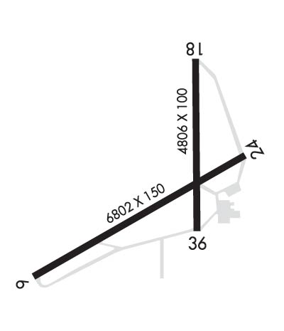
Runway Identifications
Runway Identification: 06/24Length: 6802 ft
Width: 150 ft
Surface: ASPHALT-FAIR CONDITION
Edge lights: High IntensityTreatment: GROOVED
| | Runway: 06 | | Runway: 24 |
| Mag heading: | 64° | Mag heading: | 244° |
| Rwy Slope: | -.29% Down | Rwy Slope: | .29% Up |
| Approach: | | Approach: | ILS/DME |
| Pattern: | Left Traffic | Pattern: | Left Traffic |
| Markings: | PRECISION INSTRUMENT | Markings: | PRECISION INSTRUMENT |
| Marking Condition: | FAIR | Marking Condition: | FAIR |
| Arresting Dev: | | Arresting Dev: | |
| Lat & Long: | N3358.0 W08606.1 | Lat. & Long.: | N3358.5 W08604.9 |
| Elev: | 569.2 ft. MSL | Elev: | 549.3 ft. MSL |
| TCH: | 40 ft. AGL | TCH: | 45 ft. AGL |
| Visual Glide Path: | 3.00 degrees | Visual Glide Path: | 3.00 degrees |
| Displaced Threshold: | No | Displaced Threshold: | No |
| Touchdown Zone: | YES | Touchdown Zone: | YES |
| Touchdown Elev.: | 569.2 feet | Touchdown Elev.: | 560.1 feet |
| Visual Glide Slope: | 4-Light PAPI on LEFT side of Runway | Visual Glide Slope: | 4-Light PAPI on LEFT side of Runway |
| RVR Equipment: | | RVR Equipment: | |
| RVV Equipment: | NO | RVV Equipment: | NO |
| Approach Lights: | | Approach Lights: | |
| REIL: | YES | REIL: | YES |
| Centerline Lights: | NO | Centerline Lights: | NO |
| Touchdown lights: | NO | Touchdown lights: | NO |
| Runway Category: | D | Runway Category: | Precision Instrument Runway |
| Declared Distances: | | Declared Distances: | |
| Obstructions: | TREE | Obstructions: | TREE |
| Marked: | NOT Marked/Lighted | Marked: | NOT Marked/Lighted |
| Clearance slope: | 27:1 | Clearance slope: | 45:1 |
| Obstruction height: | 52 feet AGL | Obstruction height: | 55 feet AGL |
| Dist. from runway: | 1621 feet | Dist. from runway: | 2724 feet |
| Centerline offset: | 222 right of centerline | Centerline offset: | 172 feet left of centerline |
| Comments: | | Comments: | |
Runway Identification: 18/36Length: 4806 ft
Width: 100 ft
Surface: ASPHALT-FAIR CONDITION
Edge lights: Medium IntensityTreatment: NONE
| | Runway: 18 | | Runway: 36 |
| Mag heading: | 183° | Mag heading: | 3° |
| Rwy Slope: | .23% Up | Rwy Slope: | -.23% Down |
| Approach: | | Approach: | |
| Pattern: | Left Traffic | Pattern: | Left Traffic |
| Markings: | NONPRECISION INSTRUMENT | Markings: | NONPRECISION INSTRUMENT |
| Marking Condition: | FAIR; MARKINGS FADED. | Marking Condition: | FAIR; MARKINGS FADED. |
| Arresting Dev: | | Arresting Dev: | |
| Lat & Long: | N3358.9 W08605.2 | Lat. & Long.: | N3358.2 W08605.2 |
| Elev: | 541.9 ft. MSL | Elev: | 553.0 ft. MSL |
| TCH: | 42 ft. AGL | TCH: | 40 ft. AGL |
| Visual Glide Path: | 2.75 degrees | Visual Glide Path: | 2.75 degrees |
| Displaced Threshold: | No | Displaced Threshold: | No |
| Touchdown Zone: | YES | Touchdown Zone: | YES |
| Touchdown Elev.: | 553.2 feet | Touchdown Elev.: | 554.9 feet |
| Visual Glide Slope: | 2-Light PAPI on LEFT side of Runway | Visual Glide Slope: | 2-Light PAPI on LEFT side of Runway |
| RVR Equipment: | | RVR Equipment: | |
| RVV Equipment: | NO | RVV Equipment: | NO |
| Approach Lights: | | Approach Lights: | |
| REIL: | NO | REIL: | NO |
| Centerline Lights: | NO | Centerline Lights: | NO |
| Touchdown lights: | NO | Touchdown lights: | NO |
| Runway Category: | Runway with a Non-precision Approach having visibility minimums greater than 3/4 mile | Runway Category: | Runway with a Non-precision Approach having visibility minimums greater than 3/4 mile |
| Declared Distances: | | Declared Distances: | |
| Obstructions: | TREE | Obstructions: | TREE |
| Marked: | NOT Marked/Lighted | Marked: | NOT Marked/Lighted |
| Clearance slope: | 17:1 | Clearance slope: | 25:1 |
| Obstruction height: | 27 feet AGL | Obstruction height: | 67 feet AGL |
| Dist. from runway: | 677 feet | Dist. from runway: | 1883 feet |
| Centerline offset: | 105 right of centerline | Centerline offset: | 127 feet right of centerline |
| Comments: | | Comments: | |

