
| ||||||||||||||||||||||||||||||||||||||||||||
| ||||||||||||||||||||||||||||||||||||||||||||
| ||||||||||||||||||||||||||||||||||||||||||||
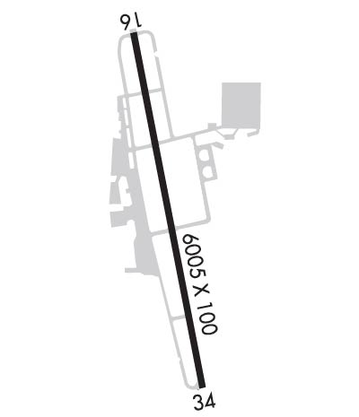
| Rwy | Rwy | |||||||
| 6005x100 | 6005' | 111.90 - 166° | 6005x100 | 6005' | 111.90 - 352° | |||
| Runway ID | Single Wheel | Double Wheel | Double Tandem Wheel | Dual Double Wheel |
| 16/34 | 90,000 | 150,000 | 175,000 | N/A |
| These numbers are Advisory and are not limits. The Airport Manager should have more accurate Weight Limits | ||||
 Airport Diagram might not be current. | |
| Facility Name: | DRAKE FLD |
| City Name: | FAYETTEVILLE |
| County: | WASHINGTON |
| State abbrev: | AR |
| State Name: | ARKANSAS |
| Ownership: | PUBLICLY OWNED |
| Use: | OPEN TO THE PUBLIC |
| Owner's Name: | CITY OF FAYETTEVILLE |
| Address: | 113 MOUNTAIN ST |
| FAYETTEVILLE, AR 72701 | |
| Owner's Phone: | 479-575-8330 |
| Manager's Name: | JARED RABREN; DIRECTOR, AVIATION. |
| Address: | 4500 S SCHOOL SUITE F |
| FAYETTEVILLE, AR 72701 | |
| Phone: | (479) 718-7644 |
| FAA Region: | SOUTHWEST |
| FAA Field Office: | AOK |
| Date | Sunrise | Sunset |
|---|---|---|
| 04/24/24 Wednesday | 6:31 | 19:59 |
| 04/25/24 Thursday | 6:30 | 20:00 |
| 04/26/24 Friday | 6:29 | 20:00 |
| 04/27/24 Saturday | 6:28 | 20:01 |
| 04/28/24 Sunday | 6:27 | 20:02 |
| 04/29/24 Monday | 6:25 | 20:03 |
| 04/30/24 Tuesday | 6:24 | 20:04 |
| 05/01/24 Wednesday | 6:23 | 20:05 |
| 05/02/24 Thursday | 6:22 | 20:05 |
| 05/03/24 Friday | 6:21 | 20:06 |
| 05/04/24 Saturday | 6:20 | 20:07 |
| 05/05/24 Sunday | 6:19 | 20:08 |
| 05/06/24 Monday | 6:18 | 20:09 |
| 05/07/24 Tuesday | 6:17 | 20:10 |
| Airport Attendance Schedule | MON-FRI 0600-2200, SAT-SUN 0800-2000 |
| Airport Status | OPERATIONAL (This Status can change at any time - please check NOTAMS) |
| Airport Lighting Schedule | WHEN ATCT CLSD MIRL RWY 16/34 PRESET MED INTST. ACTVT ODALS RWY 16 & 34; PAPI RWY 34 - CTAF. |
| Airport Storage Available | Tie Downs, Hanger |
| Extra Services Available | Air Freight, Avionics, Cargo Handling, Charter, Flight Instruction |
| Wind Indicator | YES - (lighted) |
| Control Tower | YES |
| CTAF Frequency | 128.000 |
| Unicom Frequency | 122.950 |
| Rotating Beacon Color | WG |
| Segmented Circle | NO |
| Landing Fee | NO |
| Airport Inspected | FEDERAL - performed by FAA AIRPORTS FIELD PERSONNEL |
| Inspection Date | 07/19/2023 |
| Type of Fuel Available | Grade 100LL, JET A (freeze point -40C); -10FOR FUEL AFTER HRS CALL 479-443-4343; FEE CHARGED. SELF SERVICE AVBL 24 HRS. |
| Airframe Repair Service | MINOR |
| Power Plant Repair Service | MINOR |
| Latitude | N3600.3 |
| Longitude | W09410.2 (ESTIMATED) |
| Arpt Elevation | 1252ft (SURVEYED) |
| Magnetic Variation | 02E |
| 3 miles S | of FAYETTEVILLE |
| Traffic Pattern Altitude | 849 |
| Sectional Chart | KANSAS CITY |
| Operations (Reported) | Yearly | Avg. Daily |
|---|---|---|
| General Aviation Transient | 15877 | 43 |
| General Aviation Local | 8487 | 23 |
| Air Taxi | 1522 | 4 |
| Commerical | 92 | 0 |
| Commuter | 0 | 0 |
| Military | 790 | 2 |
| Aircraft based on Field | |
|---|---|
| General Aviation Singles | 88 |
| General Aviation Multi | 6 |
| Jet Aircraft | 17 |
| General Aviation Helicopters | 2 |
| Military Aircraft | 0 |
| Gliders | 0 |
| Ultralights | 0 |
| FSS on field | NO |
| FSS tie-in | JONESBORO |
| FSS Phone | 1-800-WX-BRIEF |
| Who issues Notams | FYV |
| Notam D service at airport | YES |
| ARTCC Name | MEMPHIS |
| Airport Certification | 24 HR PPR FOR ACR OPNS WITH MORE THAN 30 PSGR SEATS CALL AMGR 479-718-7642 & FAX FBO 479-718-7646. |
| Aircraft Rescue & Firefighting Index | AIRPORT HAS A CERTIFICATE UNDER CFR PART 139 |
| Airport of Entry | No |
| Custom Landing Rights | No |
| Joint Civil/Military | No |
| Military Landing rights | YES |
| NATIONAL PLAN OF INTEGRATED AIRPORT SYSTEMS (NPIAS) |
| GRANT AGREEMENTS UNDER FAAP/ADAP/AIP |
| ASSURANCES PURSUANT TO TITLE VI, CIVIL RIGHTS ACT OF 1964 |
| DEER ON & INVOF ARPT. |
| FOR CD CTC MEMPHIS ARTCC AT 901-368-8453/8449. |
Airport Communications & Frequencies:
| |||||||||||||||||||||||||
| Runway: 16 | Runway: 34 | ||
| Mag heading: | 167° | Mag heading: | 347° |
| Rwy Slope: | -.21% Down | Rwy Slope: | .21% Up |
| Approach: | LOC/DME | Approach: | LDA/DME |
| Pattern: | Left Traffic | Pattern: | Left Traffic |
| Markings: | PRECISION INSTRUMENT | Markings: | PRECISION INSTRUMENT |
| Marking Condition: | GOOD | Marking Condition: | GOOD |
| Arresting Dev: | Arresting Dev: | ||
| Lat & Long: | N3600.8 W09410.3 | Lat. & Long.: | N3559.8 W09410.1 |
| Elev: | 1250.8 ft. MSL | Elev: | 1237.9 ft. MSL |
| TCH: | 50 ft. AGL | TCH: | 58 ft. AGL |
| Visual Glide Path: | 3.00 degrees | Visual Glide Path: | 3.50 degrees |
| Displaced Threshold: | No | Displaced Threshold: | No |
| Touchdown Zone: | YES | Touchdown Zone: | YES |
| Touchdown Elev.: | 1252.0 feet | Touchdown Elev.: | 1241.3 feet |
| Visual Glide Slope: | 4-Light PAPI on LEFT side of Runway | Visual Glide Slope: | 4-Light PAPI on LEFT side of Runway |
| RVR Equipment: | RVR Equipment: | ||
| RVV Equipment: | NO | RVV Equipment: | NO |
| Approach Lights: | ODALS - omnidirectional approach lighting system | Approach Lights: | ODALS - omnidirectional approach lighting system |
| REIL: | NO | REIL: | NO |
| Centerline Lights: | NO | Centerline Lights: | NO |
| Touchdown lights: | NO | Touchdown lights: | NO |
| Runway Category: | Runway with a Non-precision Approach having visibility minimums greater than 3/4 mile | Runway Category: | Precision Instrument Runway |
| Declared Distances: | TORA:6005' TODA:6005' ASDA:6005' LDA:6005' | Declared Distances: | TORA:6005' TODA:6005' ASDA:6005' LDA:6005' |
| Obstructions: | Obstructions: | TREE | |
| Marked: | Marked: | NOT Marked/Lighted | |
| Clearance slope: | 50:1 | Clearance slope: | 20:1 |
| Obstruction height: | Obstruction height: | 263 feet AGL | |
| Dist. from runway: | Dist. from runway: | 5585 feet | |
| Centerline offset: | Centerline offset: | 958 feet right of centerline | |
| Comments: | Comments: |