Current Weather/Notams (Metars, TAFs, Notams, NWS Forecast, PIREPS, and nearby weather)
Customs Information Send updates to Support@FltPlan.com
Customs Not Available
Database effective 05/16/2024
Airport Diagram might not be current.
|
| Facility Name: | FOREST CITY MUNI |
| City Name: | FOREST CITY |
| County: | HANCOCK |
| State abbrev: | IA |
| State Name: | IOWA |
| | |
| Ownership: | PUBLICLY OWNED |
| Use: | OPEN TO THE PUBLIC |
| Owner's Name: | CITY OF FOREST CITY |
| Address: | 305 N. CLARK |
| | FOREST CITY, IA 50436 |
| Owner's Phone: | 641-585-3574 |
| | |
| Manager's Name: | R.TRIMBLE |
| Address: | MUNICIPAL ARPT, 1842 330TH ST |
| | FOREST CITY, IA 50436 |
| Phone: | 641-581-2880; RESIDENCE - 641-585-2166. |
| | |
| FAA Region: | CENTRAL |
| FAA Field Office: | NONE |
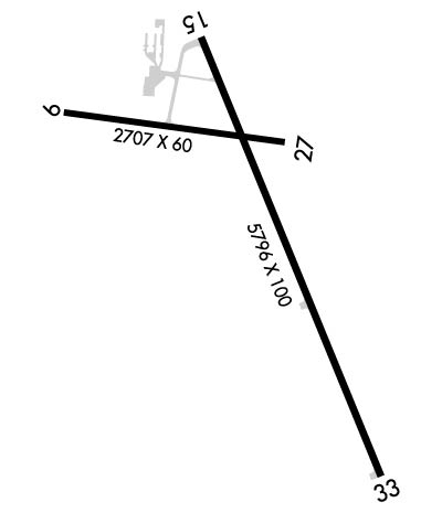
Runway Identifications
Runway Identification: 09/27Length: 2707 ft
Width: 60 ft
Surface: ASPHALT-GOOD CONDITION
Edge lights: Medium IntensityTreatment: NONE
Weight: PCN 4 /F/C/X/U
| | Runway: 09 | | Runway: 27 |
| Mag heading: | 92° | Mag heading: | 272° |
| Rwy Slope: | -.95% Down | Rwy Slope: | .95% Up |
| Approach: | | Approach: | |
| Pattern: | Left Traffic | Pattern: | Left Traffic |
| Markings: | BASIC | Markings: | BASIC |
| Marking Condition: | FAIR | Marking Condition: | FAIR |
| Arresting Dev: | | Arresting Dev: | |
| Lat & Long: | N4314.3 W09338.0 | Lat. & Long.: | N4314.2 W09337.4 |
| Elev: | 1229.2 ft. MSL | Elev: | 1203.4 ft. MSL |
| TCH: | | TCH: | |
| Visual Glide Path: | | Visual Glide Path: | |
| Displaced Threshold: | No | Displaced Threshold: | No |
| Touchdown Zone: | YES | Touchdown Zone: | YES |
| Touchdown Elev.: | 1229.2 feet | Touchdown Elev.: | 1229.2 feet |
| Visual Glide Slope: | | Visual Glide Slope: | |
| RVR Equipment: | | RVR Equipment: | |
| RVV Equipment: | NO | RVV Equipment: | NO |
| Approach Lights: | | Approach Lights: | |
| REIL: | NO | REIL: | NO |
| Centerline Lights: | NO | Centerline Lights: | NO |
| Touchdown lights: | NO | Touchdown lights: | NO |
| Runway Category: | Runway with a Visual Approach | Runway Category: | Runway with a Visual Approach |
| Declared Distances: | | Declared Distances: | |
| Obstructions: | TREE | Obstructions: | TREE |
| Marked: | NOT Marked/Lighted | Marked: | NOT Marked/Lighted |
| Clearance slope: | 13:1 | Clearance slope: | 2:1 |
| Obstruction height: | 34 feet AGL | Obstruction height: | 11 feet AGL |
| Dist. from runway: | 645 feet | Dist. from runway: | 231 feet |
| Centerline offset: | 121 left of centerline | Centerline offset: | 49 feet right of centerline |
| Comments: | | Comments: | |
Runway Identification: 15/33Length: 5796 ft
Width: 100 ft
Surface: ASPHALT-GOOD CONDITION
Edge lights: Medium IntensityTreatment: NONE
| | Runway: 15 | | Runway: 33 |
| Mag heading: | 152° | Mag heading: | 332° |
| Rwy Slope: | -.07% Down | Rwy Slope: | .07% Up |
| Approach: | | Approach: | |
| Pattern: | Left Traffic | Pattern: | Left Traffic |
| Markings: | NONPRECISION INSTRUMENT | Markings: | NONPRECISION INSTRUMENT |
| Marking Condition: | GOOD | Marking Condition: | GOOD |
| Arresting Dev: | | Arresting Dev: | |
| Lat & Long: | N4314.4 W09337.6 | Lat. & Long.: | N4313.6 W09337.1 |
| Elev: | 1206.7 ft. MSL | Elev: | 1202.8 ft. MSL |
| TCH: | 28 ft. AGL | TCH: | 40 ft. AGL |
| Visual Glide Path: | 3.00 degrees | Visual Glide Path: | 3.00 degrees |
| Displaced Threshold: | 600 feet; 34:1 TO DISPLACED THRESHOLD | Displaced Threshold: | No |
| Touchdown Zone: | YES | Touchdown Zone: | YES |
| Touchdown Elev.: | 1204.3 feet | Touchdown Elev.: | 1203.3 feet |
| Visual Glide Slope: | 2-Light PAPI on LEFT side of Runway | Visual Glide Slope: | 2-Light PAPI on LEFT side of Runway |
| RVR Equipment: | | RVR Equipment: | |
| RVV Equipment: | NO | RVV Equipment: | NO |
| Approach Lights: | | Approach Lights: | |
| REIL: | YES | REIL: | YES |
| Centerline Lights: | NO | Centerline Lights: | NO |
| Touchdown lights: | NO | Touchdown lights: | NO |
| Runway Category: | Runway with a Non-precision Approach having visibility minimums greater than 3/4 mile | Runway Category: | Runway with a Non-precision Approach having visibility minimums greater than 3/4 mile |
| Declared Distances: | | Declared Distances: | |
| Obstructions: | TREES | Obstructions: | FENCE |
| Marked: | NOT Marked/Lighted | Marked: | NOT Marked/Lighted |
| Clearance slope: | 14:1 | Clearance slope: | 28:1 |
| Obstruction height: | 39 feet AGL | Obstruction height: | 5 feet AGL |
| Dist. from runway: | 750 feet | Dist. from runway: | 315 feet |
| Centerline offset: | 10 left of centerline | Centerline offset: | |
| Comments: | | Comments: | |

