Current Weather/Notams (Metars, TAFs, Notams, NWS Forecast, PIREPS, and nearby weather)
Customs Information Send updates to Support@FltPlan.com
Customs Not Available
Database effective 05/16/2024
Airport Diagram might not be current. Facility Name: FORT WORTH SPINKS City Name: FORT WORTH County: TARRANT State abbrev: TX State Name: TEXAS Ownership: PUBLICLY OWNED Use: OPEN TO THE PUBLIC Owner's Name: CITY OF FORT WORTH Address: 201 AMERICAN CONCOURSE, SUITE 330 FORT WORTH, TX 76106 Owner's Phone: 817-392-5400 Manager's Name: JOE HAMMOND Address: 450 ALSBURY CT FORT WORTH, TX 76028 Phone: 817-392-5430 FAA Region: SOUTHWEST FAA Field Office: TEX
Runway Identifications Help
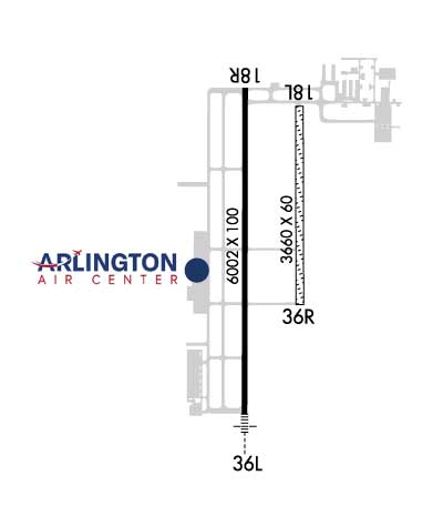
Runway Identification: 18L/36R Length: 3660 ftWidth: 60 ftSurface: GRASS-GOOD CONDITIONEdge lights: Treatment: NONE Runway: 18L Runway: 36R Mag heading: 177° Mag heading: 357° Rwy Slope: .02% Up Rwy Slope: -.02% Down Approach: Approach: Pattern: Left Traffic Pattern: Right Traffic Markings: NONE Markings: NONE Marking Condition: FAIR Marking Condition: FAIR Arresting Dev: Arresting Dev: Lat & Long: N3234.3 W09718.4 Lat. & Long.: N3233.7 W09718.4 Elev: 694.2 ft. MSL Elev: 695.0 ft. MSL TCH: TCH: Visual Glide Path: Visual Glide Path: Displaced Threshold: No Displaced Threshold: No Touchdown Zone: YES Touchdown Zone: YES Touchdown Elev.: 694.2 feet Touchdown Elev.: 695.0 feet Visual Glide Slope: Visual Glide Slope: RVR Equipment: RVR Equipment: RVV Equipment: NO RVV Equipment: NO Approach Lights: Approach Lights: REIL: NO REIL: NO Centerline Lights: NO Centerline Lights: NO Touchdown lights: NO Touchdown lights: NO Runway Category: Runway with a Visual Approach Runway Category: Runway with a Visual Approach Declared Distances: Declared Distances: Obstructions: Obstructions: GND Marked: Marked: NOT Marked/Lighted Clearance slope: 50:1 Clearance slope: 40:1 Obstruction height: Obstruction height: 8 feet AGL Dist. from runway: Dist. from runway: 320 feet Centerline offset: Centerline offset: Comments: Comments:
Runway Identification: 18R/36L Length: 6002 ftWidth: 100 ftSurface: ASPHALT-GOOD CONDITIONEdge lights: Medium Intensity Treatment: NONE Runway: 18R Runway: 36L Mag heading: 177° Mag heading: 357° Rwy Slope: -.19% Down Rwy Slope: .19% Up Approach: Approach: ILS Pattern: Right Traffic Pattern: Left Traffic Markings: PRECISION INSTRUMENT Markings: PRECISION INSTRUMENT Marking Condition: GOOD Marking Condition: GOOD Arresting Dev: Arresting Dev: Lat & Long: N3234.4 W09718.6 Lat. & Long.: N3233.4 W09718.6 Elev: 700.4 ft. MSL Elev: 689.1 ft. MSL TCH: 40 ft. AGL TCH: 50 ft. AGL Visual Glide Path: 3.00 degrees Visual Glide Path: 3.00 degrees Displaced Threshold: No Displaced Threshold: No Touchdown Zone: YES Touchdown Zone: YES Touchdown Elev.: 700.4 feet Touchdown Elev.: 696.5 feet Visual Glide Slope: 4-Light PAPI on LEFT side of Runway Visual Glide Slope: 4-Light PAPI on LEFT side of Runway RVR Equipment: RVR Equipment: RVV Equipment: NO RVV Equipment: NO Approach Lights: Approach Lights: MALSR - 1,400 foot medium intensity approach lighting system with runway alignment indicator lights REIL: NO REIL: NO Centerline Lights: NO Centerline Lights: NO Touchdown lights: NO Touchdown lights: NO Runway Category: Runway with a Non-precision Approach having visibility minimums greater than 3/4 mile Runway Category: Precision Instrument Runway Declared Distances: Declared Distances: Obstructions: PLINE Obstructions: Marked: MARKED Marked: Clearance slope: 39:1 Clearance slope: 50:1 Obstruction height: 100 feet AGL Obstruction height: Dist. from runway: 4150 feet Dist. from runway: Centerline offset: Centerline offset: Comments: Comments: