Current Weather/Notams (Metars, TAFs, Notams, NWS Forecast, PIREPS, and nearby weather)
Customs Information Send updates to Support@FltPlan.com
Customs Not Available
Database effective 04/18/2024
Airport Diagram might not be current. Facility Name: FAIRFIELD MUNI City Name: FAIRFIELD County: WAYNE State abbrev: IL State Name: ILLINOIS Ownership: PUBLICLY OWNED Use: OPEN TO THE PUBLIC Owner's Name: CITY OF FAIRFIELD Address: CITY HALL,109 NE 2ND ST FAIRFIELD, IL 62837 Owner's Phone: 618-842-3871 Manager's Name: TRAVIS WILLIAMS Address: CITY HALL 109 NE 2ND ST FAIRFIELD, IL 62837 Phone: 618-842-9587 FAA Region: GREAT LAKES FAA Field Office: CHI
Runway Identifications Help
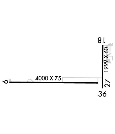
Runway Identification: 09/27 Length: 4000 ftWidth: 75 ftSurface: ASPHALT-GOOD CONDITIONEdge lights: Medium Intensity Treatment: NONE Runway: 09 Runway: 27 Mag heading: 91° Mag heading: 271° Rwy Slope: -.54% Down Rwy Slope: .54% Up Approach: Approach: Pattern: Left Traffic Pattern: Left Traffic Markings: NONPRECISION INSTRUMENT Markings: NONPRECISION INSTRUMENT Marking Condition: FAIR Marking Condition: FAIR Arresting Dev: Arresting Dev: Lat & Long: N3822.7 W08825.3 Lat. & Long.: N3822.7 W08824.5 Elev: 434.4 ft. MSL Elev: 412.8 ft. MSL TCH: 25 ft. AGL TCH: 28 ft. AGL Visual Glide Path: 3.00 degrees Visual Glide Path: 3.00 degrees Displaced Threshold: No Displaced Threshold: No Touchdown Zone: YES Touchdown Zone: YES Touchdown Elev.: 434.4 feet Touchdown Elev.: 423.8 feet Visual Glide Slope: PULSATING/STEADY BURNING VASI ON LEFT SIDE OF RUNWAY Visual Glide Slope: PULSATING/STEADY BURNING VASI ON LEFT SIDE OF RUNWAY RVR Equipment: RVR Equipment: RVV Equipment: NO RVV Equipment: NO Approach Lights: Approach Lights: REIL: YES REIL: NO Centerline Lights: NO Centerline Lights: NO Touchdown lights: NO Touchdown lights: NO Runway Category: Runway with a Non-precision Approach Runway Category: Runway with a Visual Approach Declared Distances: Declared Distances:
Runway Identification: 18/36 Length: 1999 ftWidth: 60 ftSurface: ASPHALT-GOOD CONDITIONEdge lights: Medium Intensity Treatment: NONE Runway: 18 Runway: 36 Mag heading: 182° Mag heading: 2° Rwy Slope: -.12% Down Rwy Slope: .12% Up Approach: Approach: Pattern: Left Traffic Pattern: Left Traffic Markings: BASIC Markings: BASIC Marking Condition: POOR; RWY 18 MARKING FADED. Marking Condition: POOR; RWY 36 MARKING FADED. Arresting Dev: Arresting Dev: Lat & Long: N3823.0 W08824.4 Lat. & Long.: N3822.6 W08824.5 Elev: 415.6 ft. MSL Elev: 413.2 ft. MSL TCH: TCH: Visual Glide Path: Visual Glide Path: Displaced Threshold: No Displaced Threshold: No Touchdown Zone: YES Touchdown Zone: YES Touchdown Elev.: 415.6 feet Touchdown Elev.: 415.6 feet Visual Glide Slope: Visual Glide Slope: RVR Equipment: RVR Equipment: RVV Equipment: NO RVV Equipment: NO Approach Lights: Approach Lights: REIL: NO REIL: NO Centerline Lights: NO Centerline Lights: NO Touchdown lights: NO Touchdown lights: NO Runway Category: Runway with a Visual Approach Runway Category: Runway with a Visual Approach Declared Distances: Declared Distances: Obstructions: TREES Obstructions: ROAD Marked: NOT Marked/Lighted Marked: NOT Marked/Lighted Clearance slope: 16:1 Clearance slope: 8:1; 18/36 APPROACH SLOPE IS 23:1 TO RUNWAY 36 END. Obstruction height: 20 feet AGL Obstruction height: 14 feet AGL Dist. from runway: 520 feet Dist. from runway: 323 feet Centerline offset: Centerline offset: 136 feet right of centerline Comments: Comments: