Click here for more info on on SMS!

KFVX

FARMVILLE RGNL
FARMVILLE
VA
Time Zone: Eastern
Lat: N 3721.5
Long: W 07826.3
Elev: 416
Var: +09
Longest Runway: 4400
AWOS: 132.72
CTAF: 122.8

FBO & Flight Services info for KFVX

FBOs: Update your Fuel Prices

FARMVILLE AIRPORTPh: 434-391-6111
-
Freq: 122.8
Service
Jet
100LL
SAF
MoGas
Fuel Avail: 24/7 SELF-SERV, JET A INCLUDES PRIST
Full        Last Update: 04/01/2024 11:15

Self5.006.36    
 Address: 130 WEDGEWOOD DR   FARMVILLE, VA 23901 (434-392-5686)
AWOSPh: 434-392-9718
-
Freq: 132.72  
If you are an FBO, call 1-203-262-1700 to update your info or email: FltPlan.Advertising@garmin.com
Advertise your FBO on FltPlan.com

Runway & Approach Info for KFVX
Rwy
Length
Land Dist**
Approach*
  Rwy
Length
Land Dist**
Approach*
03
4400x75  4400'          
 
  
21
  4400x75  4400'          
 
 * only ILS, LOC, LDA, and SDF approaches to a specific runway are shown
** For any Declared Landing Distance Available, please see A/FD or Approach plates
Runway Weight Capability (lbs.) Help
Runway IDSingle WheelDouble WheelDouble Tandem WheelDual Double Wheel
03/2112,500N/AN/AN/A
These numbers are Advisory and are not limits.   The Airport Manager should have more accurate Weight Limits
Approach Charts
Approaches    
Current Weather/Notams
Customs Information Send updates to Support@FltPlan.com
Customs Not Available
Database effective 05/16/2024
Airport Diagram of KFVX
Airport Diagram might not be current.

Facility Name: FARMVILLE RGNL
City Name: FARMVILLE
County: CUMBERLAND
State abbrev: VA
State Name: VIRGINIA
   
Ownership: PUBLICLY OWNED
Use: OPEN TO THE PUBLIC
Owner's Name: TOWN OF FARMVILLE
Address: P.O. DRAWER 368
 FARMVILLE, VA 23901
Owner's Phone: 434-392-5686
  
Manager's Name: SCOTT DAVIS
Address: P.O. DRAWER 368
 FARMVILLE, VA 23901-9116
Phone: 434-392-5686
   
FAA Region: EASTERN
FAA Field Office: DCA


Sunrise / Sunset times for FARMVILLE RGNL

DateSunriseSunset
04/22/24 Monday6:2919:56
04/23/24 Tuesday6:2819:57
04/24/24 Wednesday6:2619:58
04/25/24 Thursday6:2519:59
04/26/24 Friday6:2420:00
04/27/24 Saturday6:2320:01
04/28/24 Sunday6:2120:01
04/29/24 Monday6:2020:02
04/30/24 Tuesday6:1920:03
05/01/24 Wednesday6:1820:04
05/02/24 Thursday6:1720:05
05/03/24 Friday6:1620:06
05/04/24 Saturday6:1520:07
05/05/24 Sunday6:1420:08

Airport Facilities

Airport Attendance Schedule7 Days A Week 0730-1700
Airport Status OPERATIONAL (This Status can change at any time - please check NOTAMS)
Airport Lighting ScheduleREIL RWY 3 & 21; MIRL RWY 03/21; PRESET LOW INTST, TO INCR INTST ACTVT - CTAF.
Airport Storage AvailableTie Downs, Hanger
Extra Services AvailableCharter, Flight Instruction, Aircraft Rental, Annual Surveying
Wind IndicatorYES - (lighted)
Control TowerNO
CTAF Frequency122.800
Unicom Frequency122.800
Rotating Beacon ColorWG
Segmented CircleNO
Landing FeeNO

Airport Inspection Data

Airport InspectedSTATE - performed by STATE AERONAUTICAL PERSONNEL
Inspection Date01/14/2021

Airport Services

Type of Fuel AvailableGrade 100LL, JET A (freeze point -40C)
Airframe Repair ServiceMINOR
Power Plant Repair ServiceMINOR

Geographic Data

LatitudeN3721.5
LongitudeW07826.3 (ESTIMATED)
Arpt Elevation415ft (SURVEYED)
Magnetic Variation09W
4 miles NWof FARMVILLE
Traffic Pattern Altitude
Sectional ChartWASHINGTON

Aircraft Data

Operations (Reported)YearlyAvg. Daily
General Aviation Transient 585816
General Aviation Local 777121
Air Taxi 00
Commerical 00
Commuter 00
Military 4941
Aircraft based on Field
General Aviation Singles 10
General Aviation Multi 1
Jet Aircraft 1
General Aviation Helicopters 0
Military Aircraft 0
Gliders 0
Ultralights 0

FAA Services

FSS on field NO
FSS tie-in LEESBURG
FSS Phone 1-800-WX-BRIEF
Who issues Notams FVX
Notam D service at airport YES
ARTCC Name WASHINGTON

Federal Status

Airport Certification
Aircraft Rescue & Firefighting IndexNone
Airport of EntryNo
Custom Landing RightsNo
Joint Civil/MilitaryNo
Military Landing rightsYES

Federal Agreements

NATIONAL PLAN OF INTEGRATED AIRPORT SYSTEMS (NPIAS)
GRANT AGREEMENTS UNDER FAAP/ADAP/AIP
ASSURANCES PURSUANT TO TITLE VI, CIVIL RIGHTS ACT OF 1964

Remarks

DEER ON AND INVOF ARPT.
LGTD TWR 320 AGL 5.8 MI SW.
POSS UNMANNED AERIAL VEHICLE OPER 5 NM FROM FARMVILLE ARPT 3000 FT AGL & BLW.
ROA TWR SVCS AVBL AT 540-563-1307.
FOR CD CTC ROANOKE APCH AT 540-563-1307.
Airport Communications & Frequencies:
CTAF Frequency:
122.800
Unicom Frequency:
122.800
Remarks
  • APCH/DEP SVC PRVDD BY ATCT ROANOKE ON FREQS 135.0/254.32.
  • ROANOKE Primary Approach Frequencies:  
    135.0
    254.325
    ROANOKE Primary Departure Frequencies:  
    135.0
    254.325
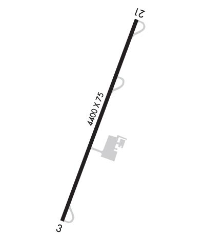
    Runway Identifications
    Runway Identification: 03/21
    Length: 4400 ft
    Width: 75 ft
    Surface: ASPHALT
    Edge lights: Medium Intensity

    Treatment: GROOVED

     Runway: 03   Runway: 21
    Mag heading: 29°Mag heading: 209°
    Rwy Slope: .14% UpRwy Slope: -.14% Down
    Approach: Approach:
    Pattern: Left TrafficPattern: Left Traffic
    Markings: NONPRECISION INSTRUMENTMarkings: NONPRECISION INSTRUMENT
    Marking Condition: GOODMarking Condition: GOOD
    Arresting Dev: Arresting Dev:
    Lat & Long: N3721.1  W07826.4Lat. & Long.: N3721.8  W07826.1
    Elev: 409.7 ft. MSLElev: 415.7 ft. MSL
    TCH: 44 ft. AGLTCH: 45 ft. AGL
    Visual Glide Path: 3.00 degreesVisual Glide Path: 3.00 degrees
    Displaced Threshold: NoDisplaced Threshold: No
    Touchdown Zone: YESTouchdown Zone: YES
    Touchdown Elev.: 409.9 feetTouchdown Elev.: 415.7 feet
    Visual Glide Slope: 2-Light PAPI on LEFT side of RunwayVisual Glide Slope: 2-Light PAPI on LEFT side of Runway
    RVR Equipment: RVR Equipment:
    RVV Equipment: NORVV Equipment: NO
    Approach Lights: Approach Lights:
    REIL: YESREIL: YES
    Centerline Lights: NOCenterline Lights: NO
    Touchdown lights: NOTouchdown lights: NO
    Runway Category: Runway with a Non-precision Approach having visibility minimums greater than 3/4 mileRunway Category: Runway with a Non-precision Approach having visibility minimums greater than 3/4 mile
    Declared Distances: Declared Distances:
    Obstructions: HILL; TERRAIN 333 FT FROM THR, 128 RIGHT OF CTLN AND 10 FT ABOVE RWY ELEVATION.Obstructions: TREE
    Marked: NOT Marked/LightedMarked: NOT Marked/Lighted
    Clearance slope: 13:1Clearance slope: 12:1
    Obstruction height: 10 feet AGLObstruction height: 35 feet AGL
    Dist. from runway: 333 feetDist. from runway: 652 feet
    Centerline offset: 128 left of centerlineCenterline offset: 291 feet right of centerline
    Comments: Comments:
    C:2/P: