| |||||||||||||||||||||||||||||||||||||||||||||||||||||||||||||||||||||
| |||||||||||||||||||||||||||||||||||||||||||||||||||||||||||||||||||||
| |||||||||||||||||||||||||||||||||||||||||||||||||||||||||||||||||||||
| |||||||||||||||||||||||||||||||||||||||||||||||||||||||||||||||||||||
| |||||||||||||||||||||||||||||||||||||||||||||||||||||||||||||||||||||
| |||||||||||||||||||||||||||||||||||||||||||||||||||||||||||||||||||||
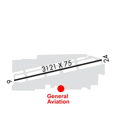
| Rwy | Rwy | |||||||
| 3121x75 | 2694' | 3121x75 | 2868' | 108.90 - 242° | ||||
| Runway ID | Single Wheel | Double Wheel | Double Tandem Wheel | Dual Double Wheel |
| 06/24 | 12,500 | N/A | N/A | N/A |
| H1 | N/A | N/A | N/A | N/A |
| These numbers are Advisory and are not limits. The Airport Manager should have more accurate Weight Limits | ||||
 Airport Diagram might not be current. | |
| Facility Name: | FULLERTON MUNI |
| City Name: | FULLERTON |
| County: | ORANGE |
| State abbrev: | CA |
| State Name: | CALIFORNIA |
| Ownership: | PUBLICLY OWNED |
| Use: | OPEN TO THE PUBLIC |
| Owner's Name: | CITY OF FULLERTON |
| Address: | 303 W. COMMONWEALTH AVE |
| FULLERTON, CA 92832 | |
| Owner's Phone: | 714-738-6310 |
| Manager's Name: | BRENDAN O'REILLY |
| Address: | 4011 W COMMONWEALTH AVE |
| FULLERTON, CA 92833-2537 | |
| Phone: | 714-738-6323 |
| FAA Region: | WESTERN-PACIFIC |
| FAA Field Office: | LAX |
| Date | Sunrise | Sunset |
|---|---|---|
| 04/19/24 Friday | 6:15 | 19:27 |
| 04/20/24 Saturday | 6:14 | 19:28 |
| 04/21/24 Sunday | 6:13 | 19:28 |
| 04/22/24 Monday | 6:12 | 19:29 |
| 04/23/24 Tuesday | 6:11 | 19:30 |
| 04/24/24 Wednesday | 6:10 | 19:31 |
| 04/25/24 Thursday | 6:08 | 19:32 |
| 04/26/24 Friday | 6:07 | 19:32 |
| 04/27/24 Saturday | 6:06 | 19:33 |
| 04/28/24 Sunday | 6:05 | 19:34 |
| 04/29/24 Monday | 6:04 | 19:35 |
| 04/30/24 Tuesday | 6:03 | 19:35 |
| 05/01/24 Wednesday | 6:02 | 19:36 |
| 05/02/24 Thursday | 6:01 | 19:37 |
| Airport Attendance Schedule | 7 Days A Week 0700-2100 |
| Airport Status | OPERATIONAL (This Status can change at any time - please check NOTAMS) |
| Airport Lighting Schedule | WHEN ATCT CLSD ACTVT RLLS RWY 24; REIL RWY 06 & 24; PVASI RWY 06; PAPI RWY 24; MIRL RWY 06/24; TWY LGTS - CTAF. |
| Airport Storage Available | Tie Downs |
| Extra Services Available | Air Ambulance, Charter, Flight Instruction, Aircraft Rental, Aircraft Sales |
| Wind Indicator | YES - (lighted) |
| Control Tower | YES |
| CTAF Frequency | 119.100 |
| Unicom Frequency | 122.950 |
| Rotating Beacon Color | WG |
| Segmented Circle | YES |
| Landing Fee | NO |
| Airport Inspected | STATE - performed by STATE AERONAUTICAL PERSONNEL |
| Inspection Date | 07/19/2022 |
| Type of Fuel Available | Grade 100LL, JET A (freeze point -40C) |
| Airframe Repair Service | MAJOR |
| Power Plant Repair Service | MAJOR |
| Latitude | N3352.3 |
| Longitude | W11758.8 (ESTIMATED) |
| Arpt Elevation | 96ft (SURVEYED) |
| Magnetic Variation | 14E |
| 3 miles W | of FULLERTON |
| Traffic Pattern Altitude | 1004 |
| Sectional Chart | LOS ANGELES |
| Operations (Reported) | Yearly | Avg. Daily |
|---|---|---|
| General Aviation Transient | 46249 | 127 |
| General Aviation Local | 31306 | 86 |
| Air Taxi | 160 | 0 |
| Commerical | 4 | 0 |
| Commuter | 0 | 0 |
| Military | 143 | 0 |
| Aircraft based on Field | |
|---|---|
| General Aviation Singles | 283 |
| General Aviation Multi | 10 |
| Jet Aircraft | 0 |
| General Aviation Helicopters | 14 |
| Military Aircraft | 0 |
| Gliders | 2 |
| Ultralights | 3 |
| FSS on field | NO |
| FSS tie-in | RIVERSIDE |
| FSS Phone | 1-800-WX-BRIEF |
| Who issues Notams | FUL |
| Notam D service at airport | YES |
| ARTCC Name | LOS ANGELES |
| Airport Certification | |
| Aircraft Rescue & Firefighting Index | None |
| Airport of Entry | No |
| Custom Landing Rights | No |
| Joint Civil/Military | No |
| Military Landing rights | YES |
| NATIONAL PLAN OF INTEGRATED AIRPORT SYSTEMS (NPIAS) |
| GRANT AGREEMENTS UNDER FAAP/ADAP/AIP |
| ASSURANCES PURSUANT TO TITLE VI, CIVIL RIGHTS ACT OF 1964 |
| THIS AIRPORT HAS BEEN SURVEYED BY THE NATIONAL GEODETIC SURVEY. |
| ARPT HAS NOISE ABATEMENT PROCEDURES CTC AMGR (714) 738-6323. |
| PORTIONS OF TWY A ADJACENT TO THE APCH END OF RWY 24 NOT VSBL FM ATCT. |
| RY 06 CALM WIND RY. |
| PORTIONS OF TWY A BTN INTERSECTION F & WEST END NOT VSBL FM ATCT. |
| FOR NOISE ABATEMENT RY 06 PREFERRED FOR TKOF; FOLLOW RR TRACKS TO EAST WITH NO TURNS BLO 1000 FT AGL. RY 24 DEP CLIMB TO 700 FT AGL PRIOR TO TURNS. |
| (84) SEGMENTED CIRCLE LGTD. |
| LGTD 750 FT TOWER 1.75 MILES WEST OF ARPT ON HEADING OF 285 DEG FROM ARPT. |
| FOR CD WHEN ATCT CLSD CTC SOCAL APCH AT 800-448-3724. |
Airport Communications & Frequencies:
| |||||||||||||||||||||||
| Runway: 06 | Runway: 24 | ||
| Mag heading: | 63° | Mag heading: | 243° |
| Rwy Slope: | .34% Up | Rwy Slope: | -.34% Down |
| Approach: | Approach: | LOC/DME | |
| Pattern: | Left Traffic | Pattern: | Right Traffic |
| Markings: | BASIC | Markings: | NONPRECISION INSTRUMENT |
| Marking Condition: | GOOD | Marking Condition: | GOOD |
| Arresting Dev: | Arresting Dev: | ||
| Lat & Long: | N3352.3 W11759.1 | Lat. & Long.: | N3352.4 W11758.5 |
| Elev: | 84.9 ft. MSL | Elev: | 95.5 ft. MSL |
| TCH: | 32 ft. AGL | TCH: | 33 ft. AGL |
| Visual Glide Path: | 4.00 degrees | Visual Glide Path: | 4.00 degrees |
| Displaced Threshold: | 427 feet | Displaced Threshold: | 253 feet |
| Touchdown Zone: | YES | Touchdown Zone: | YES |
| Touchdown Elev.: | 96.0 feet | Touchdown Elev.: | 95.0 feet |
| Visual Glide Slope: | PULSATING/STEADY BURNING VASI ON LEFT SIDE OF RUNWAY | Visual Glide Slope: | 4-Light PAPI on LEFT side of Runway |
| RVR Equipment: | RVR Equipment: | ||
| RVV Equipment: | NO | RVV Equipment: | NO |
| Approach Lights: | Approach Lights: | RLLS | |
| REIL: | YES | REIL: | YES |
| Centerline Lights: | NO | Centerline Lights: | NO |
| Touchdown lights: | NO | Touchdown lights: | NO |
| Runway Category: | Runway with a Visual Approach | Runway Category: | Runway with a Non-precision Approach |
| Declared Distances: | Declared Distances: | ||
| Obstructions: | Obstructions: | RR | |
| Marked: | Marked: | NOT Marked/Lighted | |
| Clearance slope: | 20:1; APCH RATIO 14:1 TO DSPLCD THR. | Clearance slope: | 1:1; APCH RATIO 15:1 TO DSPLCD THR. |
| Obstruction height: | Obstruction height: | 23 feet AGL | |
| Dist. from runway: | Dist. from runway: | 225 feet | |
| Centerline offset: | Centerline offset: | 80 feet right of centerline | |
| Comments: | +8 FT FENCE AT 55 FT & +15 FT STREET AT 65 FT FM APCH END RY 06. | Comments: | +8 FT FENCE AT 15 FT & +15 FT STREET AT 17 FT; POLE & RR AT 100 FT FM APCH END RY 24. |