Professionalism, flexibility and a commitment to customer service

KFTY

Whisper PlateWhisper Track
FULTON COUNTY AIRPORT-BROWN
ATLANTA
GA
Time Zone: Eastern
Lat: N 3346.7
Long: W 08431.3
Elev: 841
Var: +05
Longest Runway: 5797
Dept. ATIS: 120.17
Arr. ATIS: 120.17
Ground: 121.7
Tower: 118.45

FBO & Flight Services info for KFTY

FBOs: Update your Fuel Prices

  click here  
ATLANTA'S ONLY INDEPENDENT, FAMILY OWNED FBO OPERATION SINCE 1955.

AIN top rated FBO in Atlanta and #1 at KFTY. Uncompromising safety, a passion for customer service, and an experienced dedication to aviation at every level - that's the Hill way! We are your aviation solutions company most conveniently located to Atlanta's major events and metro areas. See more about what we have to offer.
Ph: 800-827-8305 Fax: 404-691-1446 Freq: 129.57WebsiteE-Mail
                     
Service
Jet
100LL
SAF
MoGas
Fuel Avail: 24 Hours
Full7.878.13    Last Update: 04/16/2024 10:02
PRICES GUARANTEED by FBO. *
*CAA, Colt, UV Air Discounts
Self        
Misc. Info: Open 6 AM. Close 11 PM. Fee for after hours fuelAddress: 3948 AVIATION CIRCLE,   ATLANTA, GA 30336

  click here  
Located west of Atlanta, Fulton County Airport at Charlie Brown Field is nearest airport to Hartsfield-Jackson Atlanta International Airport. Whatever your ultimate destination, Signature - Fulton County offers the best of the business and leisure worlds.
Ph: 404-443-0231 Fax: 404-443-0270 Freq: 130.57WebsiteE-Mail
                             
Service
Jet
100LL
SAF
MoGas
Fuel Avail: Jet A w/Prist, add $0.06 per gallon. 06:00 - 22:00 /7 days a week - Surcharge after hours
Full7.898.77    Last Update: 04/18/2024 12:04
PRICES GUARANTEED by FBO.
Self        
Misc. Info: $0.50 weekend discount on avgasAddress: 3956 AVIATION CIR NW, PO BOX 43147,   ATLANTA, GA 30336-1500

ASOSPh: 404-696-5660
-
-
 
If you are an FBO, call 1-203-262-1700 to update your info or email: FltPlan.Advertising@garmin.com
Advertise your FBO on FltPlan.com

Runway & Approach Info for KFTY
Rwy
Length
Land Dist**
Approach*
  Rwy
Length
Land Dist**
Approach*
08
5797x100  5797'          
ILS
 109.10 - 084°  
  
26
  5797x100  5797'          
 
14
4158x100  4158'          
 
  
32
  4158x100  3958'          
 
 * only ILS, LOC, LDA, and SDF approaches to a specific runway are shown
** For any Declared Landing Distance Available, please see A/FD or Approach plates
Runway Weight Capability (lbs.) Help
Runway IDSingle WheelDouble WheelDouble Tandem WheelDual Double Wheel
08/26105,000121,000198,000N/A
14/3230,000N/AN/AN/A
These numbers are Advisory and are not limits.   The Airport Manager should have more accurate Weight Limits
Approach Charts
Approaches    
Current Weather/Notams
Customs Information Send updates to Support@FltPlan.com
Phone 404-765-2300
Fax 404-765-1237

Comments On call basis *Maximum passengers per flight: 30. Email ATLentrance@cbp.dhs.gov to request landing rights.
Database effective 04/18/2024
Airport Diagram of KFTY
Airport Diagram might not be current.

Facility Name: FULTON COUNTY EXEC/CHARLIE BROWN FLD
City Name: ATLANTA
County: FULTON
State abbrev: GA
State Name: GEORGIA
   
Ownership: PUBLICLY OWNED
Use: OPEN TO THE PUBLIC
Owner's Name: FULTON COUNTY
Address: COUNTY COURTHOUSE, 141 PRYOR ST.
 ATLANTA, GA 30303
Owner's Phone: 404-699-4200
  
Manager's Name: JONATHAN GAUTHIER
Address: 3952 AVIATION CIRCLE NW
 ATLANTA, GA 30336
Phone: 404-613-4205
   
FAA Region: SOUTHERN
FAA Field Office: ATL
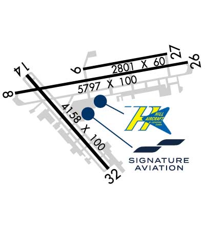
Joseph Pelton - www.aviationonlinetraining.net


Click here for full scale & interactive Sectional view of KFTY


Sunrise / Sunset times for FULTON COUNTY EXEC/CHARLIE BROWN FLD

DateSunriseSunset
04/17/24 Wednesday7:0420:11
04/18/24 Thursday7:0320:12
04/19/24 Friday7:0220:13
04/20/24 Saturday7:0120:14
04/21/24 Sunday6:5920:14
04/22/24 Monday6:5820:15
04/23/24 Tuesday6:5720:16
04/24/24 Wednesday6:5620:17
04/25/24 Thursday6:5520:17
04/26/24 Friday6:5420:18
04/27/24 Saturday6:5320:19
04/28/24 Sunday6:5220:20
04/29/24 Monday6:5120:21
04/30/24 Tuesday6:5020:21

Airport Facilities

Airport Attendance ScheduleCONTINUOUS
Airport Status OPERATIONAL (This Status can change at any time - please check NOTAMS)
Airport Lighting ScheduleSS-SR
Airport Storage AvailableTie Downs, Hanger
Extra Services AvailableAir Freight, Air Ambulance, Avionics, Cargo Handling, Charter, Flight Instruction, Aircraft Rental
Wind IndicatorYES - (unlit)
Control TowerYES
CTAF Frequency
Unicom Frequency122.950
Rotating Beacon ColorWG
Segmented CircleYES
Landing FeeNO

Airport Inspection Data

Airport InspectedSTATE - performed by STATE AERONAUTICAL PERSONNEL
Inspection Date03/30/2022

Airport Services

Type of Fuel AvailableGrade 100LL, JET A; -10FUEL SVC HILL AVN, C404-691-3330.
Airframe Repair ServiceMAJOR
Power Plant Repair ServiceMAJOR

Geographic Data

LatitudeN3346.7
LongitudeW08431.3 (ESTIMATED)
Arpt Elevation841ft (SURVEYED)
Magnetic Variation05W
6 miles Wof ATLANTA
Traffic Pattern Altitude
Sectional ChartATLANTA

Aircraft Data

Operations (Reported)YearlyAvg. Daily
General Aviation Transient 45240124
General Aviation Local 3420994
Air Taxi 00
Commerical 00
Commuter 00
Military 00
Aircraft based on Field
General Aviation Singles 30
General Aviation Multi 5
Jet Aircraft 41
General Aviation Helicopters 3
Military Aircraft 0
Gliders 0
Ultralights 0

FAA Services

FSS on field NO
FSS tie-in MACON
FSS Phone 1-800-WX-BRIEF
Who issues Notams FTY
Notam D service at airport YES
ARTCC Name ATLANTA

Federal Status

Airport Certification
Aircraft Rescue & Firefighting IndexNone
Airport of EntryNo
Custom Landing RightsYES
Joint Civil/MilitaryNo
Military Landing rightsYES

Federal Agreements

NATIONAL PLAN OF INTEGRATED AIRPORT SYSTEMS (NPIAS)
GRANT AGREEMENTS UNDER FAAP/ADAP/AIP
ASSURANCES PURSUANT TO TITLE VI, CIVIL RIGHTS ACT OF 1964

Remarks

FLOCKS OF BIRDS ON AND INVOF ARPT DURING DALGT HRS.
NOISE SENSITIVE AREA ALL QUADRANTS; NO RUN UPS AUTHORIZED ON ANY RAMPS.
DEER AND OTHER WILDLIFE ON & INVOF ARPT.
Airport Communications & Frequencies:
ATIS Frequencies:   Hours(local) of Operation: CONTINUOUS
120.175
FULTON COUNTY Tower Frequencies:   Hours(local) of operation: CONTINUOUS   
118.45
257.8
FULTON COUNTY Ground Frequencies:
121.7
348.6
Unicom Frequency:
122.950
Remarks
  • EMERG FREQ 121.5 NOT AVBL.
  • ATLANTA Primary Approach Frequencies:  
    121.0
    268.7
    ATLANTA Primary Departure Frequencies:  
    121.0
    268.7
    Runway Identifications
    Runway Identification: 08/26
    Length: 5797 ft
    Width: 100 ft
    Surface: ASPHALT-GOOD CONDITION
    Edge lights: High Intensity

    Treatment: GROOVED

     Runway: 08   Runway: 26
    Mag heading: 85°Mag heading: 265°
    Rwy Slope: .24% UpRwy Slope: -.24% Down
    Approach: ILSApproach:
    Pattern: Left TrafficPattern: Right Traffic
    Markings: PRECISION INSTRUMENTMarkings: PRECISION INSTRUMENT
    Marking Condition: GOODMarking Condition: GOOD
    Arresting Dev: Arresting Dev:
    Lat & Long: N3346.7  W08431.8Lat. & Long.: N3346.9  W08430.7
    Elev: 799.9 ft. MSLElev: 814.1 ft. MSL
    TCH: TCH: 50 ft. AGL
    Visual Glide Path: Visual Glide Path: 3.00 degrees
    Displaced Threshold: NoDisplaced Threshold: No
    Touchdown Zone: YESTouchdown Zone: YES
    Touchdown Elev.: 807.5 feetTouchdown Elev.: 814.3 feet
    Visual Glide Slope: Visual Glide Slope: 4-BOX VASI ON LEFT SIDE OF RUNWAY
    RVR Equipment: RVR Equipment:
    RVV Equipment: NORVV Equipment: NO
    Approach Lights: MALSR - 1,400 foot medium intensity approach lighting system with runway alignment indicator lightsApproach Lights:
    REIL: NOREIL: YES
    Centerline Lights: NOCenterline Lights: NO
    Touchdown lights: NOTouchdown lights: NO
    Runway Category: Precision Instrument RunwayRunway Category: Runway with a Non-precision Approach having visibility minimums greater than 3/4 mile
    Declared Distances: Declared Distances:
    Obstructions: Obstructions: TREES
    Marked: Marked: NOT Marked/Lighted
    Clearance slope: 50:1Clearance slope:
    Obstruction height: Obstruction height: 30 feet AGL
    Dist. from runway: Dist. from runway: 201 feet
    Centerline offset: Centerline offset: 300 feet right of centerline
    Comments: Comments: 20+ FT TREES AT THLD 300-500 FT R OUT TO 200 FT.
    Runway Identification: 14/32
    Length: 4158 ft
    Width: 100 ft
    Surface: ASPHALT-FAIR CONDITION
    Edge lights: Medium Intensity

    Treatment: NONE

     Runway: 14   Runway: 32
    Mag heading: 144°Mag heading: 324°
    Rwy Slope: 1.02% UpRwy Slope: -1.02% Down
    Approach: Approach:
    Pattern: Left TrafficPattern: Left Traffic
    Markings: BASICMarkings: BASIC
    Marking Condition: FAIRMarking Condition: FAIR
    Arresting Dev: Arresting Dev:
    Lat & Long: N3346.8  W08431.7Lat. & Long.: N3346.3  W08431.2
    Elev: 798.7 ft. MSLElev: 841.1 ft. MSL
    TCH: 48 ft. AGLTCH:
    Visual Glide Path: 4.00 degreesVisual Glide Path:
    Displaced Threshold: NoDisplaced Threshold: 200 feet
    Touchdown Zone: YESTouchdown Zone: YES
    Touchdown Elev.: 823.7 feetTouchdown Elev.: 839.1 feet
    Visual Glide Slope: 2-Light PAPI on LEFT side of RunwayVisual Glide Slope:
    RVR Equipment: RVR Equipment:
    RVV Equipment: NORVV Equipment: NO
    Approach Lights: Approach Lights:
    REIL: YESREIL: YES
    Centerline Lights: NOCenterline Lights: NO
    Touchdown lights: NOTouchdown lights: NO
    Runway Category: Runway with a Visual ApproachRunway Category: Runway with a Visual Approach
    Declared Distances: TORA:4158' TODA:4158' ASDA:4158' LDA:4158'Declared Distances: TORA:4158' TODA:4158'
    Obstructions: TREESObstructions: TREES; THREE LGTD TOWERS ON CNTRLN 32 FT & 650 FT FROM THLD.
    Marked: NOT Marked/LightedMarked: NOT Marked/Lighted
    Clearance slope: 13:1Clearance slope: 15:1; RY 32 APCH RATIO 20:1 TO DSPLCD THLD. 87FT TREES 1740FT FROM DSPLCD THLD.
    Obstruction height: 27 feet AGLObstruction height: 90 feet AGL
    Dist. from runway: 551 feetDist. from runway: 1550 feet
    Centerline offset: 84 right of centerlineCenterline offset: 164 feet right of centerline
    Comments: Comments:
    C:172/P: