Click here for more info on on SMS!

KCFO

COLORADO AIR AND SPACE PORT
DENVER
CO
Time Zone: Mountain
Lat: N 3947.1
Long: W 10432.3
Elev: 5515
Var: -08
Longest Runway: 8002
Clr Del: 124.7/121.75
Dept. ATIS: 119.02
Arr. ATIS: 119.02
AWOS: 119.02
Ground: 124.7
Tower: 120.2

FBO & Flight Services info for KCFO

FBOs: Update your Fuel Prices

  click here  
Located Just 6 Miles Southeast of the Denver International Airport. Providing our Customers with Shuttle Service to KDEN in just 18 Minutes! Quality Fueling, Catering, On Site Rental Cars, Courtesy Cars, Professional and Friendly FBO Personnel on Duty from 7am-9pm. Heated Hangars to Accommodate up to a Gulfstream 550.
Ph: 303-261-9100 Fax: 303-261-9195 Freq: 122.95WebsiteE-Mail
                   
Service
Jet
100LL
SAF
MoGas
Fuel Avail: JETA INCLUDES PRIST, 7A-5P, 100LL (SS) Available 24/7
Full6.256.74    Last Update: 04/12/2024 15:24

Self  6.24    
Misc. Info: 100LL Self-Serve Pump available 24/7Address: 5200 FRONT RANGE PARKWAY   WATKINS, COLORADO 80137

AWOSPh: 303-261-9104
-
Freq: 119.02  
If you are an FBO, call 1-203-262-1700 to update your info or email: FltPlan.Advertising@garmin.com
Advertise your FBO on FltPlan.com

Runway & Approach Info for KCFO
Rwy
Length
Land Dist**
Approach*
  Rwy
Length
Land Dist**
Approach*
08
8002x100  8002'          
 
  
26
  8002x100  8002'          
ILS/DME
 109.30 - 263°  
17
8000x100  8000'          
ILS/DME
 110.90 - 171°  
  
35
  8000x100  8000'          
ILS/DME
 110.90 - 351°  
 * only ILS, LOC, LDA, and SDF approaches to a specific runway are shown
** For any Declared Landing Distance Available, please see A/FD or Approach plates
Runway Weight Capability (lbs.) Help
Runway IDSingle WheelDouble WheelDouble Tandem WheelDual Double Wheel
08/2628,00040,000N/AN/A
17/3534,00075,000N/AN/A
These numbers are Advisory and are not limits.   The Airport Manager should have more accurate Weight Limits
Approach Charts
Approaches    
Current Weather/Notams
Customs Information Send updates to Support@FltPlan.com
Customs Not Available
Database effective 04/18/2024
Airport Diagram of KCFO
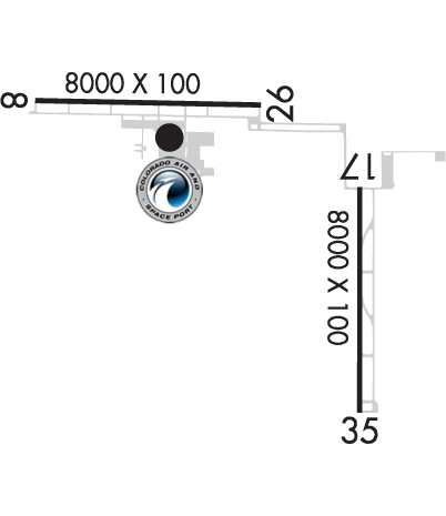
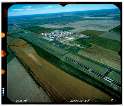
Airport Diagram might not be current.

Facility Name: COLORADO AIR AND SPACE PORT
City Name: DENVER
County: ADAMS
State abbrev: CO
State Name: COLORADO
   
Ownership: PUBLICLY OWNED
Use: OPEN TO THE PUBLIC
Owner's Name: ADAMS COUNTY
Address: 4430 SOUTH ADAMS COUNTY PKWY
 BRIGHTON, CO 80601
Owner's Phone: (303) 659-2120
  
Manager's Name: JEFF KLOSKA
Address: 5200 FRONT RANGE PKWY
 WATKINS, CO 80137
Phone: 303-261-9100
   
FAA Region: NORTHWEST MOUNTAIN
FAA Field Office: DEN
Courtesy of Aerial Surveys International, LLC


Click here for full scale & interactive Sectional view of KCFO


Sunrise / Sunset times for COLORADO AIR AND SPACE PORT

DateSunriseSunset
04/15/24 Monday6:1919:37
04/16/24 Tuesday6:1819:38
04/17/24 Wednesday6:1619:39
04/18/24 Thursday6:1519:40
04/19/24 Friday6:1419:41
04/20/24 Saturday6:1219:42
04/21/24 Sunday6:1119:43
04/22/24 Monday6:0919:44
04/23/24 Tuesday6:0819:45
04/24/24 Wednesday6:0719:46
04/25/24 Thursday6:0519:47
04/26/24 Friday6:0419:48
04/27/24 Saturday6:0319:49
04/28/24 Sunday6:0119:50

Airport Facilities

Airport Attendance Schedule7 Days A Week 0700-2100; AFT HR SVC - AMGR.
Airport Status OPERATIONAL (This Status can change at any time - please check NOTAMS)
Airport Lighting ScheduleACTVT MALSR RWY 26 & 35; REIL RWY 08 & 17; PAPI RWY 08 & 26, 17 & 35; HIRL RWY 08/26; MIRL RWY 17/35 - CTAF.
Airport Storage AvailableTie Downs, Hanger
Extra Services AvailableCrop Dusting, Avionics, Charter, Flight Instruction, Aircraft Rental, Aircraft Sales
Wind IndicatorYES - (lighted)
Control TowerYES
CTAF Frequency120.200
Unicom Frequency122.950
Rotating Beacon ColorWG
Segmented CircleYES
Landing FeeNO

Airport Inspection Data

Airport InspectedSTATE - performed by STATE AERONAUTICAL PERSONNEL
Inspection Date07/09/2020

Airport Services

Type of Fuel AvailableGrade 100LL, JET A (freeze point -40C); -10100LL SELF SVC AVBL H24 WITH CREDIT CARD.
Airframe Repair ServiceMAJOR
Power Plant Repair ServiceMAJOR

Geographic Data

LatitudeN3947.1
LongitudeW10432.3 (ESTIMATED)
Arpt Elevation5515ft (SURVEYED)
Magnetic Variation08E
19 miles Eof DENVER
Traffic Pattern Altitude988
Sectional ChartDENVER

Aircraft Data

Operations (Reported)YearlyAvg. Daily
General Aviation Transient 3287590
General Aviation Local 41624114
Air Taxi 560
Commerical 00
Commuter 00
Military 10923
Aircraft based on Field
General Aviation Singles 247
General Aviation Multi 38
Jet Aircraft 2
General Aviation Helicopters 4
Military Aircraft 0
Gliders 0
Ultralights 1

FAA Services

FSS on field NO
FSS tie-in DENVER
FSS Phone 1-800-WX-BRIEF
Who issues Notams CFO
Notam D service at airport YES
ARTCC Name DENVER

Federal Status

Airport Certification
Aircraft Rescue & Firefighting IndexNone
Airport of EntryNo
Custom Landing RightsNo
Joint Civil/MilitaryNo
Military Landing rightsYES

Federal Agreements

NATIONAL PLAN OF INTEGRATED AIRPORT SYSTEMS (NPIAS)
GRANT AGREEMENTS UNDER FAAP/ADAP/AIP
ASSURANCES PURSUANT TO TITLE VI, CIVIL RIGHTS ACT OF 1964

Remarks

TWY EDGE LIGHTS ALONG A, B, C, D, & E.
NOISE SENSITIVE AREAS SE, S & SW OF ARPT. AVOID FLT BLW 1000 FT OVR POPULATED AREAS.
CTN: USAF TRNG ACT INVOF COLORADO SPRINGS & PUEBLO ARPT.
Airport Communications & Frequencies:
ATIS Frequencies:   Hours(local) of Operation: CONTINUOUS
119.025
SPACE PORT Tower Frequencies:   Hours(local) of operation: 0700-2100   
120.2
SPACE PORT Ground Frequencies:
124.7
Clearance Delivery Frequencies:
124.7
121.75
CTAF Frequency:
120.200
Unicom Frequency:
122.950
DENVER Primary Approach Frequencies:  
128.25
371.95
DENVER Primary Departure Frequencies:  
128.25
371.95
Runway Identifications
Runway Identification: 08/26
Length: 8002 ft
Width: 100 ft
Surface: ASPHALT-GOOD CONDITION
Edge lights: High Intensity

Treatment: NONE

 Runway: 08   Runway: 26
Mag heading: 83°Mag heading: 263°
Rwy Slope: .45% UpRwy Slope: -.45% Down
Approach: Approach: ILS/DME
Pattern: Right TrafficPattern: Left Traffic
Markings: PRECISION INSTRUMENTMarkings: PRECISION INSTRUMENT
Marking Condition: FAIRMarking Condition: FAIR
Arresting Dev: Arresting Dev:
Lat & Long: N3947.6  W10433.9Lat. & Long.: N3947.6  W10432.2
Elev: 5453.4 ft. MSLElev: 5489.1 ft. MSL
TCH: 50 ft. AGLTCH: 50 ft. AGL
Visual Glide Path: 3.00 degreesVisual Glide Path: 3.00 degrees
Displaced Threshold: NoDisplaced Threshold: No
Touchdown Zone: YESTouchdown Zone: YES
Touchdown Elev.: 5470.0 feetTouchdown Elev.: 5489.1 feet
Visual Glide Slope: 2-Light PAPI on LEFT side of RunwayVisual Glide Slope: 2-Light PAPI on LEFT side of Runway
RVR Equipment: RVR Equipment:
RVV Equipment: NORVV Equipment: NO
Approach Lights: Approach Lights: MALSR - 1,400 foot medium intensity approach lighting system with runway alignment indicator lights
REIL: YESREIL: NO
Centerline Lights: NOCenterline Lights: NO
Touchdown lights: NOTouchdown lights: NO
Runway Category: Runway with a Visual ApproachRunway Category: Precision Instrument Runway
Declared Distances: Declared Distances:
Runway Identification: 17/35
Length: 8000 ft
Width: 100 ft
Surface: ASPHALT-GOOD CONDITION
Edge lights: Medium Intensity

Treatment: NONE

 Runway: 17   Runway: 35
Mag heading: 172°Mag heading: 352°
Rwy Slope: .48% UpRwy Slope: -.48% Down
Approach: ILS/DMEApproach: ILS/DME
Pattern: Left TrafficPattern: Right Traffic
Markings: PRECISION INSTRUMENTMarkings: PRECISION INSTRUMENT
Marking Condition: FAIRMarking Condition: FAIR
Arresting Dev: Arresting Dev:
Lat & Long: N3947.1  W10431.5Lat. & Long.: N3945.8  W10431.5
Elev: 5476.5 ft. MSLElev: 5515.2 ft. MSL
TCH: 55 ft. AGLTCH: 56 ft. AGL
Visual Glide Path: 3.00 degreesVisual Glide Path: 3.00 degrees
Displaced Threshold: NoDisplaced Threshold: No
Touchdown Zone: YESTouchdown Zone: YES
Touchdown Elev.: 5491.2 feetTouchdown Elev.: 5515.2 feet
Visual Glide Slope: 4-Light PAPI on LEFT side of RunwayVisual Glide Slope: 4-Light PAPI on LEFT side of Runway
RVR Equipment: RVR Equipment:
RVV Equipment: NORVV Equipment: NO
Approach Lights: Approach Lights: MALSR - 1,400 foot medium intensity approach lighting system with runway alignment indicator lights
REIL: YESREIL: NO
Centerline Lights: NOCenterline Lights: NO
Touchdown lights: NOTouchdown lights: NO
Runway Category: Precision Instrument RunwayRunway Category: Precision Instrument Runway
Declared Distances: Declared Distances:
Obstructions: Obstructions: PLINE
Marked: Marked: NOT Marked/Lighted
Clearance slope: 50:1Clearance slope: 49:1
Obstruction height: Obstruction height: 74 feet AGL
Dist. from runway: Dist. from runway: 3870 feet
Centerline offset: Centerline offset:
Comments: Comments:
C:17/P: